Morris County Rolled Sketch 2A
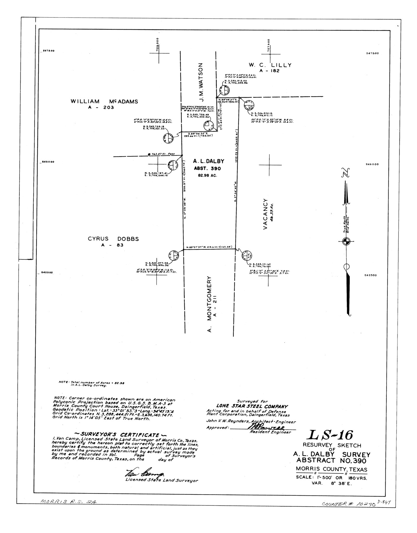
LS-16 - Resurvey sketch of A.L. Dalby survey, abstract no. 390, Morris County, Texas
-
Map/Doc
10240
-
Collection
General Map Collection
-
People and Organizations
Van Camp (Surveyor/Engineer)
-
Counties
Morris
-
Subjects
Surveying Rolled Sketch
-
Height x Width
24.0 x 18.8 inches
61.0 x 47.8 cm
-
Medium
linen, manuscript
-
Scale
1" = 180 varas
-
Comments
See Morris County Rolled Sketch 2 (9550) for map of all retracement surveys made for Lone Star Steel Company.
Related maps
Morris County Rolled Sketch 2

Print $40.00
- Digital $50.00
Morris County Rolled Sketch 2
1944
Size 59.4 x 43.5 inches
Map/Doc 9550
Part of: General Map Collection
Flight Mission No. BRA-9M, Frame 62, Jefferson County

Print $20.00
- Digital $50.00
Flight Mission No. BRA-9M, Frame 62, Jefferson County
1953
Size 18.7 x 22.3 inches
Map/Doc 85645
Val Verde County Rolled Sketch 59

Print $20.00
- Digital $50.00
Val Verde County Rolled Sketch 59
1947
Size 45.2 x 23.6 inches
Map/Doc 10078
Map of the East Part of Tom Green County

Print $40.00
- Digital $50.00
Map of the East Part of Tom Green County
1894
Size 45.9 x 49.4 inches
Map/Doc 63071
Kinney County Working Sketch 13

Print $20.00
- Digital $50.00
Kinney County Working Sketch 13
1941
Size 20.3 x 23.9 inches
Map/Doc 70195
Hudspeth County Working Sketch 33

Print $20.00
- Digital $50.00
Hudspeth County Working Sketch 33
1977
Size 26.8 x 21.4 inches
Map/Doc 66318
Nolan County Working Sketch Graphic Index

Print $20.00
- Digital $50.00
Nolan County Working Sketch Graphic Index
1935
Size 41.6 x 36.9 inches
Map/Doc 76654
Maps of Gulf Intracoastal Waterway, Texas - Sabine River to the Rio Grande and connecting waterways including ship channels

Print $20.00
- Digital $50.00
Maps of Gulf Intracoastal Waterway, Texas - Sabine River to the Rio Grande and connecting waterways including ship channels
1966
Size 14.6 x 20.5 inches
Map/Doc 61991
Brewster County Rolled Sketch 99

Print $20.00
- Digital $50.00
Brewster County Rolled Sketch 99
1953
Size 26.6 x 22.4 inches
Map/Doc 5255
Map of Cherokee County

Print $20.00
- Digital $50.00
Map of Cherokee County
1877
Size 29.0 x 21.2 inches
Map/Doc 3389
Van Zandt County Rolled Sketch 4

Print $20.00
- Digital $50.00
Van Zandt County Rolled Sketch 4
1946
Size 34.7 x 35.5 inches
Map/Doc 10645
Trinity County Rolled Sketch 2

Print $20.00
- Digital $50.00
Trinity County Rolled Sketch 2
1948
Size 34.5 x 34.9 inches
Map/Doc 10024
Flight Mission No. CRC-3R, Frame 20, Chambers County

Print $20.00
- Digital $50.00
Flight Mission No. CRC-3R, Frame 20, Chambers County
1956
Size 18.6 x 22.2 inches
Map/Doc 84794
You may also like
[Surveys between Big Keechi Creek and the Trinity River]
![69753, [Surveys between Big Keechi Creek and the Trinity River], General Map Collection](https://historictexasmaps.com/wmedia_w700/maps/69753.tif.jpg)
Print $2.00
- Digital $50.00
[Surveys between Big Keechi Creek and the Trinity River]
Size 10.1 x 7.3 inches
Map/Doc 69753
Brazoria County Rolled Sketch 22

Print $20.00
- Digital $50.00
Brazoria County Rolled Sketch 22
1929
Size 28.1 x 40.8 inches
Map/Doc 10715
Flight Mission No. DQN-1K, Frame 109, Calhoun County

Print $20.00
- Digital $50.00
Flight Mission No. DQN-1K, Frame 109, Calhoun County
1953
Size 18.4 x 22.1 inches
Map/Doc 84176
[Leagues 67, 69, 70, 71, 72, 73, 75, 76, 719, 732, 733, 734, 735, 27, 28]
![90458, [Leagues 67, 69, 70, 71, 72, 73, 75, 76, 719, 732, 733, 734, 735, 27, 28], Twichell Survey Records](https://historictexasmaps.com/wmedia_w700/maps/90458-1.tif.jpg)
Print $20.00
- Digital $50.00
[Leagues 67, 69, 70, 71, 72, 73, 75, 76, 719, 732, 733, 734, 735, 27, 28]
Size 20.5 x 15.3 inches
Map/Doc 90458
Navarro County Sketch File 5

Print $6.00
- Digital $50.00
Navarro County Sketch File 5
1852
Size 5.5 x 8.1 inches
Map/Doc 32307
Flight Mission No. DAG-21K, Frame 127, Matagorda County

Print $20.00
- Digital $50.00
Flight Mission No. DAG-21K, Frame 127, Matagorda County
1952
Size 18.5 x 22.4 inches
Map/Doc 86453
Milam [District]
![1948, Milam [District], General Map Collection](https://historictexasmaps.com/wmedia_w700/maps/1948.tif.jpg)
Print $40.00
- Digital $50.00
Milam [District]
1850
Size 60.8 x 46.4 inches
Map/Doc 1948
Briscoe County Sketch File O-1

Print $2.00
- Digital $50.00
Briscoe County Sketch File O-1
1935
Size 11.3 x 7.2 inches
Map/Doc 16425
San Patricio County Rolled Sketch 27A

Print $40.00
- Digital $50.00
San Patricio County Rolled Sketch 27A
Size 50.4 x 38.5 inches
Map/Doc 9891
Presidio County Rolled Sketch 48

Print $20.00
- Digital $50.00
Presidio County Rolled Sketch 48
1908
Size 29.9 x 35.1 inches
Map/Doc 9775
Galveston County NRC Article 33.136 Sketch 35

Print $42.00
- Digital $50.00
Galveston County NRC Article 33.136 Sketch 35
2005
Size 24.3 x 36.6 inches
Map/Doc 83406
[Sketch with field note calls of the boundaries of Webb, Duval, Jim Wells,Nueces, Kleberg, Zapata, Jim Hogg, Brooks, Willacy, Starr, Hidalgo and Cameron Counties]
![1689, [Sketch with field note calls of the boundaries of Webb, Duval, Jim Wells,Nueces, Kleberg, Zapata, Jim Hogg, Brooks, Willacy, Starr, Hidalgo and Cameron Counties], General Map Collection](https://historictexasmaps.com/wmedia_w700/pdf_converted_jpg/qi_pdf_thumbnail_720.jpg)
Print $20.00
- Digital $50.00
[Sketch with field note calls of the boundaries of Webb, Duval, Jim Wells,Nueces, Kleberg, Zapata, Jim Hogg, Brooks, Willacy, Starr, Hidalgo and Cameron Counties]
1915
Size 21.9 x 26.2 inches
Map/Doc 1689