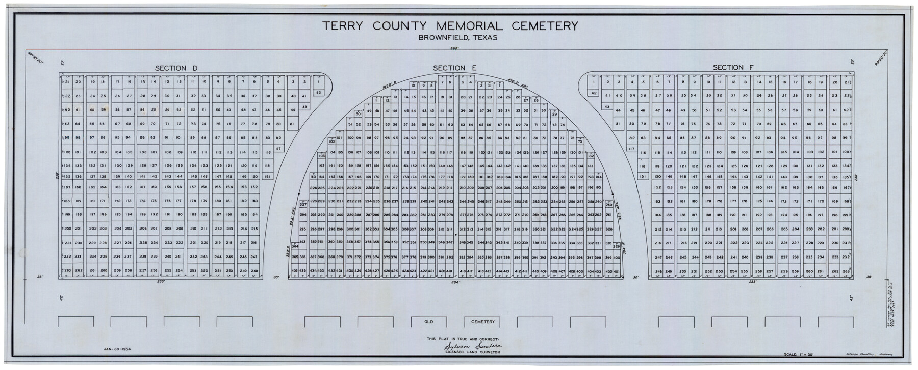
Terry County Memorial Cemetery
-
Map/Doc
92931
-
Collection
Twichell Survey Records
-
People and Organizations
Sylvan Sanders (Surveyor/Engineer)
Solange Chandler (Draftsman)
-
Counties
Terry
-
Height x Width
35.3 x 14.4 inches
89.7 x 36.6 cm
Part of: Twichell Survey Records
Brazos River Conservation and Reclamation District Official Boundary Line Survey

Print $20.00
- Digital $50.00
Brazos River Conservation and Reclamation District Official Boundary Line Survey
1931
Size 25.1 x 36.9 inches
Map/Doc 90125
Map of Shamrock Cemetery Located in Southwest 10 acres of Southeast 1/4 Section 43, Block 17

Print $20.00
- Digital $50.00
Map of Shamrock Cemetery Located in Southwest 10 acres of Southeast 1/4 Section 43, Block 17
Size 22.8 x 24.0 inches
Map/Doc 92134
[H. & G. N. Block 1]
![90942, [H. & G. N. Block 1], Twichell Survey Records](https://historictexasmaps.com/wmedia_w700/maps/90942-1.tif.jpg)
Print $20.00
- Digital $50.00
[H. & G. N. Block 1]
1873
Size 14.3 x 17.6 inches
Map/Doc 90942
![91538, [Block 3T], Twichell Survey Records](https://historictexasmaps.com/wmedia_w700/maps/91538-1.tif.jpg)
[Blocks M27 and 1T along border with Oklahoma (North line of County)]
![93144, [Blocks M27 and 1T along border with Oklahoma (North line of County)], Twichell Survey Records](https://historictexasmaps.com/wmedia_w700/maps/93144-1.tif.jpg)
Print $40.00
- Digital $50.00
[Blocks M27 and 1T along border with Oklahoma (North line of County)]
Size 107.3 x 8.6 inches
Map/Doc 93144
[H. &GN Blk. 2, HGN Blk. 1, I, S]
![93212, [H. &GN Blk. 2, HGN Blk. 1, I, S], Twichell Survey Records](https://historictexasmaps.com/wmedia_w700/maps/93212-1.tif.jpg)
Print $40.00
- Digital $50.00
[H. &GN Blk. 2, HGN Blk. 1, I, S]
Size 84.0 x 53.3 inches
Map/Doc 93212
Sketch showing resurvey of Blk 34 Tsp. 4 North

Print $20.00
- Digital $50.00
Sketch showing resurvey of Blk 34 Tsp. 4 North
1917
Size 20.8 x 24.5 inches
Map/Doc 90571
[Northeast Portion of Hartley County]
![91118, [Northeast Portion of Hartley County], Twichell Survey Records](https://historictexasmaps.com/wmedia_w700/maps/91118-1.tif.jpg)
Print $2.00
- Digital $50.00
[Northeast Portion of Hartley County]
Size 13.9 x 8.5 inches
Map/Doc 91118
J. B. McCauley Farm NW Quarter Section 30, Block A

Print $20.00
- Digital $50.00
J. B. McCauley Farm NW Quarter Section 30, Block A
Size 16.4 x 18.8 inches
Map/Doc 92315
Parkland Place, An Addition to Muleshoe

Print $20.00
- Digital $50.00
Parkland Place, An Addition to Muleshoe
1955
Size 39.2 x 30.3 inches
Map/Doc 92531

Sketch of Part of Moore County

Print $20.00
- Digital $50.00
Sketch of Part of Moore County
1912
Size 30.1 x 33.6 inches
Map/Doc 92293
You may also like
Texas Intracoastal Waterway, Aransas Bay to Aransas Pass

Print $20.00
- Digital $50.00
Texas Intracoastal Waterway, Aransas Bay to Aransas Pass
1957
Size 38.9 x 27.6 inches
Map/Doc 73437
Flight Mission No. CRE-1R, Frame 57, Jackson County

Print $20.00
- Digital $50.00
Flight Mission No. CRE-1R, Frame 57, Jackson County
1956
Size 17.3 x 22.4 inches
Map/Doc 85325
Blanco County Working Sketch 36

Print $20.00
- Digital $50.00
Blanco County Working Sketch 36
1979
Size 23.8 x 22.0 inches
Map/Doc 67396
Flight Mission No. DCL-6C, Frame 112, Kenedy County

Print $20.00
- Digital $50.00
Flight Mission No. DCL-6C, Frame 112, Kenedy County
1943
Size 15.4 x 15.5 inches
Map/Doc 85942
Polk County Rolled Sketch 23

Print $20.00
- Digital $50.00
Polk County Rolled Sketch 23
Size 29.1 x 23.5 inches
Map/Doc 7313
[Movements & Objectives of the 143rd & 144th Infantry on October 12-13, 1918]
![94135, [Movements & Objectives of the 143rd & 144th Infantry on October 12-13, 1918], Non-GLO Digital Images](https://historictexasmaps.com/wmedia_w700/maps/94135-1.tif.jpg)
Print $20.00
[Movements & Objectives of the 143rd & 144th Infantry on October 12-13, 1918]
1918
Size 42.4 x 30.0 inches
Map/Doc 94135
El Paso County Boundary File 21

Print $6.00
- Digital $50.00
El Paso County Boundary File 21
Size 15.1 x 9.5 inches
Map/Doc 53214
[Sketch for Mineral Application 24072, San Jacinto River]
![65609, [Sketch for Mineral Application 24072, San Jacinto River], General Map Collection](https://historictexasmaps.com/wmedia_w700/maps/65609.tif.jpg)
Print $20.00
- Digital $50.00
[Sketch for Mineral Application 24072, San Jacinto River]
1929
Size 8.4 x 13.9 inches
Map/Doc 65609
Val Verde County Sketch File XXX2

Print $20.00
- Digital $50.00
Val Verde County Sketch File XXX2
Size 18.6 x 17.9 inches
Map/Doc 12548
Terrell County Working Sketch 72

Print $20.00
- Digital $50.00
Terrell County Working Sketch 72
1980
Size 14.3 x 24.8 inches
Map/Doc 69593
Cass County Sketch File 18

Print $4.00
- Digital $50.00
Cass County Sketch File 18
Size 7.4 x 10.3 inches
Map/Doc 17420
Edwards County Working Sketch 105

Print $40.00
- Digital $50.00
Edwards County Working Sketch 105
1972
Size 54.9 x 36.2 inches
Map/Doc 62186