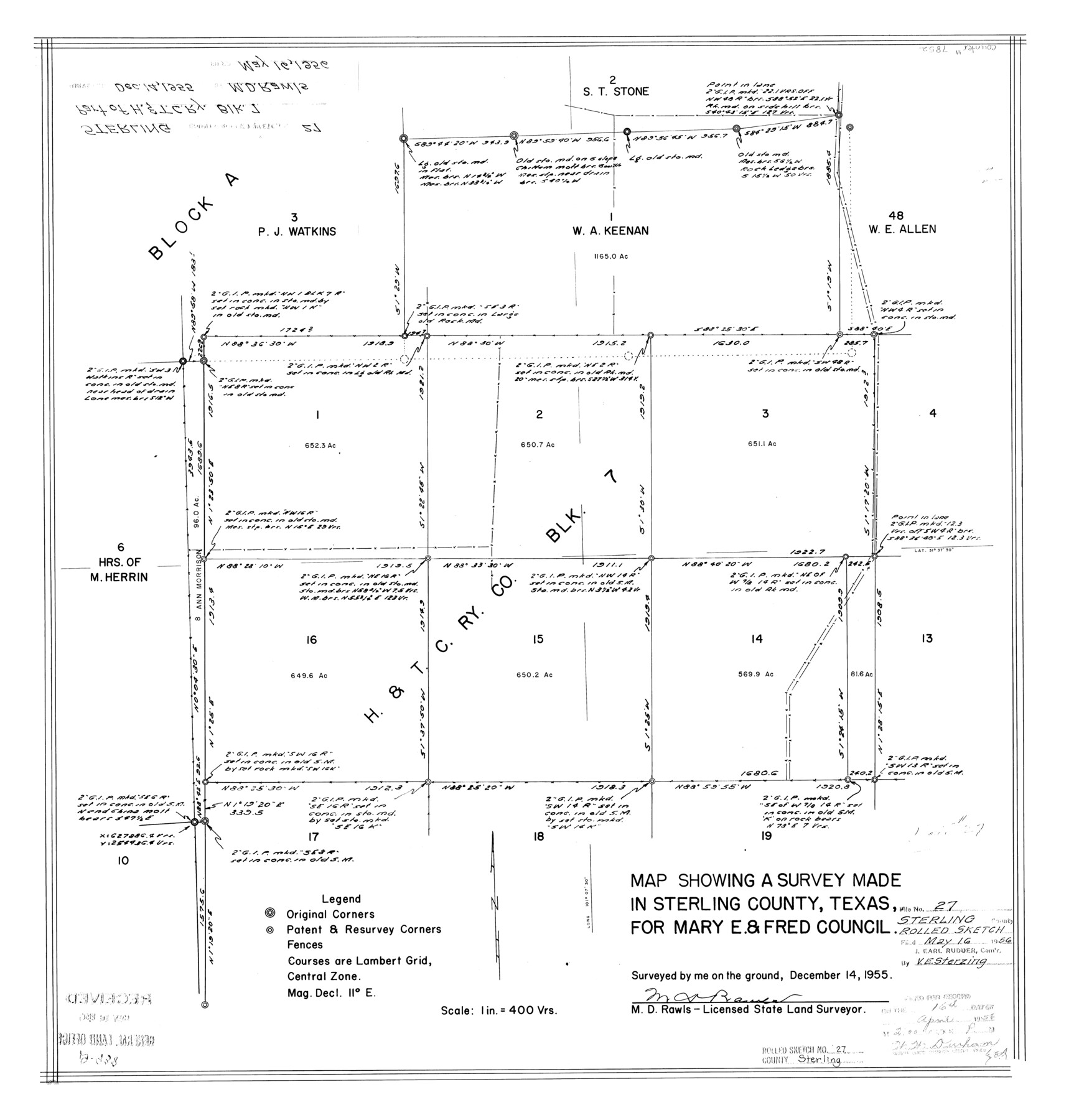
Sterling County Rolled Sketch 27
Map showing a survey made in Sterling County, Texas for Mary E. & Fred Council
-
Map/Doc
7852
-
Collection
General Map Collection
-
Object Dates
1955/12/14 (Survey Date)
1956/5/16 (File Date)
-
People and Organizations
M.D. Rawls (Surveyor/Engineer)
-
Counties
Sterling
-
Subjects
Surveying Rolled Sketch
-
Height x Width
24.0 x 23.2 inches
61.0 x 58.9 cm
-
Medium
mylar, print
-
Scale
1" = 400 varas
Part of: General Map Collection
Liberty County Working Sketch 32

Print $20.00
- Digital $50.00
Liberty County Working Sketch 32
1945
Size 29.1 x 46.3 inches
Map/Doc 70491
Cottle County Working Sketch Graphic Index

Print $20.00
- Digital $50.00
Cottle County Working Sketch Graphic Index
1971
Size 41.8 x 33.8 inches
Map/Doc 76506
Ector County Rolled Sketch HLG

Print $20.00
- Digital $50.00
Ector County Rolled Sketch HLG
1937
Size 45.2 x 30.2 inches
Map/Doc 8835
Howard County Working Sketch 13

Print $20.00
- Digital $50.00
Howard County Working Sketch 13
1983
Size 33.3 x 37.3 inches
Map/Doc 66281
Hartley County Working Sketch 2

Print $20.00
- Digital $50.00
Hartley County Working Sketch 2
1920
Size 41.8 x 30.7 inches
Map/Doc 66052
Stephens County Rolled Sketch 5

Print $20.00
- Digital $50.00
Stephens County Rolled Sketch 5
Size 23.2 x 37.2 inches
Map/Doc 7842
University Land Field Notes for Blocks 39, 41, 42, 44, 45, 46, 47, 50, and 51 in Crockett County, Blocks 38 and 40 in Crockett and Irion Counties, and Blocks 48 and 49 in Crockett and Reagan Counties, and Block 43 in Crockett, Irion, and Reagan Counties

University Land Field Notes for Blocks 39, 41, 42, 44, 45, 46, 47, 50, and 51 in Crockett County, Blocks 38 and 40 in Crockett and Irion Counties, and Blocks 48 and 49 in Crockett and Reagan Counties, and Block 43 in Crockett, Irion, and Reagan Counties
Map/Doc 81718
Grimes County Working Sketch 6

Print $20.00
- Digital $50.00
Grimes County Working Sketch 6
1951
Size 33.2 x 33.4 inches
Map/Doc 63297
Gray County Boundary File 2

Print $8.00
- Digital $50.00
Gray County Boundary File 2
Size 14.2 x 8.6 inches
Map/Doc 53850
Duval County Sketch File 6a

Print $20.00
- Digital $50.00
Duval County Sketch File 6a
1875
Size 10.9 x 22.9 inches
Map/Doc 11382
Loving County Working Sketch 14

Print $40.00
- Digital $50.00
Loving County Working Sketch 14
1957
Size 86.7 x 35.0 inches
Map/Doc 70647
Hudspeth County Rolled Sketch 50

Print $40.00
- Digital $50.00
Hudspeth County Rolled Sketch 50
1971
Size 56.6 x 34.8 inches
Map/Doc 9220
You may also like
Jeff Davis County Working Sketch 3

Print $20.00
- Digital $50.00
Jeff Davis County Working Sketch 3
1914
Size 17.8 x 16.9 inches
Map/Doc 66498
Mason County Working Sketch 14

Print $20.00
- Digital $50.00
Mason County Working Sketch 14
1959
Size 28.6 x 23.3 inches
Map/Doc 70850
Nueces County NRC Article 33.136 Location Key Sheet

Print $20.00
- Digital $50.00
Nueces County NRC Article 33.136 Location Key Sheet
1975
Size 27.0 x 23.0 inches
Map/Doc 88586
Cameron County State Real Property Sketch 2

Print $20.00
- Digital $50.00
Cameron County State Real Property Sketch 2
1996
Size 25.4 x 39.1 inches
Map/Doc 80132
Maverick County

Print $20.00
- Digital $50.00
Maverick County
1878
Size 33.4 x 21.4 inches
Map/Doc 3851
Dallas County Working Sketch 12

Print $20.00
- Digital $50.00
Dallas County Working Sketch 12
1983
Size 30.5 x 44.1 inches
Map/Doc 68578
Blanco County Boundary File 10

Print $26.00
- Digital $50.00
Blanco County Boundary File 10
Size 8.9 x 7.6 inches
Map/Doc 50576
Concho County Sketch File 27

Print $8.00
- Digital $50.00
Concho County Sketch File 27
1885
Size 11.3 x 8.8 inches
Map/Doc 19162
Right of Way and Track Map, Houston & Texas Central R.R. operated by the T. and N. O. R.R., Fort Worth Branch

Print $40.00
- Digital $50.00
Right of Way and Track Map, Houston & Texas Central R.R. operated by the T. and N. O. R.R., Fort Worth Branch
1918
Size 31.8 x 57.1 inches
Map/Doc 64781
Nolan County Working Sketch 10

Print $40.00
- Digital $50.00
Nolan County Working Sketch 10
1971
Size 78.9 x 37.0 inches
Map/Doc 71301
Map of Lavaca County

Print $20.00
- Digital $50.00
Map of Lavaca County
1884
Size 21.7 x 22.5 inches
Map/Doc 3804
Reeves County Rolled Sketch 23

Print $20.00
- Digital $50.00
Reeves County Rolled Sketch 23
1982
Size 19.6 x 25.5 inches
Map/Doc 7491