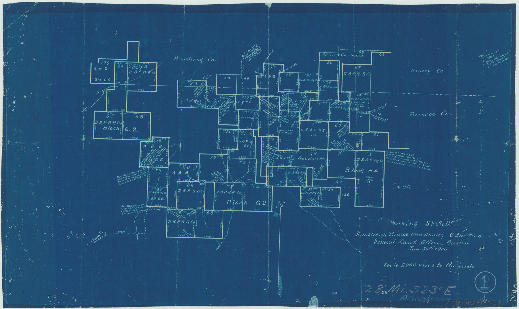
Armstrong County Working Sketch 1
-
Map/Doc
67232
-
Collection
General Map Collection
-
Object Dates
1/30/1903 (Creation Date)
-
Counties
Armstrong Briscoe Donley
-
Subjects
Surveying Working Sketch
-
Height x Width
10.3 x 17.2 inches
26.2 x 43.7 cm
-
Scale
1" = 2000 varas
-
Comments
Surveys located about 28 miles South 23 degrees East of Claude, Texas.
Part of: General Map Collection
Texas Gulf Coast from the Sabine River to the Rio Grande Showing Location of Navigation Districts

Print $20.00
- Digital $50.00
Texas Gulf Coast from the Sabine River to the Rio Grande Showing Location of Navigation Districts
1954
Size 45.0 x 43.8 inches
Map/Doc 73596
Duval County Working Sketch 12

Print $20.00
- Digital $50.00
Duval County Working Sketch 12
1937
Size 22.1 x 27.8 inches
Map/Doc 68725
Flight Mission No. DQN-1K, Frame 65, Calhoun County

Print $20.00
- Digital $50.00
Flight Mission No. DQN-1K, Frame 65, Calhoun County
1953
Size 18.5 x 22.2 inches
Map/Doc 84152
Mason County Sketch File 10

Print $6.00
- Digital $50.00
Mason County Sketch File 10
1885
Size 12.8 x 11.6 inches
Map/Doc 30693
Hudspeth County Working Sketch 28

Print $20.00
- Digital $50.00
Hudspeth County Working Sketch 28
1972
Size 29.2 x 31.3 inches
Map/Doc 66310
Blanco County Rolled Sketch 22

Print $20.00
- Digital $50.00
Blanco County Rolled Sketch 22
2007
Size 17.4 x 11.4 inches
Map/Doc 87926
Hudspeth County Working Sketch 13

Print $40.00
- Digital $50.00
Hudspeth County Working Sketch 13
1952
Size 34.3 x 51.4 inches
Map/Doc 66295
Panola County Sketch File 2

Print $4.00
- Digital $50.00
Panola County Sketch File 2
1851
Size 10.8 x 8.2 inches
Map/Doc 33447
Bosque County Rolled Sketch 1

Print $20.00
- Digital $50.00
Bosque County Rolled Sketch 1
1978
Size 36.4 x 38.6 inches
Map/Doc 8452
Lynn County Working Sketch 1

Print $20.00
- Digital $50.00
Lynn County Working Sketch 1
1945
Size 17.2 x 14.0 inches
Map/Doc 70671
Zapata County Working Sketch 17

Print $20.00
- Digital $50.00
Zapata County Working Sketch 17
1970
Size 30.0 x 19.4 inches
Map/Doc 62068
Wilbarger County Boundary File 1

Print $52.00
- Digital $50.00
Wilbarger County Boundary File 1
Size 8.9 x 5.6 inches
Map/Doc 59916
You may also like
Ector County Sketch File 1

Print $20.00
- Digital $50.00
Ector County Sketch File 1
1931
Size 17.1 x 18.0 inches
Map/Doc 11415

Edwards County Working Sketch 61

Print $20.00
- Digital $50.00
Edwards County Working Sketch 61
1954
Size 21.0 x 40.3 inches
Map/Doc 68937
El Paso County Rolled Sketch 52

Print $20.00
- Digital $50.00
El Paso County Rolled Sketch 52
1929
Size 18.4 x 24.3 inches
Map/Doc 5839
[Garza, Blanco, Uvalde, and Crosby County School Lands]
![91197, [Garza, Blanco, Uvalde, and Crosby County School Lands], Twichell Survey Records](https://historictexasmaps.com/wmedia_w700/maps/91197-1.tif.jpg)
Print $20.00
- Digital $50.00
[Garza, Blanco, Uvalde, and Crosby County School Lands]
1913
Size 14.7 x 16.6 inches
Map/Doc 91197
[Fragment, Jefferson Plotted]
![78352, [Fragment, Jefferson Plotted], General Map Collection](https://historictexasmaps.com/wmedia_w700/maps/78352.tif.jpg)
Print $2.00
- Digital $50.00
[Fragment, Jefferson Plotted]
Size 14.0 x 7.5 inches
Map/Doc 78352
Sutton County Sketch File 46

Print $4.00
- Digital $50.00
Sutton County Sketch File 46
1939
Size 11.3 x 8.8 inches
Map/Doc 37517
Collingsworth County Sketch File 6

Print $4.00
- Digital $50.00
Collingsworth County Sketch File 6
1896
Size 11.4 x 9.1 inches
Map/Doc 18882
Lubbock County Sketch File 8

Print $8.00
- Digital $50.00
Lubbock County Sketch File 8
1907
Size 11.1 x 8.5 inches
Map/Doc 30426
Winkler County

Print $20.00
- Digital $50.00
Winkler County
1932
Size 40.3 x 40.1 inches
Map/Doc 77462
Map of Shelby County

Print $20.00
- Digital $50.00
Map of Shelby County
1839
Size 24.5 x 25.7 inches
Map/Doc 4032
Freestone County Sketch File 16

Print $4.00
- Digital $50.00
Freestone County Sketch File 16
Size 6.4 x 8.7 inches
Map/Doc 23072