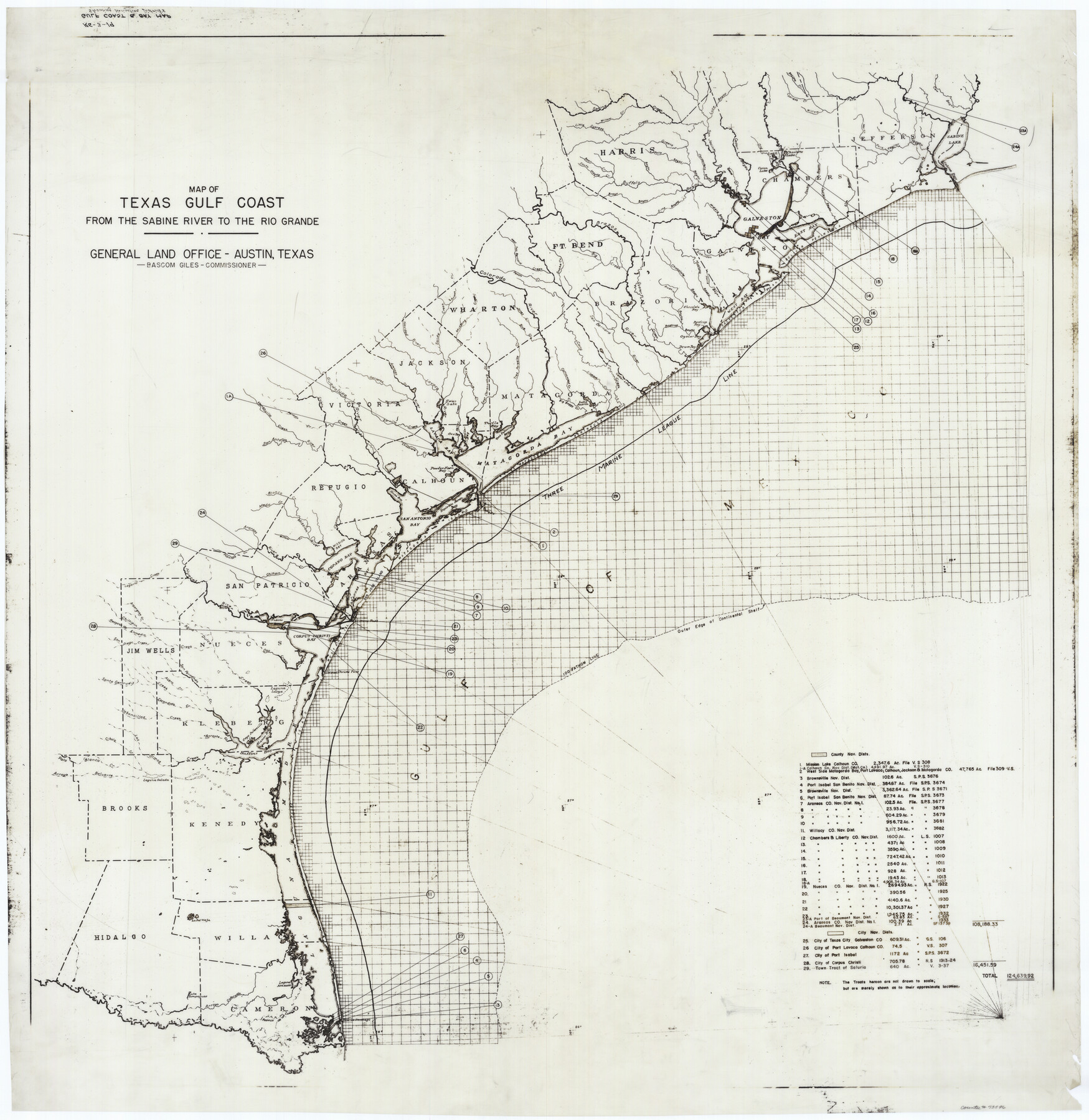
Texas Gulf Coast from the Sabine River to the Rio Grande Showing Location of Navigation Districts
Gulf Coast and Bay Map Showing Navigation Districts
-
Map/Doc
73596
-
Collection
General Map Collection
-
Object Dates
1954 (Creation Date)
-
People and Organizations
General Land Office (Publisher)
-
Counties
Orange Jefferson Chambers Galveston Brazoria
-
Subjects
Energy Offshore Submerged Area Gulf of Mexico
-
Height x Width
45.0 x 43.8 inches
114.3 x 111.3 cm
-
Scale
8 miles
-
Comments
Key map for Mineral Development showing Navigation Districts from the Sabine River to the Rio Grande. Coastline includes these counties: Orange, Jefferson, Chambers, Harris, Galveston, Brazoria, Matagorda, Calhoun, Refugio, Aransas, Nueces, Kleberg, Ken
Part of: General Map Collection
Howard County Boundary File 4b

Print $24.00
- Digital $50.00
Howard County Boundary File 4b
Size 11.3 x 8.9 inches
Map/Doc 55168
Henderson County

Print $40.00
- Digital $50.00
Henderson County
1897
Size 30.2 x 60.8 inches
Map/Doc 66859
Borden County Working Sketch 14

Print $20.00
- Digital $50.00
Borden County Working Sketch 14
1959
Size 27.8 x 25.2 inches
Map/Doc 67474
Flight Mission No. CUG-3P, Frame 30, Kleberg County

Print $20.00
- Digital $50.00
Flight Mission No. CUG-3P, Frame 30, Kleberg County
1956
Size 18.5 x 22.2 inches
Map/Doc 86235
Gaines County Sketch File 2M

Print $20.00
- Digital $50.00
Gaines County Sketch File 2M
1902
Size 20.8 x 29.4 inches
Map/Doc 11522
Terrell County Working Sketch 21

Print $20.00
- Digital $50.00
Terrell County Working Sketch 21
1935
Size 24.0 x 17.9 inches
Map/Doc 62171
Kendall County Working Sketch 16

Print $20.00
- Digital $50.00
Kendall County Working Sketch 16
1967
Size 28.0 x 29.1 inches
Map/Doc 66688
Tom Green County Sketch File 66

Print $22.00
- Digital $50.00
Tom Green County Sketch File 66
1929
Size 16.8 x 14.6 inches
Map/Doc 38236
Flight Mission No. BQR-9K, Frame 47, Brazoria County

Print $20.00
- Digital $50.00
Flight Mission No. BQR-9K, Frame 47, Brazoria County
1952
Size 18.7 x 22.4 inches
Map/Doc 84051
Map of the State of Texas [East Part]
![81920, Map of the State of Texas [East Part], General Map Collection](https://historictexasmaps.com/wmedia_w700/maps/81920.tif.jpg)
Print $40.00
- Digital $50.00
Map of the State of Texas [East Part]
1938
Size 67.8 x 37.3 inches
Map/Doc 81920
Webb County Working Sketch 33

Print $20.00
- Digital $50.00
Webb County Working Sketch 33
1938
Size 27.4 x 35.9 inches
Map/Doc 72398

You may also like
Map of Terry County

Print $20.00
- Digital $50.00
Map of Terry County
1917
Size 17.7 x 22.6 inches
Map/Doc 91874


Taylor County Working Sketch 13

Print $20.00
- Digital $50.00
Taylor County Working Sketch 13
1956
Size 16.3 x 28.9 inches
Map/Doc 69623
Railroad Track Map, H&TCRRCo., Falls County, Texas

Print $4.00
- Digital $50.00
Railroad Track Map, H&TCRRCo., Falls County, Texas
1918
Size 11.7 x 18.4 inches
Map/Doc 62862
Lubbock County Working Sketch 2

Print $20.00
- Digital $50.00
Lubbock County Working Sketch 2
Size 31.7 x 21.4 inches
Map/Doc 70661
Rio Grande, Penitas Sheet

Print $20.00
- Digital $50.00
Rio Grande, Penitas Sheet
1937
Size 40.2 x 42.9 inches
Map/Doc 65119
San Saba County Rolled Sketch 2

Print $20.00
- Digital $50.00
San Saba County Rolled Sketch 2
Size 38.9 x 20.7 inches
Map/Doc 7743
Map showing surveys in Blocks 45, 3, R & 5T

Print $20.00
- Digital $50.00
Map showing surveys in Blocks 45, 3, R & 5T
1913
Size 30.2 x 37.5 inches
Map/Doc 496
Fannin County Sketch File 20a

Print $7.00
- Digital $50.00
Fannin County Sketch File 20a
1889
Size 10.4 x 8.4 inches
Map/Doc 22482
County Map of Texas and Indian Territory

Print $20.00
- Digital $50.00
County Map of Texas and Indian Territory
1881
Size 13.1 x 9.9 inches
Map/Doc 94153
Eastland County Boundary File 26

Print $24.00
- Digital $50.00
Eastland County Boundary File 26
Size 7.8 x 3.5 inches
Map/Doc 52801