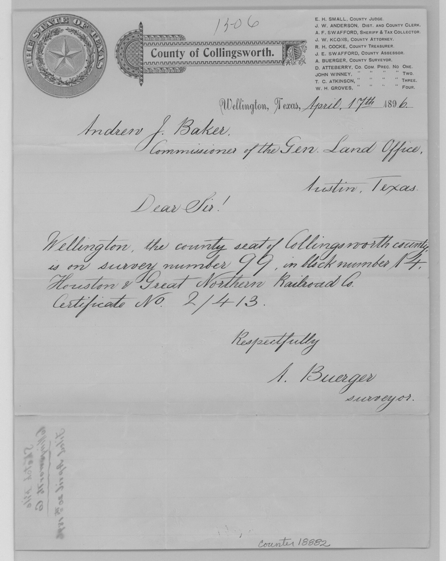
Collingsworth County Sketch File 6
[Letter regarding the location of the county seat]
-
Map/Doc
18882
-
Collection
General Map Collection
-
Object Dates
1896/4/17 (Creation Date)
1896/4/20 (File Date)
-
People and Organizations
A. Buerger (Surveyor/Engineer)
-
Counties
Collingsworth
-
Subjects
Surveying Sketch File
-
Height x Width
11.4 x 9.1 inches
29.0 x 23.1 cm
-
Medium
paper, manuscript
Part of: General Map Collection
Ward County Rolled Sketch A

Print $40.00
- Digital $50.00
Ward County Rolled Sketch A
Size 42.6 x 56.3 inches
Map/Doc 10099
Hudspeth County Working Sketch 15

Print $20.00
- Digital $50.00
Hudspeth County Working Sketch 15
1954
Size 36.4 x 16.2 inches
Map/Doc 66297
Flight Mission No. BRE-5P, Frame 191, Nueces County

Print $20.00
- Digital $50.00
Flight Mission No. BRE-5P, Frame 191, Nueces County
1956
Size 18.7 x 22.5 inches
Map/Doc 86837
Fractional Township No. 8 South Range No. 21 East of the Indian Meridian, Indian Territory

Print $20.00
- Digital $50.00
Fractional Township No. 8 South Range No. 21 East of the Indian Meridian, Indian Territory
1897
Size 19.2 x 24.2 inches
Map/Doc 75238
Colton's "New Medium" Map of the State of Texas, the Indian Territory, etc. from the latest & most authentic sources

Print $20.00
- Digital $50.00
Colton's "New Medium" Map of the State of Texas, the Indian Territory, etc. from the latest & most authentic sources
1884
Size 25.4 x 29.5 inches
Map/Doc 96524
Galveston County Rolled Sketch 40A

Print $20.00
- Digital $50.00
Galveston County Rolled Sketch 40A
1988
Size 42.0 x 46.0 inches
Map/Doc 9020
Wichita County

Print $20.00
- Digital $50.00
Wichita County
1971
Size 39.1 x 40.8 inches
Map/Doc 95673
Hardin County Rolled Sketch 15

Print $20.00
- Digital $50.00
Hardin County Rolled Sketch 15
1938
Size 30.9 x 23.7 inches
Map/Doc 6084
Wilbarger County Sketch File 18

Print $12.00
- Digital $50.00
Wilbarger County Sketch File 18
1886
Size 14.3 x 8.8 inches
Map/Doc 40209
Crockett County Working Sketch 38

Print $20.00
- Digital $50.00
Crockett County Working Sketch 38
1928
Size 28.7 x 16.6 inches
Map/Doc 68371
Harris County Working Sketch 64

Print $20.00
- Digital $50.00
Harris County Working Sketch 64
1954
Size 32.1 x 26.2 inches
Map/Doc 65956
Oldham County Sketch File 8

Print $4.00
- Digital $50.00
Oldham County Sketch File 8
Size 7.9 x 11.9 inches
Map/Doc 33239
You may also like
Hockley County Rolled Sketch 3

Print $40.00
- Digital $50.00
Hockley County Rolled Sketch 3
Size 82.9 x 29.4 inches
Map/Doc 9173
Upton County Rolled Sketch 42

Print $40.00
- Digital $50.00
Upton County Rolled Sketch 42
Size 26.5 x 55.9 inches
Map/Doc 10056
Rusk County Working Sketch 37c

Print $20.00
- Digital $50.00
Rusk County Working Sketch 37c
2007
Size 21.2 x 36.0 inches
Map/Doc 87498
The League Lines, Coastal and Border Reserves, with Surveys

Print $20.00
The League Lines, Coastal and Border Reserves, with Surveys
2020
Size 20.1 x 21.7 inches
Map/Doc 96426
Texas Intracoastal Waterway - Laguna Madre - Rincon de San Jose to Chubby Island

Print $20.00
- Digital $50.00
Texas Intracoastal Waterway - Laguna Madre - Rincon de San Jose to Chubby Island
1957
Size 38.9 x 27.3 inches
Map/Doc 73513
[Surveys along Childress Creek in Bosque County]
![69759, [Surveys along Childress Creek in Bosque County], General Map Collection](https://historictexasmaps.com/wmedia_w700/maps/69759.tif.jpg)
Print $2.00
- Digital $50.00
[Surveys along Childress Creek in Bosque County]
1846
Size 11.6 x 8.5 inches
Map/Doc 69759
Milam County Boundary File 2a

Print $10.00
- Digital $50.00
Milam County Boundary File 2a
Size 10.6 x 8.0 inches
Map/Doc 57208
Freestone County Working Sketch Graphic Index

Print $20.00
- Digital $50.00
Freestone County Working Sketch Graphic Index
1988
Size 43.0 x 42.1 inches
Map/Doc 76547
Flight Mission No. CGN-3P, Frame 23, San Patricio County

Print $20.00
- Digital $50.00
Flight Mission No. CGN-3P, Frame 23, San Patricio County
1956
Size 18.6 x 22.2 inches
Map/Doc 86981
[E. L. & R. R. Block 10]
![91352, [E. L. & R. R. Block 10], Twichell Survey Records](https://historictexasmaps.com/wmedia_w700/maps/91352-1.tif.jpg)
Print $20.00
- Digital $50.00
[E. L. & R. R. Block 10]
Size 25.6 x 15.8 inches
Map/Doc 91352
Newton County Working Sketch 26

Print $20.00
- Digital $50.00
Newton County Working Sketch 26
1953
Size 18.3 x 16.4 inches
Map/Doc 71272
Travis County Working Sketch 20

Print $20.00
- Digital $50.00
Travis County Working Sketch 20
1945
Size 28.5 x 31.9 inches
Map/Doc 69404