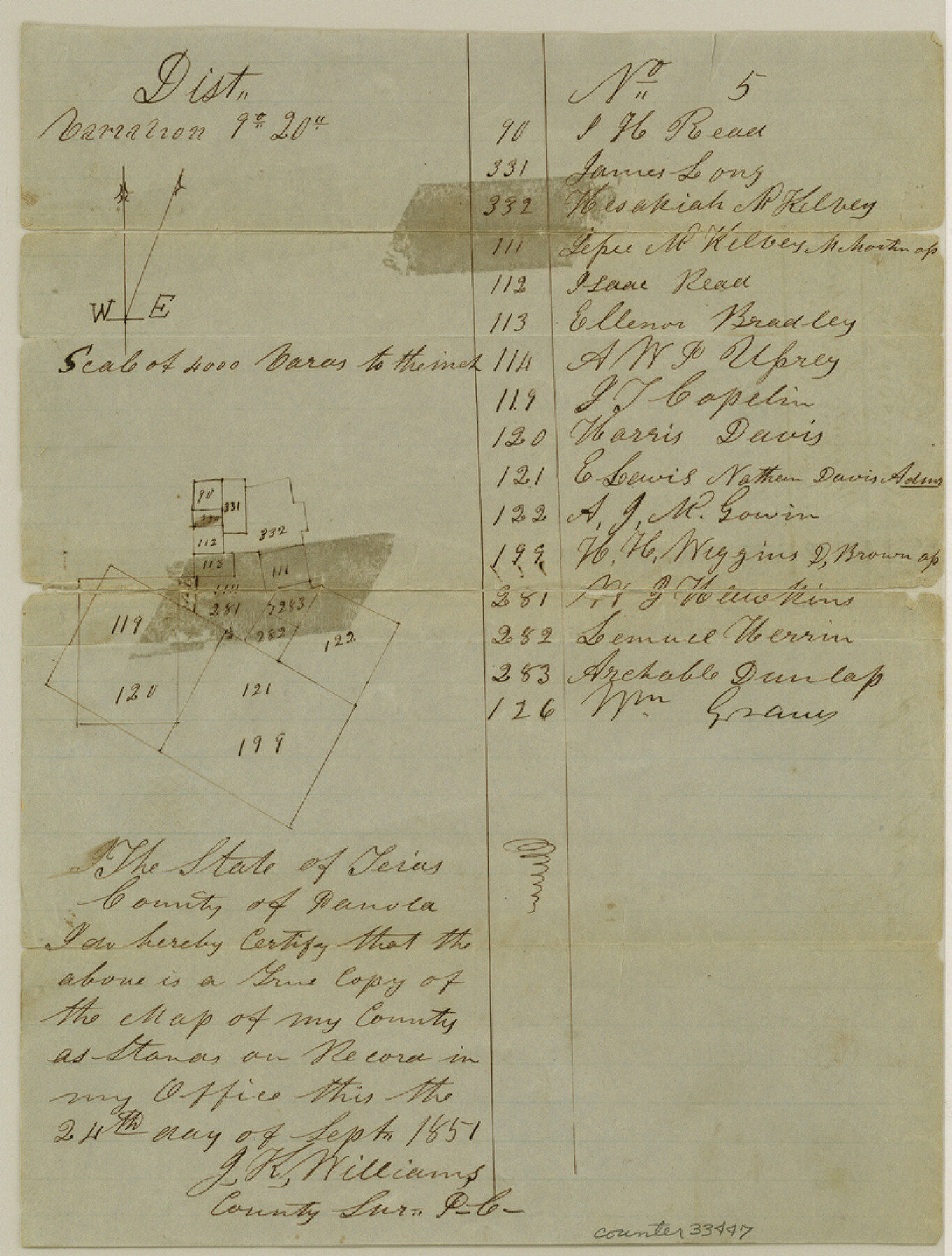
Panola County Sketch File 2
[Sketch in southwest part of county]
-
Map/Doc
33447
-
Collection
General Map Collection
-
Object Dates
9/24/1851 (Creation Date)
10/1851 (File Date)
-
People and Organizations
J.K. Williams (Surveyor/Engineer)
-
Counties
Panola
-
Subjects
Surveying Sketch File
-
Height x Width
10.8 x 8.2 inches
27.4 x 20.8 cm
-
Medium
paper, manuscript
-
Scale
1" = 4000 varas
Part of: General Map Collection
Bandera County Working Sketch 60

Print $20.00
- Digital $50.00
Bandera County Working Sketch 60
2004
Size 32.1 x 43.6 inches
Map/Doc 83562
Wichita County Sketch File 35

Print $8.00
- Digital $50.00
Wichita County Sketch File 35
1950
Size 14.3 x 8.5 inches
Map/Doc 40157
Brewster County Sketch File N-2

Print $44.00
- Digital $50.00
Brewster County Sketch File N-2
1881
Size 8.2 x 12.8 inches
Map/Doc 15567
San Jacinto County

Print $40.00
- Digital $50.00
San Jacinto County
1942
Size 48.7 x 43.1 inches
Map/Doc 73282
Bexar County Sketch File 49

Print $8.00
- Digital $50.00
Bexar County Sketch File 49
1874
Size 12.6 x 8.3 inches
Map/Doc 14530
Map of Nacogdoches County

Print $20.00
- Digital $50.00
Map of Nacogdoches County
1881
Size 24.1 x 21.5 inches
Map/Doc 4605
Travis County Working Sketch 21

Print $20.00
- Digital $50.00
Travis County Working Sketch 21
1946
Size 35.6 x 42.7 inches
Map/Doc 69405
Flight Mission No. CRC-4R, Frame 150, Chambers County

Print $20.00
- Digital $50.00
Flight Mission No. CRC-4R, Frame 150, Chambers County
1956
Size 18.6 x 22.4 inches
Map/Doc 84913
Dickens County Sketch File 19

Print $4.00
- Digital $50.00
Dickens County Sketch File 19
1910
Size 8.4 x 7.5 inches
Map/Doc 20982
Potter County Sketch File 12

Print $4.00
- Digital $50.00
Potter County Sketch File 12
1890
Size 6.0 x 8.7 inches
Map/Doc 34399
Flight Mission No. DQN-7K, Frame 13, Calhoun County

Print $20.00
- Digital $50.00
Flight Mission No. DQN-7K, Frame 13, Calhoun County
1953
Size 18.4 x 22.1 inches
Map/Doc 84464
Uvalde County Rolled Sketch A

Print $20.00
- Digital $50.00
Uvalde County Rolled Sketch A
1849
Size 21.7 x 25.8 inches
Map/Doc 8104
You may also like
El Paso County Rolled Sketch 50

Print $20.00
- Digital $50.00
El Paso County Rolled Sketch 50
1956
Size 18.9 x 26.7 inches
Map/Doc 5835
Angelina County Sketch File 23a

Print $4.00
- Digital $50.00
Angelina County Sketch File 23a
1904
Size 11.2 x 8.6 inches
Map/Doc 13063
Starr County Rolled Sketch 24

Print $20.00
- Digital $50.00
Starr County Rolled Sketch 24
1938
Size 37.5 x 26.7 inches
Map/Doc 7808
Medina County Working Sketch 24

Print $20.00
- Digital $50.00
Medina County Working Sketch 24
1984
Size 26.1 x 36.7 inches
Map/Doc 70939
Borden County Working Sketch Graphic Index

Print $20.00
- Digital $50.00
Borden County Working Sketch Graphic Index
1977
Size 45.7 x 34.8 inches
Map/Doc 76468
Navarro County Working Sketch 2

Print $20.00
- Digital $50.00
Navarro County Working Sketch 2
1922
Size 21.9 x 22.2 inches
Map/Doc 71232
Tyler County Rolled Sketch 4

Print $20.00
- Digital $50.00
Tyler County Rolled Sketch 4
1952
Size 38.9 x 44.0 inches
Map/Doc 10028
General Highway Map, Duval County, Texas

Print $20.00
General Highway Map, Duval County, Texas
1961
Size 18.1 x 24.5 inches
Map/Doc 79449
Hunt County Rolled Sketch 5

Print $20.00
- Digital $50.00
Hunt County Rolled Sketch 5
1956
Size 27.6 x 24.8 inches
Map/Doc 6270
Dallam County

Print $40.00
- Digital $50.00
Dallam County
1926
Size 39.9 x 48.6 inches
Map/Doc 95474
Webb County Working Sketch 71

Print $40.00
- Digital $50.00
Webb County Working Sketch 71
1973
Size 46.1 x 95.8 inches
Map/Doc 72438
Concho County Sketch File 29

Print $12.00
- Digital $50.00
Concho County Sketch File 29
1886
Size 11.7 x 9.0 inches
Map/Doc 19169