Lubbock County Sketch File 8
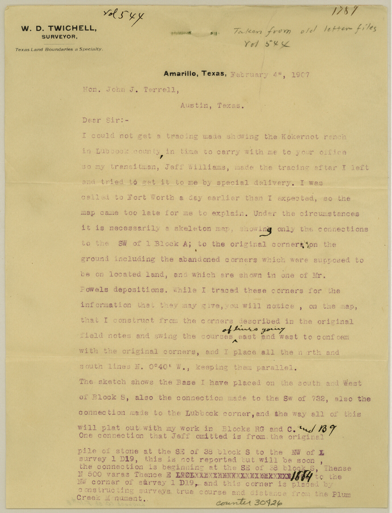
[Letter from W. D. Twichell to John J. Terrell]
-
Map/Doc
30426
-
Collection
General Map Collection
-
Object Dates
2/4/1907 (Creation Date)
2/4/1907 (Correspondence Date)
-
People and Organizations
W.D. Twichell (Surveyor/Engineer)
-
Counties
Lubbock
-
Subjects
Surveying Sketch File
-
Height x Width
11.1 x 8.5 inches
28.2 x 21.6 cm
-
Medium
paper, print
-
Features
Kokernot Ranch
Plum Creek
Bassett Ranch
Jno. B. Slaughter Ranch
Double Mountain
Part of: General Map Collection
Jasper County Working Sketch 21

Print $20.00
- Digital $50.00
Jasper County Working Sketch 21
1941
Size 13.1 x 21.4 inches
Map/Doc 66483
Sherman County Boundary File 3

Print $55.00
- Digital $50.00
Sherman County Boundary File 3
Size 9.2 x 8.6 inches
Map/Doc 58773
Coleman County Rolled Sketch 2

Print $20.00
- Digital $50.00
Coleman County Rolled Sketch 2
Size 18.3 x 24.9 inches
Map/Doc 5528
Map of Swisher County

Print $20.00
- Digital $50.00
Map of Swisher County
1898
Size 36.4 x 32.7 inches
Map/Doc 16889
Schleicher County Rolled Sketch 5

Print $20.00
- Digital $50.00
Schleicher County Rolled Sketch 5
Size 19.3 x 23.8 inches
Map/Doc 7748
Bell County Working Sketch 13

Print $20.00
- Digital $50.00
Bell County Working Sketch 13
1964
Size 19.6 x 18.5 inches
Map/Doc 67353
Flight Mission No. DQO-3K, Frame 79, Galveston County

Print $20.00
- Digital $50.00
Flight Mission No. DQO-3K, Frame 79, Galveston County
1952
Size 18.9 x 22.5 inches
Map/Doc 85084
Map of Austin County

Print $20.00
- Digital $50.00
Map of Austin County
1863
Size 25.7 x 29.8 inches
Map/Doc 3253
Flight Mission No. DIX-8P, Frame 69, Aransas County

Print $20.00
- Digital $50.00
Flight Mission No. DIX-8P, Frame 69, Aransas County
1956
Size 18.7 x 22.4 inches
Map/Doc 83900
King County Sketch File 7A

Print $28.00
- Digital $50.00
King County Sketch File 7A
1902
Size 22.1 x 34.7 inches
Map/Doc 11936
Nueces County Sketch File 54

Print $4.00
- Digital $50.00
Nueces County Sketch File 54
1856
Size 12.7 x 8.1 inches
Map/Doc 32865
Cass County Sketch File 1

Print $4.00
- Digital $50.00
Cass County Sketch File 1
1857
Size 11.6 x 8.2 inches
Map/Doc 17392
You may also like
[E. L. & R. R. RR. Company, Block LC2]
![90663, [E. L. & R. R. RR. Company, Block LC2], Twichell Survey Records](https://historictexasmaps.com/wmedia_w700/maps/90663-1.tif.jpg)
Print $2.00
- Digital $50.00
[E. L. & R. R. RR. Company, Block LC2]
1907
Size 9.7 x 7.9 inches
Map/Doc 90663
La Salle County Working Sketch 34

Print $20.00
- Digital $50.00
La Salle County Working Sketch 34
1956
Size 18.8 x 26.2 inches
Map/Doc 70335
Presidio County Working Sketch 146

Print $20.00
- Digital $50.00
Presidio County Working Sketch 146
1989
Size 20.7 x 20.6 inches
Map/Doc 71824
A map of the Anthracite Coal Fields of Pennsylvania embracing all of Schuylkill County and parts of Carbon, Luzerne, Columbia, Northumberland, Dauphin, and Lebanon Counties

Print $20.00
- Digital $50.00
A map of the Anthracite Coal Fields of Pennsylvania embracing all of Schuylkill County and parts of Carbon, Luzerne, Columbia, Northumberland, Dauphin, and Lebanon Counties
1863
Size 27.1 x 39.3 inches
Map/Doc 94054
Bastrop County Working Sketch 16

Print $20.00
- Digital $50.00
Bastrop County Working Sketch 16
1998
Size 39.2 x 34.1 inches
Map/Doc 67316
Flight Mission No. DCL-7C, Frame 20, Kenedy County

Print $20.00
- Digital $50.00
Flight Mission No. DCL-7C, Frame 20, Kenedy County
1943
Size 15.5 x 15.1 inches
Map/Doc 86012
Map of Leon County

Print $20.00
- Digital $50.00
Map of Leon County
1871
Size 23.6 x 21.2 inches
Map/Doc 3808
From the Red River to the Rio Grande from explorations and surveys made under the direction of the Hon. Jefferson Davis, Secretary of War by Captain John Pope, Corps Topl. Engrs. assisted by Lieutenant Kenner Gerrard, 1st Dragoons, 1854-6

Print $40.00
From the Red River to the Rio Grande from explorations and surveys made under the direction of the Hon. Jefferson Davis, Secretary of War by Captain John Pope, Corps Topl. Engrs. assisted by Lieutenant Kenner Gerrard, 1st Dragoons, 1854-6
1859
Size 28.0 x 57.9 inches
Map/Doc 93581
Travis County Working Sketch 39

Print $20.00
- Digital $50.00
Travis County Working Sketch 39
1974
Size 33.1 x 31.7 inches
Map/Doc 69423
Sterling County Rolled Sketch 21

Print $20.00
- Digital $50.00
Sterling County Rolled Sketch 21
Size 29.6 x 23.8 inches
Map/Doc 7849
Flight Mission No. CLL-1N, Frame 30, Willacy County

Print $20.00
- Digital $50.00
Flight Mission No. CLL-1N, Frame 30, Willacy County
1954
Size 18.4 x 22.2 inches
Map/Doc 87011
Shackelford County Sketch File 4

Print $40.00
- Digital $50.00
Shackelford County Sketch File 4
Size 38.5 x 53.7 inches
Map/Doc 10600