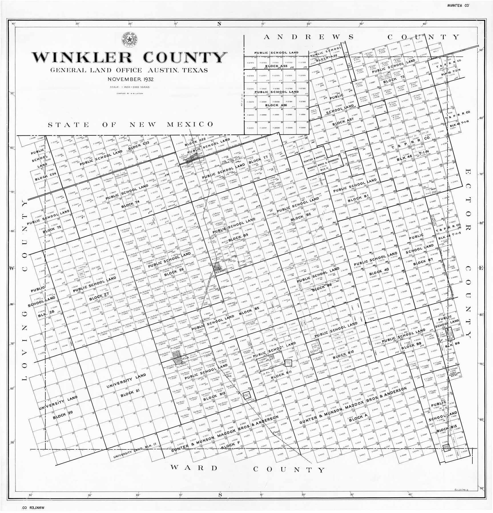
Winkler County
-
Map/Doc
77462
-
Collection
General Map Collection
-
Object Dates
11/1932 (Creation Date)
-
People and Organizations
W.W. Latson (Compiler)
W.M. Beck (Draftsman)
-
Counties
Winkler
-
Subjects
County
-
Height x Width
40.3 x 40.1 inches
102.4 x 101.9 cm
Part of: General Map Collection
Hardeman County Boundary File 4

Print $142.00
- Digital $50.00
Hardeman County Boundary File 4
Size 24.0 x 18.2 inches
Map/Doc 54392
San Jacinto County Rolled Sketch 14

Print $20.00
- Digital $50.00
San Jacinto County Rolled Sketch 14
1998
Size 29.0 x 40.6 inches
Map/Doc 7567
Map of Dallas County

Print $20.00
- Digital $50.00
Map of Dallas County
1871
Size 22.1 x 18.7 inches
Map/Doc 3463
Jones County Working Sketch 5

Print $20.00
- Digital $50.00
Jones County Working Sketch 5
1950
Size 35.5 x 29.3 inches
Map/Doc 66643
[Sketch showing University Lands in West Texas]
![62964, [Sketch showing University Lands in West Texas], General Map Collection](https://historictexasmaps.com/wmedia_w700/maps/62964-1.tif.jpg)
Print $20.00
- Digital $50.00
[Sketch showing University Lands in West Texas]
Size 20.5 x 27.8 inches
Map/Doc 62964
Jefferson County Rolled Sketch 12

Print $2.00
- Digital $50.00
Jefferson County Rolled Sketch 12
Size 10.6 x 8.2 inches
Map/Doc 76004
Brazoria County Working Sketch 17

Print $20.00
- Digital $50.00
Brazoria County Working Sketch 17
1948
Size 17.0 x 19.0 inches
Map/Doc 67502
Flight Mission No. DCL-7C, Frame 123, Kenedy County

Print $20.00
- Digital $50.00
Flight Mission No. DCL-7C, Frame 123, Kenedy County
1943
Size 18.5 x 22.2 inches
Map/Doc 86088
Presidio County Rolled Sketch T-4

Print $20.00
- Digital $50.00
Presidio County Rolled Sketch T-4
1949
Size 32.1 x 15.7 inches
Map/Doc 7418
El Paso County Sketch File 19

Print $30.00
- Digital $50.00
El Paso County Sketch File 19
1905
Size 13.3 x 8.7 inches
Map/Doc 22009
Flight Mission No. BRE-2P, Frame 97, Nueces County

Print $20.00
- Digital $50.00
Flight Mission No. BRE-2P, Frame 97, Nueces County
1956
Size 18.5 x 22.3 inches
Map/Doc 86782
Matagorda County NRC Article 33.136 Sketch 12

Print $32.00
- Digital $50.00
Matagorda County NRC Article 33.136 Sketch 12
2017
Size 22.0 x 34.0 inches
Map/Doc 94780
You may also like
Henderson County Rolled Sketch 11

Print $20.00
- Digital $50.00
Henderson County Rolled Sketch 11
1915
Size 29.5 x 42.5 inches
Map/Doc 75960
Terrell County Rolled Sketch 57

Print $20.00
- Digital $50.00
Terrell County Rolled Sketch 57
1986
Size 33.0 x 25.2 inches
Map/Doc 7974
Dallas County Sketch File 16

Print $4.00
- Digital $50.00
Dallas County Sketch File 16
Size 8.0 x 8.4 inches
Map/Doc 20435
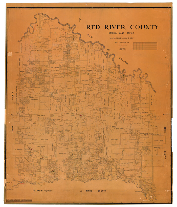
Red River County
Print $20.00
- Digital $50.00
Red River County
1934
Size 47.0 x 40.2 inches
Map/Doc 95623

Pecos County Rolled Sketch 122

Print $20.00
- Digital $50.00
Pecos County Rolled Sketch 122
1945
Size 32.5 x 39.1 inches
Map/Doc 7263
Wichita County Sketch File E

Print $40.00
- Digital $50.00
Wichita County Sketch File E
Size 14.2 x 15.6 inches
Map/Doc 40072
Carta General de la Republica Mexicana

Print $20.00
- Digital $50.00
Carta General de la Republica Mexicana
Size 23.1 x 31.1 inches
Map/Doc 96983
Throckmorton County Rolled Sketch 5

Print $20.00
- Digital $50.00
Throckmorton County Rolled Sketch 5
2001
Size 25.0 x 35.9 inches
Map/Doc 76405
Maps of Gulf Intracoastal Waterway, Texas - Sabine River to the Rio Grande and connecting waterways including ship channels

Print $20.00
- Digital $50.00
Maps of Gulf Intracoastal Waterway, Texas - Sabine River to the Rio Grande and connecting waterways including ship channels
1966
Size 14.5 x 22.2 inches
Map/Doc 61973
[Coleman and McCullogh County Drilling Block]
![92968, [Coleman and McCullogh County Drilling Block], Twichell Survey Records](https://historictexasmaps.com/wmedia_w700/maps/92968-1.tif.jpg)
Print $20.00
- Digital $50.00
[Coleman and McCullogh County Drilling Block]
Size 16.6 x 18.6 inches
Map/Doc 92968
Reeves County

Print $40.00
- Digital $50.00
Reeves County
1945
Size 48.6 x 39.6 inches
Map/Doc 63001