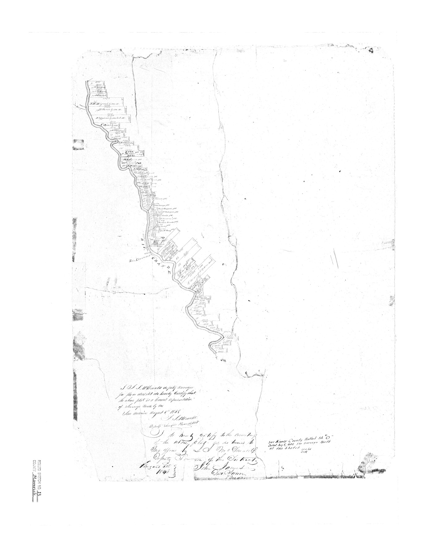
Maverick County Rolled Sketch 13
Sketch Along the Rio Grande River, Maverick County, Texas
- 
                          Map/Doc
6706
 - 
                            Collection
General Map Collection
 - 
                            Object Dates
1848/8/5 (Creation Date)
 - 
                            People and Organizations
J.S. McDonald (Surveyor/Engineer)
 - 
                            Counties
Maverick
 - 
                            Subjects
Surveying Rolled Sketch
 - 
                            Height x Width
34.4 x 26.5 inches
87.4 x 67.3 cm
 - 
                            Comments
See Kinney County Rolled Sketch O (6547) for sketch along Rio Grande to the north.
 
Related maps
            Kinney County Rolled Sketch O


                                            Print $20.00                    
                                             -                         Digital $50.00                                    
                Kinney County Rolled Sketch O
1848
Size 32.1 x 36.2 inches
                                Map/Doc 6547
            Part of: General Map Collection
            Nueces County Rolled Sketch 108


                                            Print $62.00                    
                                    
                Nueces County Rolled Sketch 108
1987
Size 18.6 x 23.5 inches
                                Map/Doc 7112
            
            Jasper County Sketch File 36


                                            Print $32.00                    
                                             -                         Digital $50.00                                    
                Jasper County Sketch File 36
1987
Size 11.2 x 8.6 inches
                                Map/Doc 27872
            
            Newton County Rolled Sketch 28


                                            Print $373.00                    
                                             -                         Digital $50.00                                    
                Newton County Rolled Sketch 28
1938
Size 10.3 x 15.4 inches
                                Map/Doc 47418
            
            Flight Mission No. BRA-16M, Frame 107, Jefferson County


                                            Print $20.00                    
                                             -                         Digital $50.00                                    
                Flight Mission No. BRA-16M, Frame 107, Jefferson County
1953
Size 18.5 x 22.3 inches
                                Map/Doc 85719
            
            Hardin County Sketch File 31


                                            Print $2.00                    
                                             -                         Digital $50.00                                    
                Hardin County Sketch File 31
Size 8.5 x 7.1 inches
                                Map/Doc 25162
            
            Tarrant County Working Sketch 15


                                            Print $20.00                    
                                             -                         Digital $50.00                                    
                Tarrant County Working Sketch 15
1989
Size 33.0 x 38.3 inches
                                Map/Doc 62432
            
            Tyler County Rolled Sketch 4


                                            Print $20.00                    
                                             -                         Digital $50.00                                    
                Tyler County Rolled Sketch 4
1952
Size 38.9 x 44.0 inches
                                Map/Doc 10028
            
            Val Verde County Working Sketch 84


                                            Print $20.00                    
                                             -                         Digital $50.00                                    
                Val Verde County Working Sketch 84
1973
Size 45.4 x 33.0 inches
                                Map/Doc 72219
            
            Liberty County Sketch File 68


                                            Print $24.00                    
                                             -                         Digital $50.00                                    
                Liberty County Sketch File 68
Size 11.0 x 8.5 inches
                                Map/Doc 94021
            
            Flight Mission No. CLL-1N, Frame 10, Willacy County


                                            Print $20.00                    
                                             -                         Digital $50.00                                    
                Flight Mission No. CLL-1N, Frame 10, Willacy County
1954
Size 18.5 x 22.1 inches
                                Map/Doc 86997
            
            Coke County Rolled Sketch 14


                                            Print $20.00                    
                                             -                         Digital $50.00                                    
                Coke County Rolled Sketch 14
Size 26.8 x 18.9 inches
                                Map/Doc 5514
            You may also like
            Ochiltree County Working Sketch 2


                                            Print $20.00                    
                                             -                         Digital $50.00                                    
                Ochiltree County Working Sketch 2
1959
Size 23.9 x 20.8 inches
                                Map/Doc 71315
            
            Colton's Map of the United States of America


                                            Print $20.00                    
                                             -                         Digital $50.00                                    
                Colton's Map of the United States of America
1866
Size 21.3 x 36.7 inches
                                Map/Doc 93642
            
            Flight Mission No. BRA-7M, Frame 85, Jefferson County


                                            Print $20.00                    
                                             -                         Digital $50.00                                    
                Flight Mission No. BRA-7M, Frame 85, Jefferson County
1953
Size 18.7 x 22.4 inches
                                Map/Doc 85507
            
            Sutton County Working Sketch 42


                                            Print $20.00                    
                                             -                         Digital $50.00                                    
                Sutton County Working Sketch 42
1950
Size 34.5 x 29.1 inches
                                Map/Doc 62385
            
            Shackelford County Boundary File 4


                                            Print $2.00                    
                                             -                         Digital $50.00                                    
                Shackelford County Boundary File 4
Size 6.6 x 8.8 inches
                                Map/Doc 58660
            
            Flight Mission No. DAG-23K, Frame 178, Matagorda County


                                            Print $20.00                    
                                             -                         Digital $50.00                                    
                Flight Mission No. DAG-23K, Frame 178, Matagorda County
1953
Size 18.8 x 22.5 inches
                                Map/Doc 86513
            
            General Highway Map, Terry County, Texas


                                            Print $20.00                    
                                    
                General Highway Map, Terry County, Texas
1961
Size 18.1 x 24.9 inches
                                Map/Doc 79675
            
            Webb County Rolled Sketch 7


                                            Print $20.00                    
                                             -                         Digital $50.00                                    
                Webb County Rolled Sketch 7
Size 29.1 x 43.7 inches
                                Map/Doc 8173
            
            General Highway Map, Garza County, Texas


                                            Print $20.00                    
                                    
                General Highway Map, Garza County, Texas
1940
Size 18.1 x 24.6 inches
                                Map/Doc 79098
            
            Plat Showing Proposed Dam & Reservoir Under Application No. 561 Located at Mouth of Clear Fork of Brazos River


                                            Print $20.00                    
                                             -                         Digital $50.00                                    
                Plat Showing Proposed Dam & Reservoir Under Application No. 561 Located at Mouth of Clear Fork of Brazos River
1921
Size 24.0 x 16.6 inches
                                Map/Doc 92094
            
            Brooks County Boundary File Index


                                            Print $2.00                    
                                             -                         Digital $50.00                                    
                Brooks County Boundary File Index
Size 8.6 x 3.1 inches
                                Map/Doc 50808
            
            Lamb County Working Sketch 2


                                            Print $20.00                    
                                             -                         Digital $50.00                                    
                Lamb County Working Sketch 2
1919
Size 13.6 x 15.3 inches
                                Map/Doc 70275