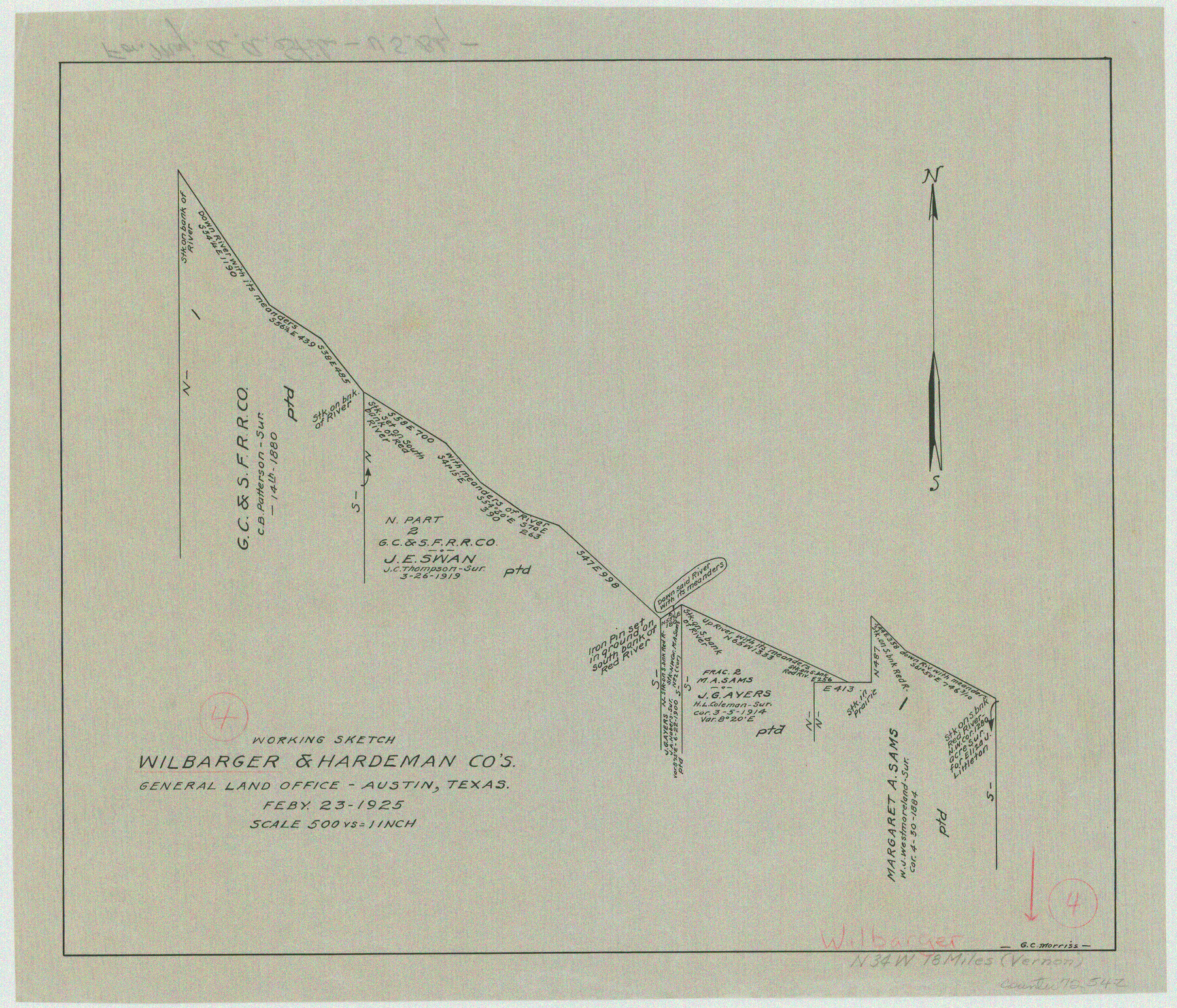
Wilbarger County Working Sketch 4
-
Map/Doc
72542
-
Collection
General Map Collection
-
Object Dates
2/23/1925 (Creation Date)
-
People and Organizations
G.C. Morriss (Draftsman)
-
Counties
Wilbarger Hardeman
-
Subjects
Surveying Working Sketch
-
Height x Width
14.6 x 17.1 inches
37.1 x 43.4 cm
-
Scale
1" = 500 varas
Part of: General Map Collection
Flight Mission No. DQO-8K, Frame 143, Galveston County

Print $20.00
- Digital $50.00
Flight Mission No. DQO-8K, Frame 143, Galveston County
1952
Size 18.6 x 22.5 inches
Map/Doc 85205

Flight Mission No. CLL-1N, Frame 184, Willacy County

Print $20.00
- Digital $50.00
Flight Mission No. CLL-1N, Frame 184, Willacy County
1954
Size 18.4 x 22.1 inches
Map/Doc 87054
Presidio County Working Sketch 124

Print $20.00
- Digital $50.00
Presidio County Working Sketch 124
1984
Size 30.8 x 24.3 inches
Map/Doc 71802
Briscoe County Sketch File F

Print $40.00
- Digital $50.00
Briscoe County Sketch File F
1917
Size 20.9 x 19.3 inches
Map/Doc 76756
Current Miscellaneous File 113

Print $52.00
- Digital $50.00
Current Miscellaneous File 113
Size 23.8 x 17.1 inches
Map/Doc 74787
Kimble County Working Sketch 43

Print $20.00
- Digital $50.00
Kimble County Working Sketch 43
1949
Size 34.6 x 37.6 inches
Map/Doc 70111
El Paso County Working Sketch 22

Print $20.00
- Digital $50.00
El Paso County Working Sketch 22
1961
Size 21.6 x 20.0 inches
Map/Doc 69044
Erath County Sketch File 13a

Print $6.00
- Digital $50.00
Erath County Sketch File 13a
1872
Size 10.3 x 8.2 inches
Map/Doc 22287
La Salle County Rolled Sketch 19

Print $20.00
- Digital $50.00
La Salle County Rolled Sketch 19
1953
Size 31.8 x 30.0 inches
Map/Doc 6583
Flight Mission No. DAG-17K, Frame 120, Matagorda County

Print $20.00
- Digital $50.00
Flight Mission No. DAG-17K, Frame 120, Matagorda County
1952
Size 18.6 x 22.4 inches
Map/Doc 86340
Lubbock County Boundary File 11

Print $68.00
- Digital $50.00
Lubbock County Boundary File 11
Size 14.7 x 9.2 inches
Map/Doc 56583
You may also like
[River Secs. 68-73, Archer County School Land League 3 and surrounding surveys]
![90468, [River Secs. 68-73, Archer County School Land League 3 and surrounding surveys], Twichell Survey Records](https://historictexasmaps.com/wmedia_w700/maps/90468-1.tif.jpg)
Print $20.00
- Digital $50.00
[River Secs. 68-73, Archer County School Land League 3 and surrounding surveys]
Size 38.4 x 36.4 inches
Map/Doc 90468
Jeff Davis County Sketch File 45

Print $10.00
- Digital $50.00
Jeff Davis County Sketch File 45
1890
Size 14.0 x 8.5 inches
Map/Doc 28075
Pecos County Rolled Sketch 146A

Print $37.00
- Digital $50.00
Pecos County Rolled Sketch 146A
1957
Size 10.4 x 15.2 inches
Map/Doc 48396
Webb County Working Sketch 26

Print $20.00
- Digital $50.00
Webb County Working Sketch 26
1931
Size 17.9 x 18.4 inches
Map/Doc 72391
Armstrong County Working Sketch 2

Print $20.00
- Digital $50.00
Armstrong County Working Sketch 2
1904
Size 29.0 x 23.4 inches
Map/Doc 67233
Flight Mission No. DQN-2K, Frame 142, Calhoun County

Print $20.00
- Digital $50.00
Flight Mission No. DQN-2K, Frame 142, Calhoun County
1953
Size 16.3 x 16.0 inches
Map/Doc 84311
Harris County Rolled Sketch P4

Print $20.00
- Digital $50.00
Harris County Rolled Sketch P4
1920
Size 12.1 x 34.6 inches
Map/Doc 6143
Upshur County Rolled Sketch 3

Print $20.00
- Digital $50.00
Upshur County Rolled Sketch 3
1965
Size 35.3 x 30.0 inches
Map/Doc 8062
Walker County

Print $20.00
- Digital $50.00
Walker County
1944
Size 45.7 x 38.4 inches
Map/Doc 73314
Burleson County Sketch File 5

Print $4.00
- Digital $50.00
Burleson County Sketch File 5
Size 12.9 x 8.3 inches
Map/Doc 16649
[Galveston, Harrisburg & San Antonio from El Paso-Presidio county boundary to Presidio-Pecos county boundary]
![64716, [Galveston, Harrisburg & San Antonio from El Paso-Presidio county boundary to Presidio-Pecos county boundary], General Map Collection](https://historictexasmaps.com/wmedia_w700/maps/64716.tif.jpg)
Print $40.00
- Digital $50.00
[Galveston, Harrisburg & San Antonio from El Paso-Presidio county boundary to Presidio-Pecos county boundary]
Size 124.4 x 45.3 inches
Map/Doc 64716
