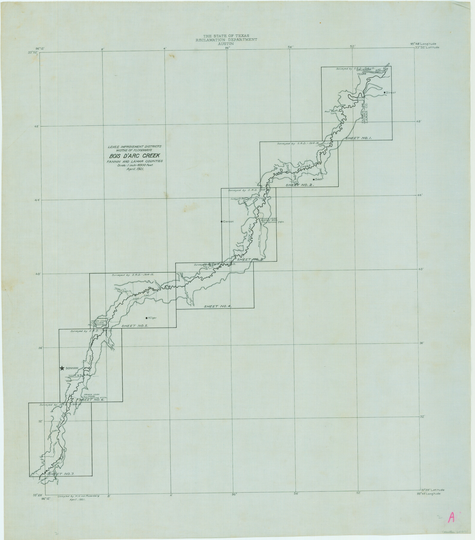
Red River, Levee Improvement Districts Widths of Floodways - Bois D'Arc Creek
-
Map/Doc
65271
-
Collection
General Map Collection
-
Object Dates
1921 (Creation Date)
-
People and Organizations
Texas State Reclamation Department (Publisher)
H.U. von Rosenberg (Compiler)
H.U. von Rosenberg (Draftsman)
-
Counties
Fannin Lamar
-
Subjects
River Surveys Topographic
-
Height x Width
29.5 x 26.0 inches
74.9 x 66.0 cm
Part of: General Map Collection
Flight Mission No. BRA-16M, Frame 174, Jefferson County

Print $20.00
- Digital $50.00
Flight Mission No. BRA-16M, Frame 174, Jefferson County
1953
Size 18.6 x 22.4 inches
Map/Doc 85772
Cameron County Rolled Sketch 18

Print $64.00
- Digital $50.00
Cameron County Rolled Sketch 18
1970
Size 48.9 x 57.1 inches
Map/Doc 8571
Map of Texas with population and location of principal towns and cities according to latest reliable statistics

Print $20.00
- Digital $50.00
Map of Texas with population and location of principal towns and cities according to latest reliable statistics
1908
Size 19.6 x 21.6 inches
Map/Doc 94068
El Paso County Working Sketch 30

Print $40.00
- Digital $50.00
El Paso County Working Sketch 30
1967
Size 32.0 x 65.8 inches
Map/Doc 69052
Presidio County Working Sketch 97

Print $20.00
- Digital $50.00
Presidio County Working Sketch 97
1978
Size 28.2 x 28.0 inches
Map/Doc 71774
Harrison County Sketch File 17

Print $4.00
- Digital $50.00
Harrison County Sketch File 17
1874
Size 8.8 x 10.5 inches
Map/Doc 26059
Sherman County Working Sketch Graphic Index

Print $20.00
- Digital $50.00
Sherman County Working Sketch Graphic Index
1932
Size 41.5 x 36.9 inches
Map/Doc 76698
Val Verde County

Print $20.00
- Digital $50.00
Val Verde County
1944
Size 40.8 x 37.7 inches
Map/Doc 78448
Orange County NRC Article 33.136 Sketch 1

Print $20.00
- Digital $50.00
Orange County NRC Article 33.136 Sketch 1
2004
Size 23.8 x 34.5 inches
Map/Doc 81979
Goliad County Working Sketch 4

Print $20.00
- Digital $50.00
Goliad County Working Sketch 4
1920
Size 30.5 x 30.0 inches
Map/Doc 63194
Calhoun County NRC Article 33.136 Sketch 3

Print $40.00
- Digital $50.00
Calhoun County NRC Article 33.136 Sketch 3
2000
Size 24.4 x 36.5 inches
Map/Doc 81914
Right of Way and Track Map Texas & New Orleans R.R. Co. operated by the T. & N. O. R.R. Co. Dallas-Sabine Branch

Print $40.00
- Digital $50.00
Right of Way and Track Map Texas & New Orleans R.R. Co. operated by the T. & N. O. R.R. Co. Dallas-Sabine Branch
1918
Size 26.4 x 56.7 inches
Map/Doc 64157
You may also like
Galveston County Rolled Sketch 18

Print $20.00
- Digital $50.00
Galveston County Rolled Sketch 18
1958
Size 24.1 x 32.0 inches
Map/Doc 5956

Potter County Working Sketch 3

Print $20.00
- Digital $50.00
Potter County Working Sketch 3
1920
Size 42.1 x 16.8 inches
Map/Doc 71663
Lynn County Rolled Sketch 11

Print $20.00
- Digital $50.00
Lynn County Rolled Sketch 11
1940
Size 14.2 x 16.4 inches
Map/Doc 6647
Sketch in Hardeman Co.

Print $20.00
- Digital $50.00
Sketch in Hardeman Co.
1890
Size 17.8 x 17.6 inches
Map/Doc 558
Bird's Eye View of Cuero, De Witt County, Texas

Print $20.00
Bird's Eye View of Cuero, De Witt County, Texas
1881
Size 18.4 x 25.5 inches
Map/Doc 89079
Texas Gulf Coast Sheets 1, 2, 3, 4. Map from the Sabine River to the Rio Grande As Subdivided for Mineral Development.

Print $40.00
- Digital $50.00
Texas Gulf Coast Sheets 1, 2, 3, 4. Map from the Sabine River to the Rio Grande As Subdivided for Mineral Development.
1966
Size 88.6 x 42.7 inches
Map/Doc 2903
Montgomery County Working Sketch 5

Print $20.00
- Digital $50.00
Montgomery County Working Sketch 5
1932
Size 31.6 x 37.0 inches
Map/Doc 71111
Grayson County Sketch File 3

Print $4.00
- Digital $50.00
Grayson County Sketch File 3
1855
Size 12.4 x 8.4 inches
Map/Doc 24460
Ector County Working Sketch 6

Print $20.00
- Digital $50.00
Ector County Working Sketch 6
1941
Size 47.5 x 22.5 inches
Map/Doc 68849
Map of Montague County

Print $20.00
- Digital $50.00
Map of Montague County
1868
Size 24.1 x 19.7 inches
Map/Doc 3887
Collingsworth County Working Sketch Graphic Index

Print $20.00
- Digital $50.00
Collingsworth County Working Sketch Graphic Index
1971
Size 41.0 x 34.8 inches
Map/Doc 76499