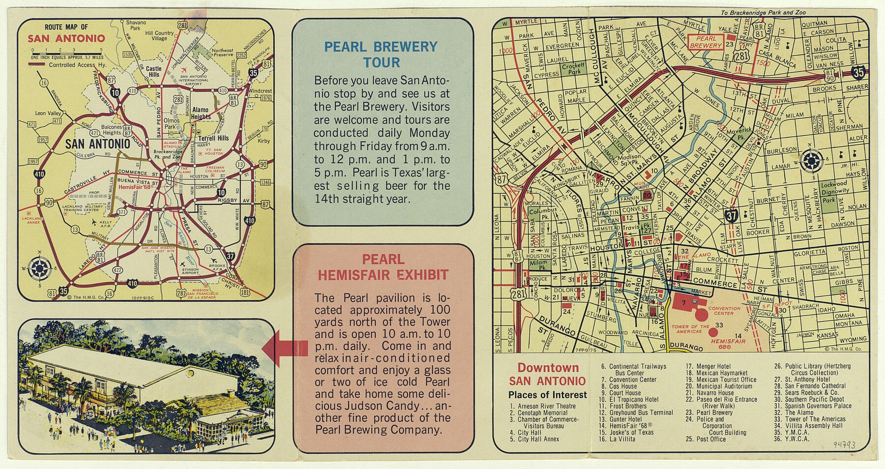
Map of Hemisfair '68 and Downtown San Antonio compliments of the Pearl Brewing Company
[verso]
-
Map/Doc
94793
-
Collection
General Map Collection
-
Object Dates
1968 (Creation Date)
-
People and Organizations
The H.M. Gousha Company (Publisher)
James Harkins (Donor)
-
Counties
Bexar
-
Subjects
City
-
Height x Width
6.0 x 11.3 inches
15.2 x 28.7 cm
-
Medium
paper, etching/engraving/lithograph
-
Comments
Donated by James Harkins in July 2018. See 94792 for map on recto.
Related maps
Map of Hemisfair '68 and Downtown San Antonio compliments of the Pearl Brewing Company

Print $3.00
- Digital $50.00
Map of Hemisfair '68 and Downtown San Antonio compliments of the Pearl Brewing Company
1968
Size 5.9 x 11.3 inches
Map/Doc 94792
Part of: General Map Collection
Real County Working Sketch 81

Print $20.00
- Digital $50.00
Real County Working Sketch 81
1984
Size 19.9 x 17.1 inches
Map/Doc 71973
Kendall County Sketch File 7

Print $4.00
- Digital $50.00
Kendall County Sketch File 7
1848
Size 8.2 x 10.4 inches
Map/Doc 28688
Aransas County NRC Article 33.136 Sketch 20

Print $22.00
- Digital $50.00
Aransas County NRC Article 33.136 Sketch 20
2022
Map/Doc 96876
Kaufman County Sketch File 1

Print $4.00
- Digital $50.00
Kaufman County Sketch File 1
Size 8.3 x 8.3 inches
Map/Doc 28624
Sulphur River, Bassett Sheet

Print $20.00
- Digital $50.00
Sulphur River, Bassett Sheet
1939
Size 23.9 x 31.5 inches
Map/Doc 69683
Flight Mission No. BRE-2P, Frame 64, Nueces County

Print $20.00
- Digital $50.00
Flight Mission No. BRE-2P, Frame 64, Nueces County
1956
Size 18.5 x 22.6 inches
Map/Doc 86759
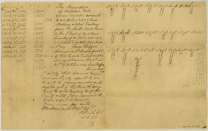
Meanders of Sulphur Fork of Red River, Red River County, Texas
Print $3.00
- Digital $50.00
Meanders of Sulphur Fork of Red River, Red River County, Texas
1841
Size 10.0 x 15.8 inches
Map/Doc 65793
Webb County Rolled Sketch 28

Print $20.00
- Digital $50.00
Webb County Rolled Sketch 28
1932
Size 27.5 x 20.6 inches
Map/Doc 8186
Live Oak County Working Sketch 26

Print $20.00
- Digital $50.00
Live Oak County Working Sketch 26
1980
Size 13.9 x 16.9 inches
Map/Doc 70611
Fisher County Sketch File 8

Print $16.00
- Digital $50.00
Fisher County Sketch File 8
1898
Size 14.7 x 9.1 inches
Map/Doc 22567
Culberson County Rolled Sketch SL

Print $20.00
- Digital $50.00
Culberson County Rolled Sketch SL
1930
Size 19.1 x 24.7 inches
Map/Doc 5683
Crockett County Working Sketch 3

Print $20.00
- Digital $50.00
Crockett County Working Sketch 3
Size 21.5 x 16.5 inches
Map/Doc 68336
You may also like
Presidio County Rolled Sketch 87

Print $20.00
- Digital $50.00
Presidio County Rolled Sketch 87
Size 26.4 x 38.2 inches
Map/Doc 7373
Railroad Track Map, H&TCRRCo., Falls County, Texas

Print $4.00
- Digital $50.00
Railroad Track Map, H&TCRRCo., Falls County, Texas
1918
Size 11.7 x 18.5 inches
Map/Doc 62861
Culberson County Working Sketch 31

Print $20.00
- Digital $50.00
Culberson County Working Sketch 31
1958
Size 30.5 x 30.0 inches
Map/Doc 68484
Sutton County Sketch File 33a-b

Print $7.00
- Digital $50.00
Sutton County Sketch File 33a-b
1934
Size 8.4 x 8.4 inches
Map/Doc 37469

Harris County Working Sketch 37

Print $20.00
- Digital $50.00
Harris County Working Sketch 37
1938
Size 25.4 x 28.0 inches
Map/Doc 65929
Travis County Appraisal District Plat Map 2_0605

Print $20.00
- Digital $50.00
Travis County Appraisal District Plat Map 2_0605
Size 21.4 x 26.4 inches
Map/Doc 94240
Fractional Township No. 8 South Range No. 15 East of the Indian Meridian, Indian Territory

Print $20.00
- Digital $50.00
Fractional Township No. 8 South Range No. 15 East of the Indian Meridian, Indian Territory
1896
Size 19.1 x 24.3 inches
Map/Doc 75227
Tarrant County Working Sketch 25

Print $20.00
- Digital $50.00
Tarrant County Working Sketch 25
2004
Size 27.3 x 38.0 inches
Map/Doc 83585
A2 - Part of the Boundary between the United States and Texas from Sabine River Northward to the 36th mile mound

Print $20.00
- Digital $50.00
A2 - Part of the Boundary between the United States and Texas from Sabine River Northward to the 36th mile mound
Size 28.5 x 22.0 inches
Map/Doc 94003
Angelina County Working Sketch 16

Print $20.00
- Digital $50.00
Angelina County Working Sketch 16
1935
Size 31.0 x 27.0 inches
Map/Doc 67097
