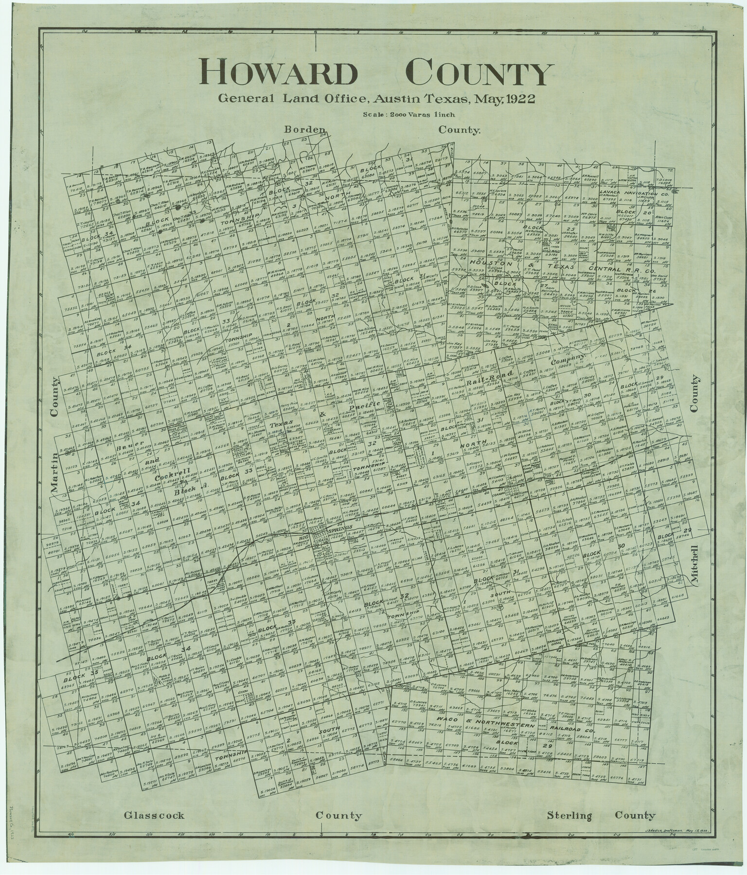
Howard County
-
Map/Doc
66872
-
Collection
General Map Collection
-
Object Dates
1922/5/15 (Creation Date)
-
People and Organizations
Texas General Land Office (Publisher)
John D. Hedick (Compiler)
John D. Hedick (Draftsman)
-
Counties
Howard
-
Subjects
County
-
Height x Width
44.0 x 37.5 inches
111.8 x 95.3 cm
Part of: General Map Collection
Brown County Working Sketch 15

Print $20.00
- Digital $50.00
Brown County Working Sketch 15
1989
Size 23.6 x 16.7 inches
Map/Doc 67780
Flight Mission No. DQO-8K, Frame 139, Galveston County

Print $20.00
- Digital $50.00
Flight Mission No. DQO-8K, Frame 139, Galveston County
1952
Size 18.6 x 22.4 inches
Map/Doc 85201
Hutchinson County Rolled Sketch 12

Print $20.00
- Digital $50.00
Hutchinson County Rolled Sketch 12
Size 26.1 x 41.4 inches
Map/Doc 6282
Carson County Boundary File 9

Print $74.00
- Digital $50.00
Carson County Boundary File 9
Size 9.0 x 8.9 inches
Map/Doc 51175
Zavala County Rolled Sketch 23

Print $20.00
- Digital $50.00
Zavala County Rolled Sketch 23
1943
Size 17.0 x 25.6 inches
Map/Doc 8326
Kimble County Sketch File 41

Print $10.00
- Digital $50.00
Kimble County Sketch File 41
1994
Size 11.2 x 8.7 inches
Map/Doc 29010
Upton County Sketch File 17

Print $6.00
- Digital $50.00
Upton County Sketch File 17
Size 11.0 x 10.9 inches
Map/Doc 38875
Shackelford County Working Sketch 2

Print $20.00
- Digital $50.00
Shackelford County Working Sketch 2
1914
Size 17.2 x 17.3 inches
Map/Doc 63842
Flight Mission No. DCL-6C, Frame 19, Kenedy County

Print $20.00
- Digital $50.00
Flight Mission No. DCL-6C, Frame 19, Kenedy County
1943
Size 18.6 x 22.4 inches
Map/Doc 85876
Smith County Working Sketch 3

Print $20.00
- Digital $50.00
Smith County Working Sketch 3
Size 16.0 x 12.6 inches
Map/Doc 63888
Liberty County Working Sketch 52

Print $20.00
- Digital $50.00
Liberty County Working Sketch 52
1956
Size 32.5 x 24.6 inches
Map/Doc 70512
Flight Mission No. DQO-7K, Frame 82, Galveston County

Print $20.00
- Digital $50.00
Flight Mission No. DQO-7K, Frame 82, Galveston County
1952
Size 18.8 x 22.5 inches
Map/Doc 85109
You may also like

Coryell County Working Sketch 3

Print $20.00
- Digital $50.00
Coryell County Working Sketch 3
1928
Size 23.6 x 22.5 inches
Map/Doc 68210
Hutchinson Co.

Print $20.00
- Digital $50.00
Hutchinson Co.
1891
Size 27.5 x 21.3 inches
Map/Doc 4986
Hidalgo County Working Sketch 2

Print $20.00
- Digital $50.00
Hidalgo County Working Sketch 2
1906
Size 22.0 x 28.0 inches
Map/Doc 66179
Lampasas County Rolled Sketch 4

Print $20.00
- Digital $50.00
Lampasas County Rolled Sketch 4
2001
Size 27.1 x 38.5 inches
Map/Doc 6566
General Highway Map, Gaines County, Texas

Print $20.00
General Highway Map, Gaines County, Texas
1961
Size 24.6 x 18.0 inches
Map/Doc 79475
Anderson County

Print $40.00
- Digital $50.00
Anderson County
1942
Size 53.5 x 47.1 inches
Map/Doc 73066
New and Correct Map of the Great Rock Island Route - Chicago, Rock Island, & Pacific Railway

Print $20.00
- Digital $50.00
New and Correct Map of the Great Rock Island Route - Chicago, Rock Island, & Pacific Railway
1892
Size 20.0 x 42.2 inches
Map/Doc 95865
Wise County Sketch File 45

Print $4.00
- Digital $50.00
Wise County Sketch File 45
Size 8.6 x 14.2 inches
Map/Doc 40605
Cienega Ranch

Print $20.00
- Digital $50.00
Cienega Ranch
1947
Size 17.5 x 17.1 inches
Map/Doc 92287

Jasper County Working Sketch 4

Print $20.00
- Digital $50.00
Jasper County Working Sketch 4
1905
Size 20.3 x 13.5 inches
Map/Doc 66466