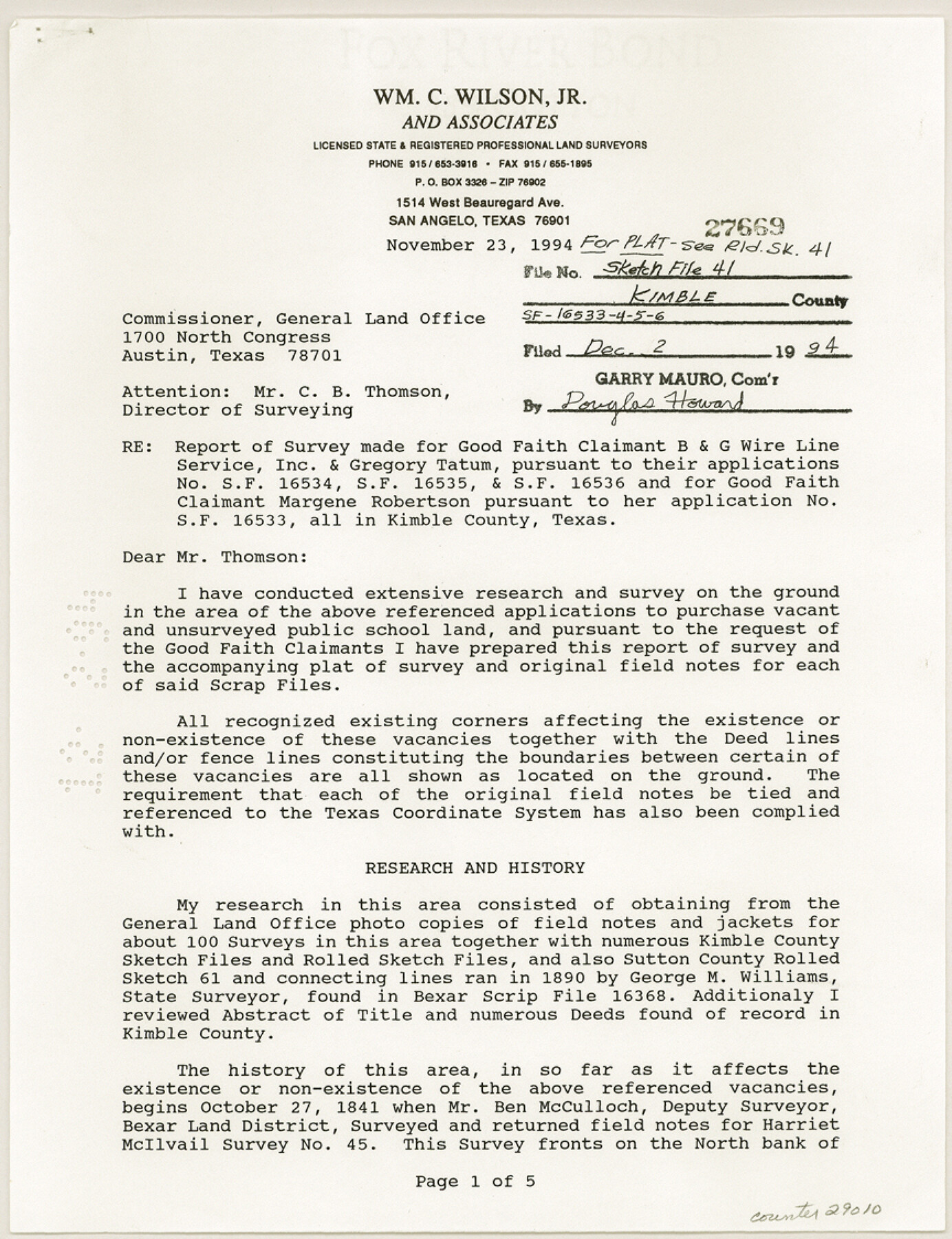
Kimble County Sketch File 41
[Report of survey made for Good Faith Claimant B. & G. Wire Line Service, Inc. and Gregory Tatum pursuant to their applications no. SF-16534, SF-16535 and SF-16536 and for Good Faith Claimant Margene Robertson pursuant to her application no. SF-16533]
-
Map/Doc
29010
-
Collection
General Map Collection
-
Object Dates
11/23/1994 (Creation Date)
12/2/1994 (File Date)
-
People and Organizations
Wm. C. Wilson, Jr. (Surveyor/Engineer)
-
Counties
Kimble
-
Subjects
Surveying Sketch File
-
Height x Width
11.2 x 8.7 inches
28.5 x 22.1 cm
-
Medium
paper, print
-
Comments
See Kimble County Rolled Sketch 41 (9340) for sketch.
-
Features
North Llano River
Bear Creek
Viejo Creek
Related maps
Kimble County Rolled Sketch 41

Print $40.00
- Digital $50.00
Kimble County Rolled Sketch 41
1994
Size 38.0 x 48.9 inches
Map/Doc 9340
Part of: General Map Collection

Flight Mission No. CUG-3P, Frame 39, Kleberg County

Print $20.00
- Digital $50.00
Flight Mission No. CUG-3P, Frame 39, Kleberg County
1956
Size 18.4 x 22.2 inches
Map/Doc 86244
Potter County Working Sketch 13

Print $20.00
- Digital $50.00
Potter County Working Sketch 13
1980
Size 19.5 x 26.9 inches
Map/Doc 71673
Frio County Rolled Sketch HM2

Print $20.00
- Digital $50.00
Frio County Rolled Sketch HM2
1935
Size 41.3 x 30.6 inches
Map/Doc 8899
[Center Line of the Texas and Pacific Railroad Company 16 Mile Reserve]
![3125, [Center Line of the Texas and Pacific Railroad Company 16 Mile Reserve], General Map Collection](https://historictexasmaps.com/wmedia_w700/maps/3125-1.tif.jpg)
Print $40.00
- Digital $50.00
[Center Line of the Texas and Pacific Railroad Company 16 Mile Reserve]
1876
Size 43.1 x 55.6 inches
Map/Doc 3125

[Galveston, Harrisburg & San Antonio Railroad from Cuero to Stockdale]
![64189, [Galveston, Harrisburg & San Antonio Railroad from Cuero to Stockdale], General Map Collection](https://historictexasmaps.com/wmedia_w700/maps/64189.tif.jpg)
Print $20.00
- Digital $50.00
[Galveston, Harrisburg & San Antonio Railroad from Cuero to Stockdale]
1907
Size 13.8 x 34.0 inches
Map/Doc 64189
Map of Wilbarger County Young Land District formerly Fannin Land District

Print $20.00
- Digital $50.00
Map of Wilbarger County Young Land District formerly Fannin Land District
1859
Size 22.7 x 20.6 inches
Map/Doc 4146
Controlled Mosaic by Jack Amman Photogrammetric Engineers, Inc - Sheet 3

Print $20.00
- Digital $50.00
Controlled Mosaic by Jack Amman Photogrammetric Engineers, Inc - Sheet 3
1954
Size 20.0 x 24.0 inches
Map/Doc 83447
Real County Working Sketch 49

Print $20.00
- Digital $50.00
Real County Working Sketch 49
1957
Size 25.9 x 25.7 inches
Map/Doc 71941
Stonewall County Boundary File 4

Print $32.00
- Digital $50.00
Stonewall County Boundary File 4
Size 14.4 x 9.1 inches
Map/Doc 58977
Galveston County Rolled Sketch 14

Print $155.00
- Digital $50.00
Galveston County Rolled Sketch 14
1950
Size 10.1 x 15.3 inches
Map/Doc 44808
You may also like
Hockley County Sketch File 10

Print $6.00
- Digital $50.00
Hockley County Sketch File 10
1921
Size 11.2 x 8.8 inches
Map/Doc 26541
Hamilton County Sketch File 5

Print $4.00
- Digital $50.00
Hamilton County Sketch File 5
Size 10.2 x 8.1 inches
Map/Doc 24908
Reagan County Working Sketch 39

Print $20.00
- Digital $50.00
Reagan County Working Sketch 39
1971
Size 22.5 x 36.1 inches
Map/Doc 71881
Zavala County Sketch File 10

Print $20.00
- Digital $50.00
Zavala County Sketch File 10
Size 17.6 x 25.7 inches
Map/Doc 12728
Smith County Working Sketch 19

Print $20.00
- Digital $50.00
Smith County Working Sketch 19
1997
Size 31.4 x 36.5 inches
Map/Doc 63904
Flight Mission No. DQN-2K, Frame 64, Calhoun County

Print $20.00
- Digital $50.00
Flight Mission No. DQN-2K, Frame 64, Calhoun County
1953
Size 18.6 x 22.3 inches
Map/Doc 84256
Culberson County Working Sketch 23a

Print $20.00
- Digital $50.00
Culberson County Working Sketch 23a
1947
Size 32.1 x 46.4 inches
Map/Doc 68475
Map of the Columbia and Wharton Division of the Galveston & Eagle Pass Airline Railway

Print $20.00
- Digital $50.00
Map of the Columbia and Wharton Division of the Galveston & Eagle Pass Airline Railway
1881
Size 30.3 x 17.3 inches
Map/Doc 64483
Flight Mission No. BRA-6M, Frame 146, Jefferson County

Print $20.00
- Digital $50.00
Flight Mission No. BRA-6M, Frame 146, Jefferson County
1953
Size 18.6 x 22.3 inches
Map/Doc 85447
Fisher County Working Sketch 11

Print $20.00
- Digital $50.00
Fisher County Working Sketch 11
1952
Size 21.2 x 35.1 inches
Map/Doc 69145

