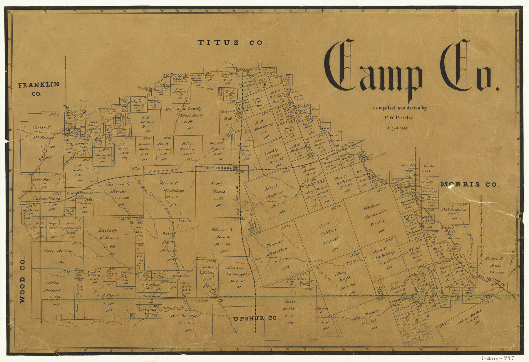
Camp County
-
Map/Doc
3366
-
Collection
General Map Collection
-
Object Dates
8/1897 (Creation Date)
-
People and Organizations
Chas. W. Pressler (Draftsman)
-
Counties
Camp
-
Subjects
County
-
Height x Width
18.0 x 26.3 inches
45.7 x 66.8 cm
-
Features
SLS
Dillard's Creek
Holly Creek
Richland Creek
Caddo Trace
Lilly's Creek
Prairie Creek
Boggy Creek
Bruton's Creek
Cherokee Trace
Jake's Creek
Stubblefield's Creek
Pittsburg
EL&RR
Walnut Creek
Dry Fork [of Big Cypress Creek]
Walker's Creek
Picket's Spring Branch [of Big Cypress Creek]
Big Cypress Creek
Part of: General Map Collection
Flight Mission No. CRK-3P, Frame 127, Refugio County

Print $20.00
- Digital $50.00
Flight Mission No. CRK-3P, Frame 127, Refugio County
1956
Size 18.6 x 22.3 inches
Map/Doc 86915
Harris County Working Sketch 83

Print $20.00
- Digital $50.00
Harris County Working Sketch 83
1970
Size 26.0 x 30.1 inches
Map/Doc 65975
[G.C. and S. F. R.R. Co. Through Bosque County from McLennan Co. and E. to Hill Co. Station M. P. 259 to M. P. 297]
![64564, [G.C. and S. F. R.R. Co. Through Bosque County from McLennan Co. and E. to Hill Co. Station M. P. 259 to M. P. 297], General Map Collection](https://historictexasmaps.com/wmedia_w700/maps/64564-1.tif.jpg)
Print $40.00
- Digital $50.00
[G.C. and S. F. R.R. Co. Through Bosque County from McLennan Co. and E. to Hill Co. Station M. P. 259 to M. P. 297]
1898
Size 22.4 x 101.5 inches
Map/Doc 64564
Aransas County Rolled Sketch 16

Digital $50.00
Aransas County Rolled Sketch 16
Size 44.1 x 92.5 inches
Map/Doc 8412
La Salle County Rolled Sketch 6A

Print $40.00
- Digital $50.00
La Salle County Rolled Sketch 6A
1941
Size 46.0 x 69.8 inches
Map/Doc 10724
Callahan County Working Sketch 10

Print $20.00
- Digital $50.00
Callahan County Working Sketch 10
1967
Size 26.9 x 25.5 inches
Map/Doc 67892
[Sketch for Mineral Application 24072, San Jacinto River]
![65590, [Sketch for Mineral Application 24072, San Jacinto River], General Map Collection](https://historictexasmaps.com/wmedia_w700/maps/65590.tif.jpg)
Print $20.00
- Digital $50.00
[Sketch for Mineral Application 24072, San Jacinto River]
1929
Size 40.8 x 14.7 inches
Map/Doc 65590
Brazos County Working Sketch 1

Print $20.00
- Digital $50.00
Brazos County Working Sketch 1
1911
Size 26.5 x 16.3 inches
Map/Doc 67476
Kimble County Sketch File 37

Print $4.00
- Digital $50.00
Kimble County Sketch File 37
1892
Size 11.2 x 8.9 inches
Map/Doc 28990
Jasper County Sketch File 36

Print $32.00
- Digital $50.00
Jasper County Sketch File 36
1987
Size 11.2 x 8.6 inches
Map/Doc 27872
Martin County Rolled Sketch 11

Print $20.00
- Digital $50.00
Martin County Rolled Sketch 11
Size 19.3 x 25.0 inches
Map/Doc 90051
[Map of Grayson County]
![4551, [Map of Grayson County], General Map Collection](https://historictexasmaps.com/wmedia_w700/maps/4551-1.tif.jpg)
Print $20.00
- Digital $50.00
[Map of Grayson County]
1848
Size 25.6 x 20.0 inches
Map/Doc 4551
You may also like
General Highway Map, Hidalgo County, Texas

Print $20.00
General Highway Map, Hidalgo County, Texas
1940
Size 18.4 x 24.7 inches
Map/Doc 79127
San Antonio Bay and Vicinity in Aransas and Calhoun Counties, showing Subdivsion for Mineral Development

Print $40.00
- Digital $50.00
San Antonio Bay and Vicinity in Aransas and Calhoun Counties, showing Subdivsion for Mineral Development
1948
Size 37.0 x 74.5 inches
Map/Doc 1912
Andrews County Rolled Sketch 24

Print $20.00
- Digital $50.00
Andrews County Rolled Sketch 24
1946
Size 43.0 x 35.8 inches
Map/Doc 8397
Colorado County Working Sketch 27

Print $20.00
- Digital $50.00
Colorado County Working Sketch 27
1979
Size 29.1 x 23.3 inches
Map/Doc 68127
Terrell County Rolled Sketch 40

Print $20.00
- Digital $50.00
Terrell County Rolled Sketch 40
1943
Size 16.7 x 18.1 inches
Map/Doc 7944
Glasscock County Sketch File 2

Print $20.00
- Digital $50.00
Glasscock County Sketch File 2
1931
Size 35.1 x 16.2 inches
Map/Doc 11559
San Saba County Sketch File 2

Print $6.00
- Digital $50.00
San Saba County Sketch File 2
1854
Size 4.8 x 7.4 inches
Map/Doc 36405
Calhoun County

Print $20.00
- Digital $50.00
Calhoun County
1883
Size 22.9 x 19.1 inches
Map/Doc 66741
Howard County Sketch File 11

Print $40.00
- Digital $50.00
Howard County Sketch File 11
1937
Size 17.6 x 10.2 inches
Map/Doc 26865
Denton County Rolled Sketch 3

Print $20.00
- Digital $50.00
Denton County Rolled Sketch 3
1959
Size 39.1 x 23.9 inches
Map/Doc 5700
Record of Spanish Titles, Vol. I

Record of Spanish Titles, Vol. I
1845
Size 19.2 x 13.9 inches
Map/Doc 94526
[Map of Line Dividing Fannin and Nacogdoches Districts]
![1707, [Map of Line Dividing Fannin and Nacogdoches Districts], General Map Collection](https://historictexasmaps.com/wmedia_w700/maps/1707-1.tif.jpg)
Print $20.00
- Digital $50.00
[Map of Line Dividing Fannin and Nacogdoches Districts]
1850
Size 34.2 x 39.0 inches
Map/Doc 1707