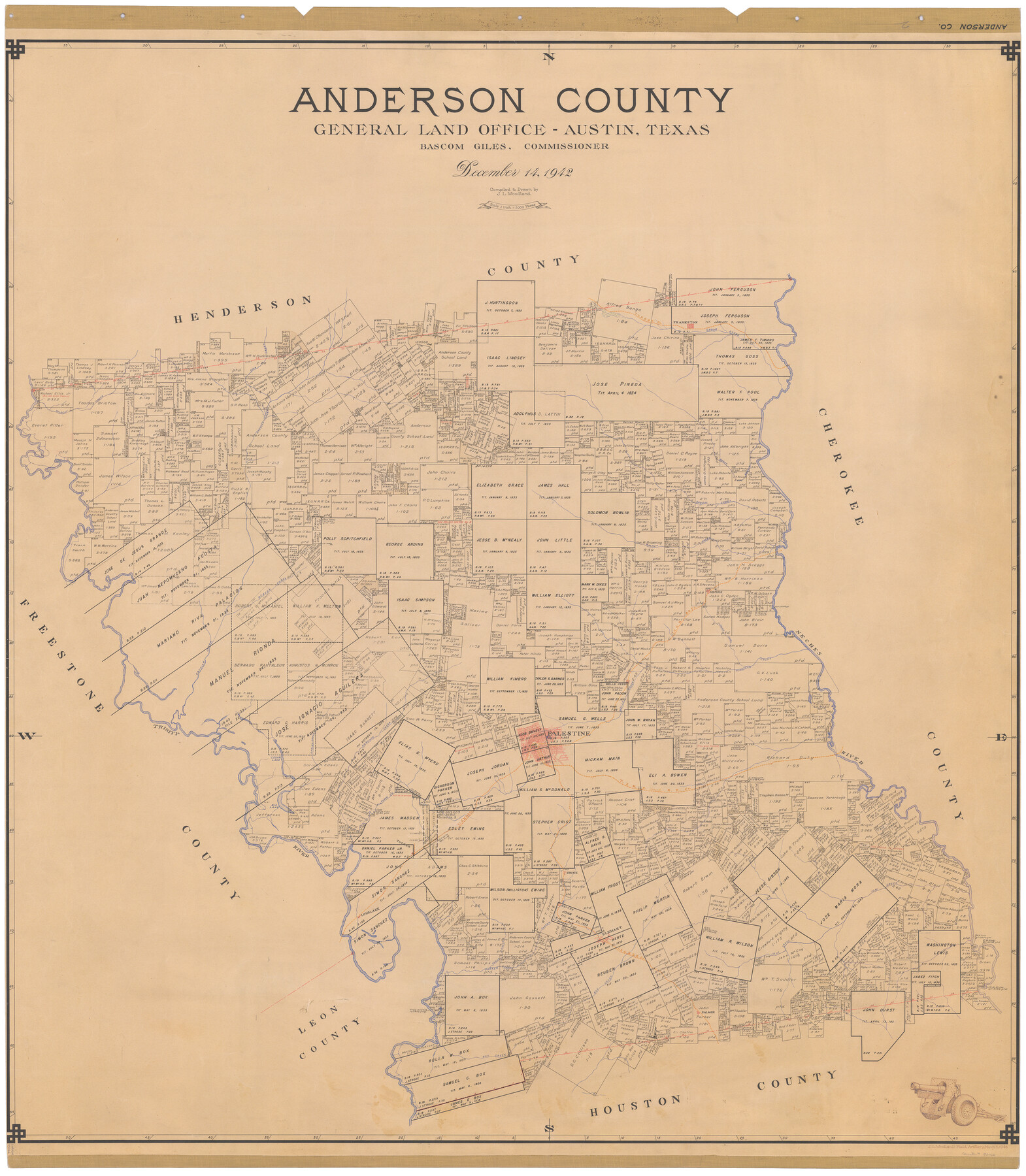
Anderson County
-
Map/Doc
73066
-
Collection
General Map Collection
-
Object Dates
1942/12/14 (Creation Date)
-
People and Organizations
Texas General Land Office (Publisher)
Bascom Giles (GLO Commissioner)
J.L. Woodland (Compiler)
J.L. Woodland (Draftsman)
-
Counties
Anderson
-
Subjects
County
-
Height x Width
53.5 x 47.1 inches
135.9 x 119.6 cm
-
Comments
Note on reverse side: "Compilation completed December 14, 1942. Inking completed April 5, 1943. Tracing completed April 5, 1943. Hung April 6, 1943. Replaced [on sticks] by copy July 29, 1946."
-
Features
Box Creek
Cedar Lake
Big Lake
Town Creek
Ioni Creek
Tucker
Longlake
Cedar Creek
Parker Creek
Spring Creek
Salmon
Coon Creek
Neches
Wells Creek
Trinity Creek
Reiter
Elkhart
Beaver Creek
Catfish Creek
Coon Creek
T&NO
Frankston
Boggy Branch of Neches River
Brushy Creek
Walnut Creek
I&GN
Wildcat Creek
Prairie Creek
Neches River
Hurrican [sic] Creek
Trinity River
Palestine
Wells Creek
Keachie [sic] Creek
Part of: General Map Collection
Travis County Sketch File 7

Print $5.00
- Digital $50.00
Travis County Sketch File 7
1859
Size 9.6 x 17.0 inches
Map/Doc 38286
Gregg County Rolled Sketch MHH1

Print $40.00
- Digital $50.00
Gregg County Rolled Sketch MHH1
1935
Size 167.4 x 23.1 inches
Map/Doc 9064
Presidio County Working Sketch 136

Print $20.00
- Digital $50.00
Presidio County Working Sketch 136
1990
Size 33.7 x 46.8 inches
Map/Doc 71814
Morris County Rolled Sketch 2A

Print $20.00
- Digital $50.00
Morris County Rolled Sketch 2A
Size 22.7 x 17.7 inches
Map/Doc 10227
Brazoria County Rolled Sketch 45

Print $4.00
- Digital $50.00
Brazoria County Rolled Sketch 45
1885
Size 23.0 x 28.5 inches
Map/Doc 5179
Kent County Boundary File 7

Print $6.00
- Digital $50.00
Kent County Boundary File 7
Size 10.8 x 8.7 inches
Map/Doc 55870
Lavaca County Working Sketch 20

Print $20.00
- Digital $50.00
Lavaca County Working Sketch 20
1980
Size 19.2 x 26.0 inches
Map/Doc 70373
Young County Sketch File 22

Print $20.00
- Digital $50.00
Young County Sketch File 22
1957
Size 22.9 x 19.8 inches
Map/Doc 12716
Eastland County Rolled Sketch 19

Print $20.00
- Digital $50.00
Eastland County Rolled Sketch 19
1980
Size 28.9 x 30.9 inches
Map/Doc 8825
Bandera County Working Sketch 18

Print $20.00
- Digital $50.00
Bandera County Working Sketch 18
1946
Size 25.6 x 26.5 inches
Map/Doc 67614
Upton County Working Sketch 10

Print $20.00
- Digital $50.00
Upton County Working Sketch 10
1926
Size 28.1 x 30.6 inches
Map/Doc 69506
Haskell County Rolled Sketch 16

Print $20.00
- Digital $50.00
Haskell County Rolled Sketch 16
1991
Size 45.3 x 39.4 inches
Map/Doc 9148
You may also like
Runnels County Sketch File E

Print $6.00
Runnels County Sketch File E
1895
Size 12.7 x 8.3 inches
Map/Doc 35481
Ulyss Dalmont Ranch situated in Gaines Co., Texas, 21316 Acres

Print $20.00
- Digital $50.00
Ulyss Dalmont Ranch situated in Gaines Co., Texas, 21316 Acres
Size 17.6 x 21.8 inches
Map/Doc 90915
[Sketch showing parts of H. & G. N. RR. Co. Blocks 7 and 8, K. Aycock Block 4, G. H. & H. RR. Co. Block 5 and various surveys west]
![90871, [Sketch showing parts of H. & G. N. RR. Co. Blocks 7 and 8, K. Aycock Block 4, G. H. & H. RR. Co. Block 5 and various surveys west], Twichell Survey Records](https://historictexasmaps.com/wmedia_w700/maps/90871-2.tif.jpg)
Print $20.00
- Digital $50.00
[Sketch showing parts of H. & G. N. RR. Co. Blocks 7 and 8, K. Aycock Block 4, G. H. & H. RR. Co. Block 5 and various surveys west]
1902
Size 25.5 x 17.3 inches
Map/Doc 90871
Hardin County Sketch File 35

Print $24.00
- Digital $50.00
Hardin County Sketch File 35
Size 9.2 x 8.4 inches
Map/Doc 25175
Angelina County Working Sketch 2

Print $20.00
- Digital $50.00
Angelina County Working Sketch 2
1899
Size 18.3 x 23.4 inches
Map/Doc 67082

Galveston County Sketch File 47

Print $14.00
- Digital $50.00
Galveston County Sketch File 47
1976
Size 11.3 x 8.9 inches
Map/Doc 23454
San Augustine County Sketch File 7

Print $4.00
San Augustine County Sketch File 7
1858
Size 7.0 x 8.2 inches
Map/Doc 35646
Flight Mission No. BQR-5K, Frame 71, Brazoria County

Print $20.00
- Digital $50.00
Flight Mission No. BQR-5K, Frame 71, Brazoria County
1952
Size 18.8 x 22.4 inches
Map/Doc 84016
Dallas County Sketch File 15

Print $10.00
- Digital $50.00
Dallas County Sketch File 15
1863
Size 11.5 x 8.5 inches
Map/Doc 20430
Plan De La Nouvelle-Orleans Sur les Manuscrits du Dépôt des Cartes de la Marine

Print $20.00
- Digital $50.00
Plan De La Nouvelle-Orleans Sur les Manuscrits du Dépôt des Cartes de la Marine
1744
Size 9.1 x 13.6 inches
Map/Doc 97354
[Township 5 North, Blocks 33 and 34]
![92568, [Township 5 North, Blocks 33 and 34], Twichell Survey Records](https://historictexasmaps.com/wmedia_w700/maps/92568-1.tif.jpg)
Print $20.00
- Digital $50.00
[Township 5 North, Blocks 33 and 34]
Size 26.3 x 18.7 inches
Map/Doc 92568