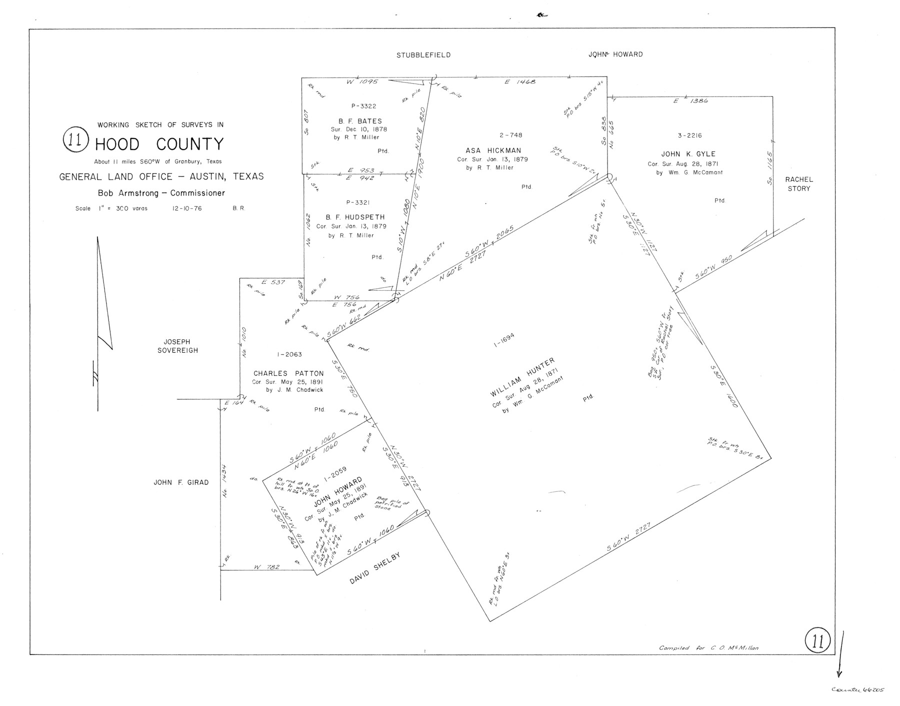
Hood County Working Sketch 11
-
Map/Doc
66205
-
Collection
General Map Collection
-
Object Dates
12/10/1976 (Creation Date)
-
People and Organizations
Beverly Robison (Draftsman)
-
Counties
Hood
-
Subjects
Surveying Working Sketch
-
Height x Width
19.7 x 25.2 inches
50.0 x 64.0 cm
-
Scale
1" = 300 varas
Part of: General Map Collection
Orange County Aerial Photograph Index Sheet 1

Print $20.00
- Digital $50.00
Orange County Aerial Photograph Index Sheet 1
1957
Size 24.1 x 20.4 inches
Map/Doc 83740
Madison County Working Sketch 12

Print $40.00
- Digital $50.00
Madison County Working Sketch 12
1965
Size 41.7 x 48.5 inches
Map/Doc 70774
Bowie County Sketch File 5

Print $4.00
- Digital $50.00
Bowie County Sketch File 5
Size 10.1 x 7.5 inches
Map/Doc 14837
Flight Mission No. BRA-8M, Frame 81, Jefferson County

Print $20.00
- Digital $50.00
Flight Mission No. BRA-8M, Frame 81, Jefferson County
1953
Size 16.0 x 15.8 inches
Map/Doc 85601

Taylor County Sketch File 1a

Print $4.00
- Digital $50.00
Taylor County Sketch File 1a
Size 9.0 x 14.2 inches
Map/Doc 37776
Val Verde County Working Sketch 66

Print $20.00
- Digital $50.00
Val Verde County Working Sketch 66
1964
Size 42.1 x 46.9 inches
Map/Doc 72201
Kerr County Working Sketch Graphic Index

Print $40.00
- Digital $50.00
Kerr County Working Sketch Graphic Index
1923
Size 40.4 x 55.9 inches
Map/Doc 76605
Young County Rolled Sketch 8

Print $20.00
- Digital $50.00
Young County Rolled Sketch 8
Size 40.5 x 25.8 inches
Map/Doc 8296
Concho County Sketch File 5

Print $2.00
- Digital $50.00
Concho County Sketch File 5
1858
Size 8.1 x 7.4 inches
Map/Doc 82974
Map of the Mississippi River from its Source to the Mouth of the Missouri

Print $20.00
- Digital $50.00
Map of the Mississippi River from its Source to the Mouth of the Missouri
1810
Size 10.4 x 31.3 inches
Map/Doc 95153
Pecos County Sketch File 85

Print $19.00
- Digital $50.00
Pecos County Sketch File 85
1948
Size 14.6 x 9.2 inches
Map/Doc 33955
You may also like
Culberson County Working Sketch 2

Print $20.00
- Digital $50.00
Culberson County Working Sketch 2
Size 27.7 x 18.7 inches
Map/Doc 68454
Flight Mission No. DQN-2K, Frame 161, Calhoun County

Print $20.00
- Digital $50.00
Flight Mission No. DQN-2K, Frame 161, Calhoun County
1953
Size 18.5 x 22.3 inches
Map/Doc 84323
Harrison County Working Sketch 33

Print $20.00
- Digital $50.00
Harrison County Working Sketch 33
2015
Size 19.8 x 22.8 inches
Map/Doc 93725
Lebanon Quadrangle

Print $20.00
- Digital $50.00
Lebanon Quadrangle
1999
Size 35.4 x 23.4 inches
Map/Doc 97360
Angelina County Working Sketch 3

Print $20.00
- Digital $50.00
Angelina County Working Sketch 3
1894
Size 17.9 x 16.6 inches
Map/Doc 67083
Edwards County Sketch File 28

Print $5.00
- Digital $50.00
Edwards County Sketch File 28
Size 27.3 x 25.6 inches
Map/Doc 11431
Pecos County Working Sketch 66

Print $20.00
- Digital $50.00
Pecos County Working Sketch 66
1955
Size 25.8 x 21.2 inches
Map/Doc 71538
Flight Mission No. CRE-1R, Frame 196, Jackson County

Print $20.00
- Digital $50.00
Flight Mission No. CRE-1R, Frame 196, Jackson County
1956
Size 18.6 x 22.4 inches
Map/Doc 85350
Plat Showing the Development of Texas Counties from the Original Land Districts

Print $40.00
- Digital $50.00
Plat Showing the Development of Texas Counties from the Original Land Districts
Size 49.6 x 29.5 inches
Map/Doc 73616
Hood County Sketch File 28

Print $84.00
- Digital $50.00
Hood County Sketch File 28
1880
Size 11.6 x 9.0 inches
Map/Doc 26631
Map Showing Block HG and Connecting Surveys

Print $2.00
- Digital $50.00
Map Showing Block HG and Connecting Surveys
1907
Size 9.2 x 13.7 inches
Map/Doc 90681
Carte Generale des Treize Etats-Unis de l'Amerique Septentrionale

Print $20.00
- Digital $50.00
Carte Generale des Treize Etats-Unis de l'Amerique Septentrionale
1783
Size 22.9 x 27.0 inches
Map/Doc 93678