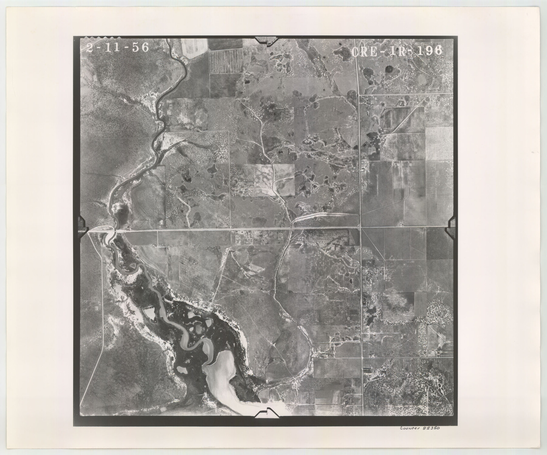
Flight Mission No. CRE-1R, Frame 196, Jackson County
CRE-1R-196
-
Map/Doc
85350
-
Collection
General Map Collection
-
Object Dates
1956/2/11 (Creation Date)
-
People and Organizations
U. S. Department of Agriculture (Publisher)
-
Counties
Jackson
-
Subjects
Aerial Photograph
-
Height x Width
18.6 x 22.4 inches
47.2 x 56.9 cm
-
Comments
Flown by Jack Ammann Photogrammetric Engineers of San Antonio, Texas.
Part of: General Map Collection
Flight Mission No. CUG-3P, Frame 159, Kleberg County

Print $20.00
- Digital $50.00
Flight Mission No. CUG-3P, Frame 159, Kleberg County
1956
Size 18.7 x 22.3 inches
Map/Doc 86279
Red River County Working Sketch 68

Print $20.00
- Digital $50.00
Red River County Working Sketch 68
1975
Size 20.8 x 26.0 inches
Map/Doc 72051
Matagorda Bay Including Lavaca and Tres Palacios Bays

Print $20.00
- Digital $50.00
Matagorda Bay Including Lavaca and Tres Palacios Bays
1975
Size 37.2 x 47.7 inches
Map/Doc 73364
Flight Mission No. BQR-22K, Frame 39, Brazoria County

Print $20.00
- Digital $50.00
Flight Mission No. BQR-22K, Frame 39, Brazoria County
1953
Size 18.8 x 22.4 inches
Map/Doc 84123
[Surveys along the Jefferson and Jasper County Boundary]
![92, [Surveys along the Jefferson and Jasper County Boundary], General Map Collection](https://historictexasmaps.com/wmedia_w700/maps/92.tif.jpg)
Print $3.00
- Digital $50.00
[Surveys along the Jefferson and Jasper County Boundary]
1841
Size 11.8 x 16.3 inches
Map/Doc 92
Coast Chart No. 212 - From Latitude 26° 33' to the Rio Grande, Texas

Print $20.00
- Digital $50.00
Coast Chart No. 212 - From Latitude 26° 33' to the Rio Grande, Texas
1886
Size 30.5 x 24.1 inches
Map/Doc 73504
Hemphill County Rolled Sketch 17

Print $20.00
- Digital $50.00
Hemphill County Rolled Sketch 17
1965
Size 23.5 x 39.9 inches
Map/Doc 6199
Flight Mission No. BRA-16M, Frame 183, Jefferson County

Print $20.00
- Digital $50.00
Flight Mission No. BRA-16M, Frame 183, Jefferson County
1953
Size 18.7 x 22.5 inches
Map/Doc 85781
Hays County Rolled Sketch 31

Print $20.00
- Digital $50.00
Hays County Rolled Sketch 31
2001
Size 24.0 x 34.7 inches
Map/Doc 76421
Austin Map and Street Guide [Verso]
![94163, Austin Map and Street Guide [Verso], General Map Collection](https://historictexasmaps.com/wmedia_w700/maps/94163.tif.jpg)
Austin Map and Street Guide [Verso]
1986
Size 35.5 x 22.8 inches
Map/Doc 94163
Gillespie County

Print $20.00
- Digital $50.00
Gillespie County
1873
Size 16.0 x 22.4 inches
Map/Doc 3580
Runnels County Rolled Sketch 34

Print $20.00
- Digital $50.00
Runnels County Rolled Sketch 34
Size 30.1 x 35.1 inches
Map/Doc 7522
You may also like
Right of Way & Track Map, St. Louis, Brownsville & Mexico Ry. operated by St. Louis, Brownsville & Mexico Ry. Co.

Print $40.00
- Digital $50.00
Right of Way & Track Map, St. Louis, Brownsville & Mexico Ry. operated by St. Louis, Brownsville & Mexico Ry. Co.
1919
Size 25.5 x 57.0 inches
Map/Doc 64626
Gonzales County Boundary File 2

Print $7.00
- Digital $50.00
Gonzales County Boundary File 2
Size 14.4 x 9.0 inches
Map/Doc 53829
Bexar County Working Sketch 15

Print $20.00
- Digital $50.00
Bexar County Working Sketch 15
1972
Size 38.3 x 43.3 inches
Map/Doc 67331
Flight Mission No. CUG-3P, Frame 170, Kleberg County

Print $20.00
- Digital $50.00
Flight Mission No. CUG-3P, Frame 170, Kleberg County
1956
Size 18.6 x 22.2 inches
Map/Doc 86290
Flight Mission No. CUG-3P, Frame 162, Kleberg County

Print $20.00
- Digital $50.00
Flight Mission No. CUG-3P, Frame 162, Kleberg County
1956
Size 18.5 x 22.3 inches
Map/Doc 86282
Tarrant County Rolled Sketch 2

Print $40.00
- Digital $50.00
Tarrant County Rolled Sketch 2
1955
Size 96.5 x 23.5 inches
Map/Doc 9984

Freestone County Working Sketch 25

Print $20.00
- Digital $50.00
Freestone County Working Sketch 25
1984
Size 43.5 x 38.4 inches
Map/Doc 69267

El Paso County Rolled Sketch Z53

Print $40.00
- Digital $50.00
El Paso County Rolled Sketch Z53
1915
Size 36.6 x 51.7 inches
Map/Doc 8869
Sketch Showing Section 3, Block JW, Subdivided to Show Quantity East of Texas Sections

Print $40.00
- Digital $50.00
Sketch Showing Section 3, Block JW, Subdivided to Show Quantity East of Texas Sections
Size 5.8 x 49.9 inches
Map/Doc 91303
Military Map of the Rio Grande Frontier Prepared from Original Surveys, County Maps, Reports of Officers, etc

Print $20.00
Military Map of the Rio Grande Frontier Prepared from Original Surveys, County Maps, Reports of Officers, etc
1883
Size 17.4 x 27.3 inches
Map/Doc 76242