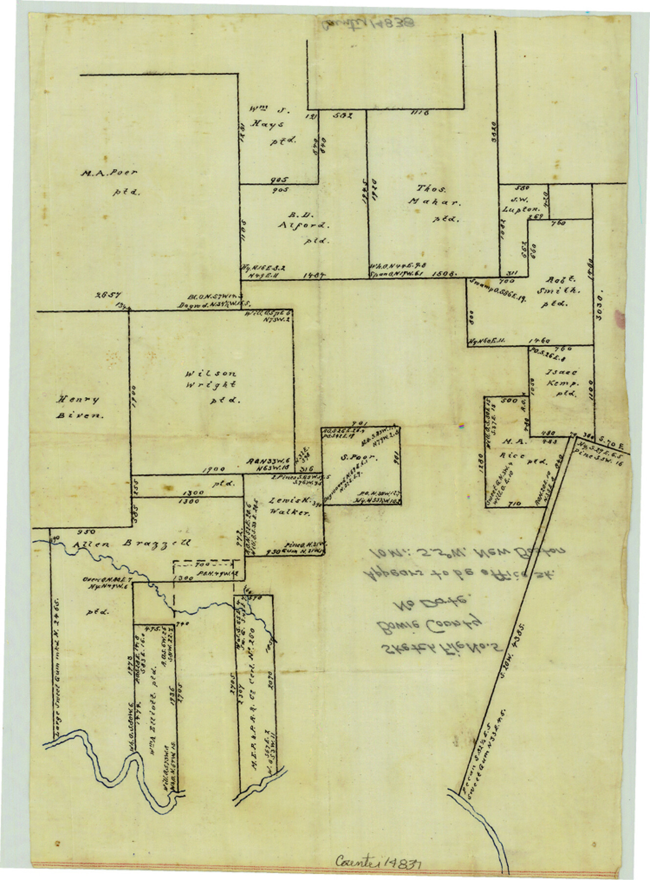
Bowie County Sketch File 5
[Office sketch of surveys south of New Boston]
-
Map/Doc
14837
-
Collection
General Map Collection
-
Counties
Bowie
-
Subjects
Surveying Sketch File
-
Height x Width
10.1 x 7.5 inches
25.7 x 19.1 cm
-
Medium
paper, manuscript
Part of: General Map Collection
San Jacinto County

Print $20.00
- Digital $50.00
San Jacinto County
1949
Size 43.5 x 39.1 inches
Map/Doc 77415
Montague County Working Sketch 41

Print $40.00
- Digital $50.00
Montague County Working Sketch 41
1923
Size 43.3 x 70.1 inches
Map/Doc 65350
Gregg County Working Sketch 10

Print $20.00
- Digital $50.00
Gregg County Working Sketch 10
1939
Size 34.1 x 26.4 inches
Map/Doc 63276
Right of Way & Track Map San Antonio & Aransas Pass Railway Co.

Print $40.00
- Digital $50.00
Right of Way & Track Map San Antonio & Aransas Pass Railway Co.
1919
Size 25.7 x 56.7 inches
Map/Doc 64039
Texas Gulf Coast, from the Sabine River to the Rio Grande as Subdivided for Mineral Development; Matagorda, Calhoun and Aransas Counties

Print $40.00
- Digital $50.00
Texas Gulf Coast, from the Sabine River to the Rio Grande as Subdivided for Mineral Development; Matagorda, Calhoun and Aransas Counties
1976
Size 43.0 x 90.9 inches
Map/Doc 1939
Roberts County Working Sketch 21

Print $20.00
- Digital $50.00
Roberts County Working Sketch 21
1979
Size 35.7 x 45.6 inches
Map/Doc 63547
Trinity River, Levee Improvement Districts, Widths of Floodways/Pilot Grove Creek and East Fork Trinity River

Print $6.00
- Digital $50.00
Trinity River, Levee Improvement Districts, Widths of Floodways/Pilot Grove Creek and East Fork Trinity River
1920
Size 33.0 x 17.1 inches
Map/Doc 65259
Young County Rolled Sketch 6

Print $20.00
- Digital $50.00
Young County Rolled Sketch 6
Size 43.4 x 30.8 inches
Map/Doc 8294
Flight Mission No. CRC-4R, Frame 103, Chambers County

Print $20.00
- Digital $50.00
Flight Mission No. CRC-4R, Frame 103, Chambers County
1956
Size 18.4 x 22.3 inches
Map/Doc 84900
Bexar County Sketch File 1a

Print $24.00
- Digital $50.00
Bexar County Sketch File 1a
1847
Size 12.7 x 8.2 inches
Map/Doc 14468
Chart of the Rio Bravo del Norte traced from a survey made by Henry Austin by Lieut. Bowman, 3d. Infy.

Print $20.00
- Digital $50.00
Chart of the Rio Bravo del Norte traced from a survey made by Henry Austin by Lieut. Bowman, 3d. Infy.
1866
Size 18.3 x 27.8 inches
Map/Doc 72889
Wise County Sketch File 26b

Print $20.00
- Digital $50.00
Wise County Sketch File 26b
1855
Size 13.3 x 19.9 inches
Map/Doc 12700
You may also like
Flight Mission No. BRE-1P, Frame 55, Nueces County

Print $20.00
- Digital $50.00
Flight Mission No. BRE-1P, Frame 55, Nueces County
1956
Size 18.3 x 22.2 inches
Map/Doc 86644
[New York, Texas & Mexican Railway]
![64148, [New York, Texas & Mexican Railway], General Map Collection](https://historictexasmaps.com/wmedia_w700/maps/64148.tif.jpg)
Print $20.00
- Digital $50.00
[New York, Texas & Mexican Railway]
Size 12.1 x 24.1 inches
Map/Doc 64148
Green & Lumsden's Ranch

Print $20.00
- Digital $50.00
Green & Lumsden's Ranch
Size 28.4 x 24.7 inches
Map/Doc 92431

Brewster County Working Sketch 36

Print $20.00
- Digital $50.00
Brewster County Working Sketch 36
1944
Size 22.7 x 42.3 inches
Map/Doc 67570
Fort Bend County Working Sketch 4

Print $20.00
- Digital $50.00
Fort Bend County Working Sketch 4
1909
Size 23.5 x 34.8 inches
Map/Doc 69210
Williamson County Sketch File 16

Print $20.00
- Digital $50.00
Williamson County Sketch File 16
Size 16.8 x 25.5 inches
Map/Doc 12693
Map of the Fort Worth & Denver City Railway, Wichita County, Texas

Print $40.00
- Digital $50.00
Map of the Fort Worth & Denver City Railway, Wichita County, Texas
1885
Size 23.7 x 66.5 inches
Map/Doc 64455
Cass County Working Sketch 55

Print $20.00
- Digital $50.00
Cass County Working Sketch 55
2013
Size 17.3 x 20.6 inches
Map/Doc 93415
Map of Texas containing the Latest Grants & Discoveries

Print $20.00
- Digital $50.00
Map of Texas containing the Latest Grants & Discoveries
1836
Size 13.5 x 9.9 inches
Map/Doc 94039
Hutchinson County Sketch File 15

Print $20.00
- Digital $50.00
Hutchinson County Sketch File 15
Size 20.7 x 26.7 inches
Map/Doc 11813
El Paso County Rolled Sketch 8

Print $40.00
- Digital $50.00
El Paso County Rolled Sketch 8
1882
Size 39.9 x 51.7 inches
Map/Doc 8852