Neches River
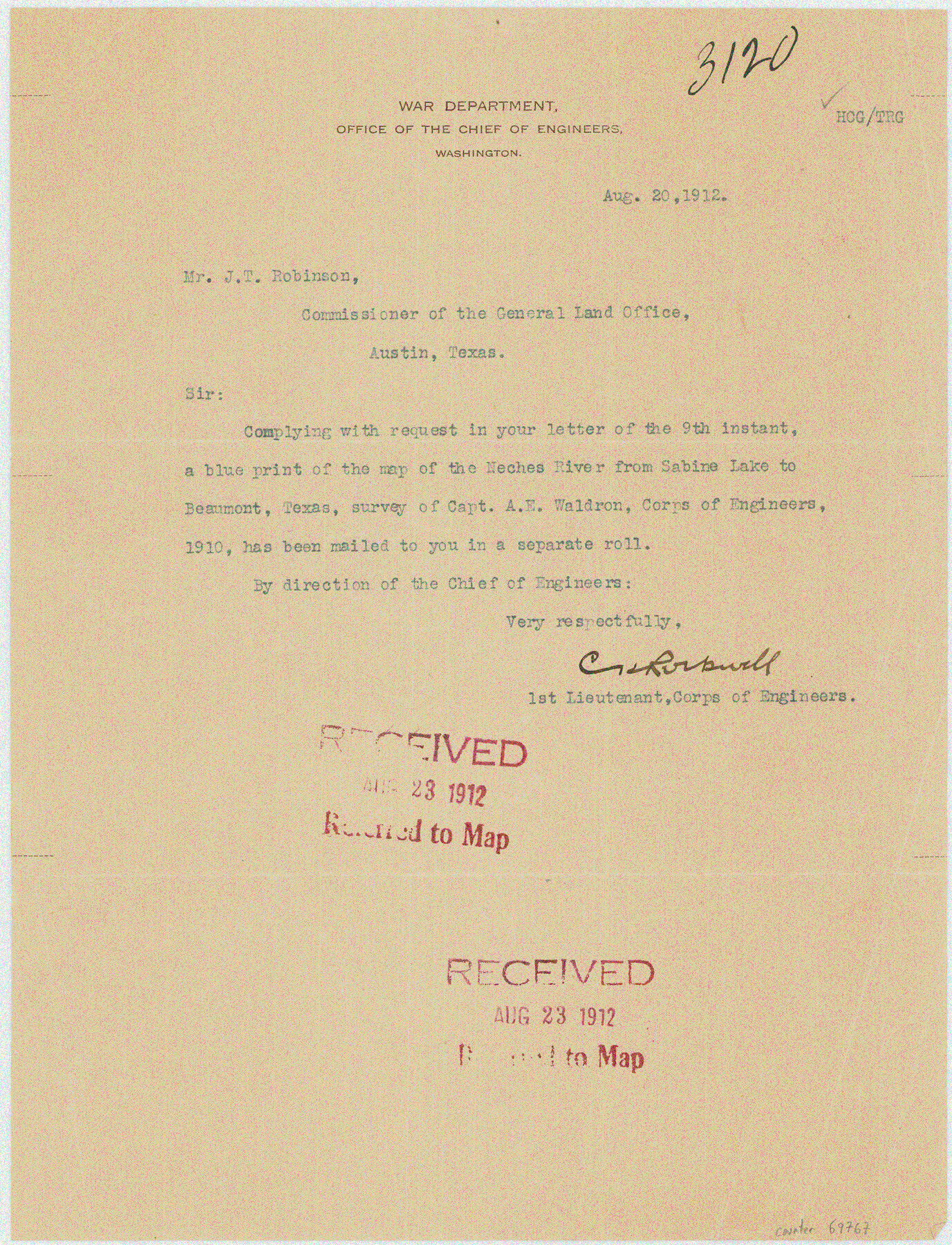
Letter from C. Rockwall, 1st Lieutenant, Corps of Engineers
-
Map/Doc
69767
-
Collection
General Map Collection
-
Object Dates
1912/8/20 (Creation Date)
-
People and Organizations
War Department (Author)
-
Counties
Orange
-
Subjects
River Surveys Topographic
-
Height x Width
10.6 x 8.1 inches
26.9 x 20.6 cm
-
Medium
transmittal letter
-
Comments
To J. T. Robinson, Commissioner of the General Land Office. Received August 23, 1912. See counter no. 2465 for map.
Part of: General Map Collection
[Sketch for Mineral Application 24072, San Jacinto River]
![65605, [Sketch for Mineral Application 24072, San Jacinto River], General Map Collection](https://historictexasmaps.com/wmedia_w700/maps/65605.tif.jpg)
Print $20.00
- Digital $50.00
[Sketch for Mineral Application 24072, San Jacinto River]
1929
Size 23.4 x 17.8 inches
Map/Doc 65605
Shackelford County Sketch File 13

Print $22.00
- Digital $50.00
Shackelford County Sketch File 13
1875
Size 12.8 x 15.8 inches
Map/Doc 36583
Map of Liberty County Texas

Print $20.00
- Digital $50.00
Map of Liberty County Texas
1879
Size 25.4 x 25.3 inches
Map/Doc 42994
Somervell County Working Sketch 5

Print $20.00
- Digital $50.00
Somervell County Working Sketch 5
1975
Size 33.3 x 39.4 inches
Map/Doc 63909
Fractional Township No. 8 South Range No. 18 East of the Indian Meridian, Indian Territory

Print $20.00
- Digital $50.00
Fractional Township No. 8 South Range No. 18 East of the Indian Meridian, Indian Territory
1897
Size 19.2 x 24.3 inches
Map/Doc 75233
Hartley County Sketch File 17

Print $4.00
- Digital $50.00
Hartley County Sketch File 17
1892
Size 11.2 x 8.9 inches
Map/Doc 26115
[Valdez and Martinez grants in the Goliad District]
![54, [Valdez and Martinez grants in the Goliad District], General Map Collection](https://historictexasmaps.com/wmedia_w700/maps/54.tif.jpg)
Print $3.00
- Digital $50.00
[Valdez and Martinez grants in the Goliad District]
1842
Size 10.6 x 9.5 inches
Map/Doc 54
Bee County Working Sketch 16

Print $20.00
- Digital $50.00
Bee County Working Sketch 16
1974
Size 18.0 x 19.6 inches
Map/Doc 67266

Nacogdoches County Sketch File 3

Print $8.00
- Digital $50.00
Nacogdoches County Sketch File 3
Size 6.5 x 8.2 inches
Map/Doc 32237
Flight Mission No. DQN-2K, Frame 75, Calhoun County

Print $20.00
- Digital $50.00
Flight Mission No. DQN-2K, Frame 75, Calhoun County
1953
Size 18.7 x 22.3 inches
Map/Doc 84267
Montgomery County Sketch File 35

Print $8.00
- Digital $50.00
Montgomery County Sketch File 35
1953
Size 14.1 x 8.9 inches
Map/Doc 31908
You may also like
General Highway Map. Detail of Cities and Towns in Erath County, Texas

Print $20.00
General Highway Map. Detail of Cities and Towns in Erath County, Texas
1961
Size 18.2 x 24.7 inches
Map/Doc 79461
Flight Mission No. DQO-8K, Frame 87, Galveston County

Print $20.00
- Digital $50.00
Flight Mission No. DQO-8K, Frame 87, Galveston County
1952
Size 18.6 x 22.4 inches
Map/Doc 85189
Red River County Working Sketch 26

Print $20.00
- Digital $50.00
Red River County Working Sketch 26
1961
Size 30.9 x 31.6 inches
Map/Doc 72009
Red River County Sketch File 27

Print $4.00
- Digital $50.00
Red River County Sketch File 27
1848
Size 12.8 x 8.3 inches
Map/Doc 35163
[Blocks N and B]
![90498, [Blocks N and B], Twichell Survey Records](https://historictexasmaps.com/wmedia_w700/maps/90498-1.tif.jpg)
Print $3.00
- Digital $50.00
[Blocks N and B]
Size 10.0 x 11.4 inches
Map/Doc 90498
Survey Map of Runnels County

Print $20.00
- Digital $50.00
Survey Map of Runnels County
Size 33.6 x 40.3 inches
Map/Doc 92918
Brazoria County Sketch File 13

Print $40.00
- Digital $50.00
Brazoria County Sketch File 13
Size 23.8 x 23.0 inches
Map/Doc 10950
Map of Ferguson State Farm, Madison County, Texas

Print $20.00
- Digital $50.00
Map of Ferguson State Farm, Madison County, Texas
Size 21.6 x 26.1 inches
Map/Doc 62989
Lubbock County Boundary File 5

Print $2.00
- Digital $50.00
Lubbock County Boundary File 5
Size 7.2 x 8.2 inches
Map/Doc 56493
Lamar County Sketch File 16

Print $166.00
- Digital $50.00
Lamar County Sketch File 16
2013
Size 11.0 x 8.5 inches
Map/Doc 93654
Hutchinson County Working Sketch 6

Print $20.00
- Digital $50.00
Hutchinson County Working Sketch 6
1914
Size 20.2 x 29.0 inches
Map/Doc 66364
[Block E, and Portions of Blocks 20 and S]
![91327, [Block E, and Portions of Blocks 20 and S], Twichell Survey Records](https://historictexasmaps.com/wmedia_w700/maps/91327-1.tif.jpg)
Print $20.00
- Digital $50.00
[Block E, and Portions of Blocks 20 and S]
Size 14.9 x 30.2 inches
Map/Doc 91327