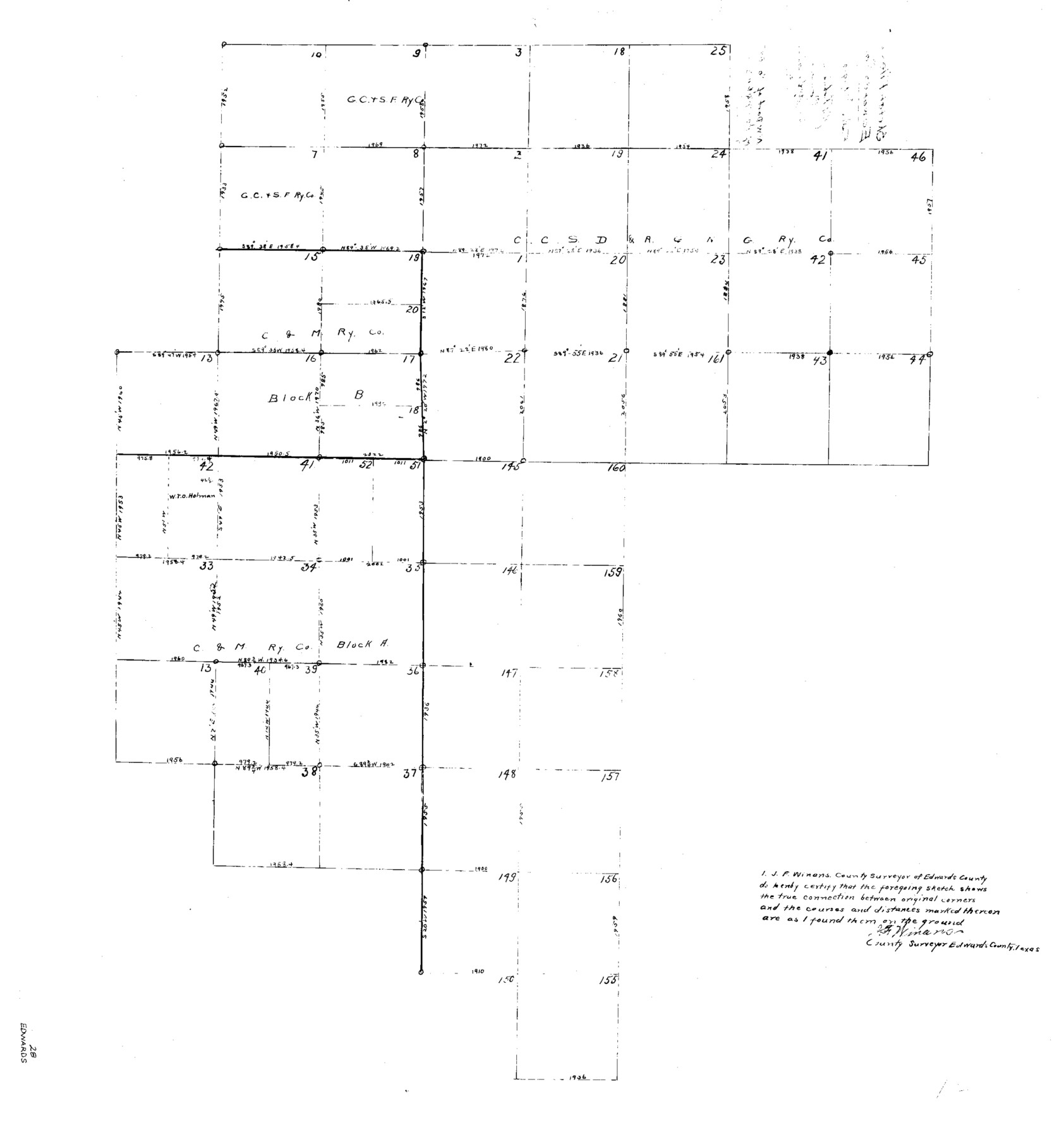
Edwards County Sketch File 28
NW part of Co. - parts of CCSDR&NG Blk. & Blks. A & B
-
Map/Doc
11431
-
Collection
General Map Collection
-
Object Dates
1919/8/9 (File Date)
-
People and Organizations
J.F. Winans (Surveyor/Engineer)
-
Counties
Edwards
-
Subjects
Surveying Sketch File
-
Height x Width
27.3 x 25.6 inches
69.3 x 65.0 cm
-
Medium
paper, photocopy
Part of: General Map Collection
Goliad County Working Sketch 18

Print $20.00
- Digital $50.00
Goliad County Working Sketch 18
1949
Size 31.2 x 39.4 inches
Map/Doc 63208
Bowie County Sketch File 4

Print $4.00
- Digital $50.00
Bowie County Sketch File 4
Size 10.8 x 8.4 inches
Map/Doc 14835
Map of Bexar County

Print $40.00
- Digital $50.00
Map of Bexar County
1887
Size 46.1 x 48.6 inches
Map/Doc 16942

Coke County Rolled Sketch 1

Print $20.00
- Digital $50.00
Coke County Rolled Sketch 1
1943
Size 26.9 x 21.6 inches
Map/Doc 5503


San Augustine and Sabine Counties

Print $20.00
- Digital $50.00
San Augustine and Sabine Counties
1881
Size 23.7 x 26.3 inches
Map/Doc 4012
Hall County Sketch File C2

Print $6.00
- Digital $50.00
Hall County Sketch File C2
1905
Size 14.4 x 9.0 inches
Map/Doc 24789
Bosque County Sketch File 20

Print $4.00
- Digital $50.00
Bosque County Sketch File 20
1863
Size 11.8 x 7.7 inches
Map/Doc 14796
Kinney County Rolled Sketch 1

Print $20.00
- Digital $50.00
Kinney County Rolled Sketch 1
Size 25.1 x 36.1 inches
Map/Doc 6533
Bastrop County Rolled Sketch 4

Print $40.00
- Digital $50.00
Bastrop County Rolled Sketch 4
1999
Size 130.2 x 30.8 inches
Map/Doc 8443
You may also like
Schleicher County Rolled Sketch 12

Print $20.00
- Digital $50.00
Schleicher County Rolled Sketch 12
1952
Size 28.8 x 29.0 inches
Map/Doc 7755
Polk County Working Sketch 29

Print $40.00
- Digital $50.00
Polk County Working Sketch 29
1960
Size 56.0 x 45.0 inches
Map/Doc 71645
Flight Mission No. BQR-20K, Frame 12, Brazoria County

Print $20.00
- Digital $50.00
Flight Mission No. BQR-20K, Frame 12, Brazoria County
1952
Size 18.6 x 22.4 inches
Map/Doc 84114
Brewster County Working Sketch 1

Print $20.00
- Digital $50.00
Brewster County Working Sketch 1
1904
Size 27.4 x 25.8 inches
Map/Doc 67534
Wilbarger County Working Sketch 22

Print $20.00
- Digital $50.00
Wilbarger County Working Sketch 22
1983
Size 39.8 x 33.6 inches
Map/Doc 72560
Gregg County Rolled Sketch JE

Print $94.00
- Digital $50.00
Gregg County Rolled Sketch JE
1931
Size 30.9 x 42.9 inches
Map/Doc 9023
Medina County Working Sketch 4

Print $40.00
- Digital $50.00
Medina County Working Sketch 4
1945
Size 52.6 x 35.5 inches
Map/Doc 70919
Fort Bend County Rolled Sketch 16

Print $20.00
- Digital $50.00
Fort Bend County Rolled Sketch 16
1890
Size 29.3 x 26.5 inches
Map/Doc 5900
Lubbock County Rolled Sketch 3

Print $20.00
- Digital $50.00
Lubbock County Rolled Sketch 3
Size 25.0 x 38.7 inches
Map/Doc 9469
Austin County Sketch File 3

Print $40.00
- Digital $50.00
Austin County Sketch File 3
Size 17.1 x 13.6 inches
Map/Doc 10870
Flight Mission No. DQO-2K, Frame 145, Galveston County

Print $20.00
- Digital $50.00
Flight Mission No. DQO-2K, Frame 145, Galveston County
1952
Size 18.8 x 22.5 inches
Map/Doc 85042
Flight Mission No. DCL-7C, Frame 77, Kenedy County

Print $20.00
- Digital $50.00
Flight Mission No. DCL-7C, Frame 77, Kenedy County
1943
Size 15.3 x 15.2 inches
Map/Doc 86063