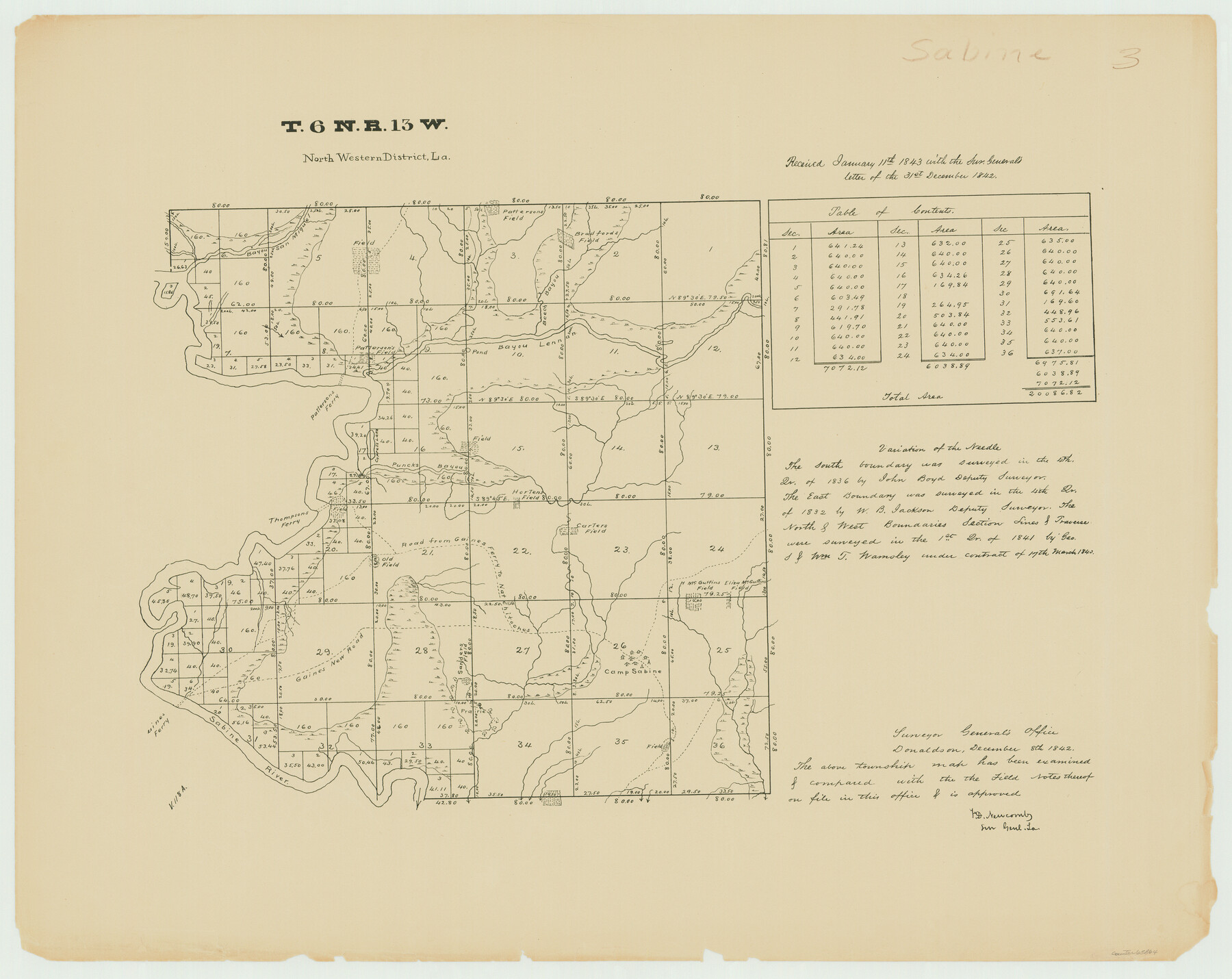
Township 6 North Range 13 West, North Western District, Louisiana
Louisiana Land Surveys Across From Sabine County, Texas 3
-
Map/Doc
65864
-
Collection
General Map Collection
-
Object Dates
1841 (Creation Date)
-
People and Organizations
Surveyor General's Office Louisiana (Publisher)
Geo. S. Walmsley (Surveyor/Engineer)
Wm. T. Walmsley (Surveyor/Engineer)
-
Subjects
Texas Boundaries
-
Height x Width
19.7 x 24.8 inches
50.0 x 63.0 cm
Part of: General Map Collection
Kleberg County Rolled Sketch 10-3

Print $20.00
- Digital $50.00
Kleberg County Rolled Sketch 10-3
1951
Size 37.5 x 32.0 inches
Map/Doc 9388
Flight Mission No. CRE-1R, Frame 131, Jackson County

Print $20.00
- Digital $50.00
Flight Mission No. CRE-1R, Frame 131, Jackson County
1956
Size 16.1 x 15.9 inches
Map/Doc 85339
Colorado County Sketch File 34

Print $86.00
- Digital $50.00
Colorado County Sketch File 34
1996
Size 14.2 x 8.8 inches
Map/Doc 18992
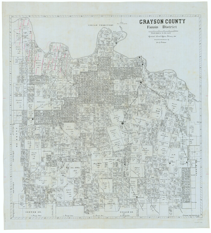
Grayson County Fannin District
Print $20.00
- Digital $50.00
Grayson County Fannin District
1885
Size 43.5 x 39.4 inches
Map/Doc 66840
Ward County Working Sketch 4

Print $20.00
- Digital $50.00
Ward County Working Sketch 4
Size 17.0 x 16.7 inches
Map/Doc 72310
Leon County Rolled Sketch 23

Print $20.00
- Digital $50.00
Leon County Rolled Sketch 23
1981
Size 33.6 x 40.7 inches
Map/Doc 6609
Hall County Sketch File B2

Print $20.00
- Digital $50.00
Hall County Sketch File B2
1904
Size 21.7 x 35.1 inches
Map/Doc 11613
El Paso County Boundary File 19

Print $9.00
- Digital $50.00
El Paso County Boundary File 19
Size 13.6 x 8.7 inches
Map/Doc 53206
Matagorda County

Print $20.00
- Digital $50.00
Matagorda County
1896
Size 32.7 x 30.5 inches
Map/Doc 5082
Morris County Rolled Sketch 2A

Print $20.00
- Digital $50.00
Morris County Rolled Sketch 2A
Size 24.0 x 18.7 inches
Map/Doc 10286
Freestone County Working Sketch 10

Print $20.00
- Digital $50.00
Freestone County Working Sketch 10
1978
Size 40.6 x 33.1 inches
Map/Doc 69252
Brazos River, Brazos River Sheet 1

Print $4.00
- Digital $50.00
Brazos River, Brazos River Sheet 1
1926
Size 21.5 x 25.4 inches
Map/Doc 65293
You may also like
Motley County Sketch File 13 (N)

Print $10.00
- Digital $50.00
Motley County Sketch File 13 (N)
1911
Size 11.1 x 8.6 inches
Map/Doc 32043
General Highway Map, Hale County, Texas

Print $20.00
- Digital $50.00
General Highway Map, Hale County, Texas
1949
Size 18.8 x 25.9 inches
Map/Doc 92661
Kent County Sketch File 13

Print $6.00
- Digital $50.00
Kent County Sketch File 13
1921
Size 11.1 x 8.7 inches
Map/Doc 28839
Current Miscellaneous File 102

Print $611.00
- Digital $50.00
Current Miscellaneous File 102
Size 11.5 x 7.1 inches
Map/Doc 74379
Runnels County Sketch File 4

Print $6.00
Runnels County Sketch File 4
1871
Size 12.9 x 8.1 inches
Map/Doc 35434
'The Cradle of Texas' - San Augustine

Print $20.00
- Digital $50.00
'The Cradle of Texas' - San Augustine
Size 19.3 x 25.3 inches
Map/Doc 94441
Chambers County Sketch File 28

Print $20.00
- Digital $50.00
Chambers County Sketch File 28
1934
Size 26.0 x 19.2 inches
Map/Doc 11067
Houston including Bellaire, Bunker Hill, Galena Park, Hedwig, Hilshire, Hunters Creek, Jacinto City, Jersey Village, Missouri City, Pasadena, Piney Point, South Houston, Spring Valley, West University Place and adjoining communities [Verso]
![94180, Houston including Bellaire, Bunker Hill, Galena Park, Hedwig, Hilshire, Hunters Creek, Jacinto City, Jersey Village, Missouri City, Pasadena, Piney Point, South Houston, Spring Valley, West University Place and adjoining communities [Verso], General Map Collection](https://historictexasmaps.com/wmedia_w700/maps/94180.tif.jpg)
Houston including Bellaire, Bunker Hill, Galena Park, Hedwig, Hilshire, Hunters Creek, Jacinto City, Jersey Village, Missouri City, Pasadena, Piney Point, South Houston, Spring Valley, West University Place and adjoining communities [Verso]
Size 27.1 x 42.4 inches
Map/Doc 94180
McMullen County Working Sketch 21

Print $40.00
- Digital $50.00
McMullen County Working Sketch 21
1947
Size 38.3 x 53.4 inches
Map/Doc 70722
Flight Mission No. BQY-4M, Frame 114, Harris County

Print $20.00
- Digital $50.00
Flight Mission No. BQY-4M, Frame 114, Harris County
1953
Size 18.7 x 22.5 inches
Map/Doc 85281
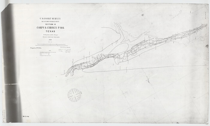
Hydograhic Survey H-994, Corpus Christi Pass
Print $40.00
- Digital $50.00
Hydograhic Survey H-994, Corpus Christi Pass
1869
Size 32.1 x 53.5 inches
Map/Doc 2700
Sketch of Survey 3, Block 1 in Dickens and King Counties

Print $20.00
- Digital $50.00
Sketch of Survey 3, Block 1 in Dickens and King Counties
1914
Size 10.8 x 28.2 inches
Map/Doc 10766