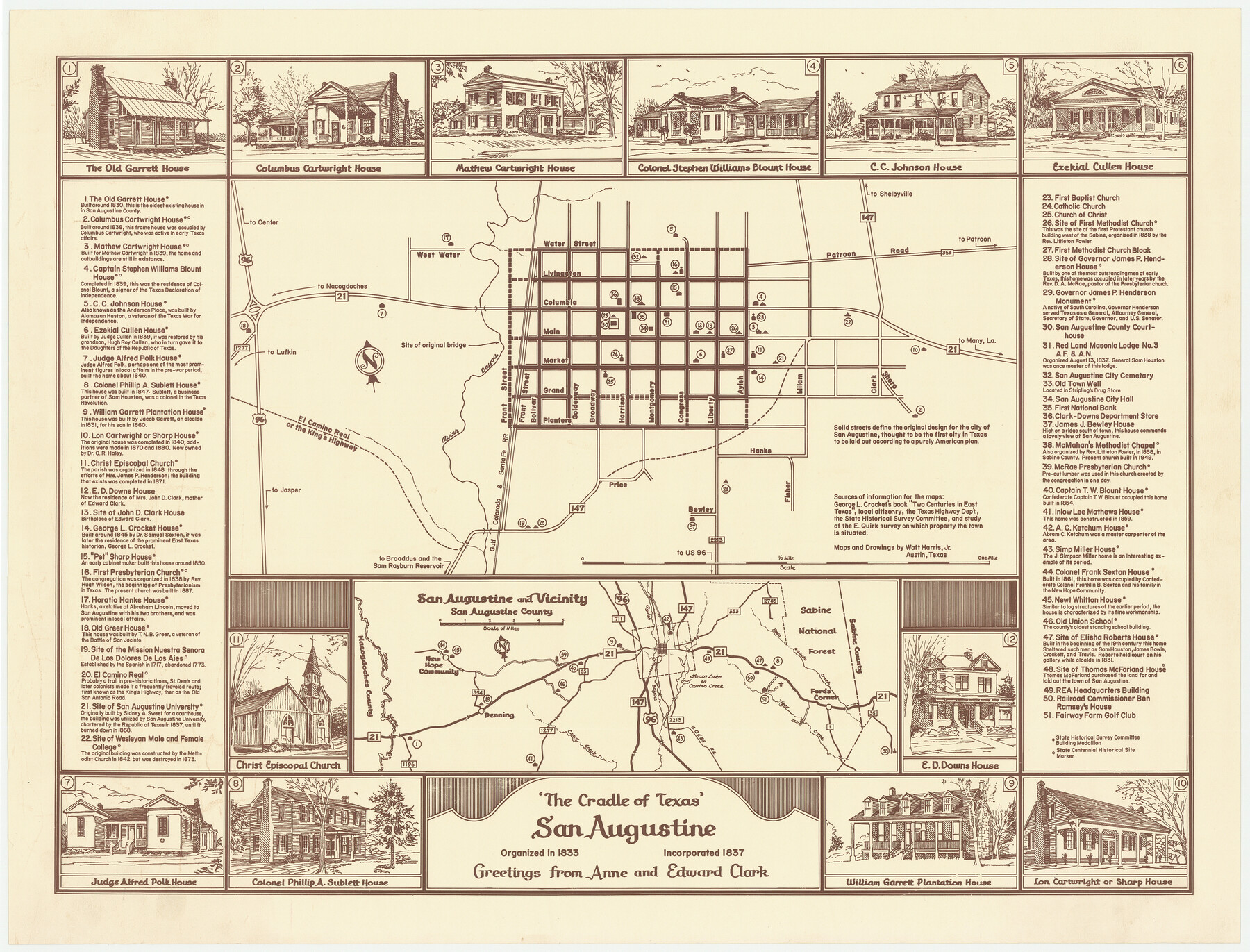
'The Cradle of Texas' - San Augustine
-
Map/Doc
94441
-
Collection
General Map Collection
-
Object Dates
1964
-
People and Organizations
Anne and Edward Clark (Publisher)
Mike Grogan and DeAnna McCabe (Donor)
Walt Harris, Jr. (Draftsman)
Walt Harris, Jr. (Illustrator)
-
Counties
San Augustine
-
Subjects
City
-
Height x Width
19.3 x 25.3 inches
49.0 x 64.3 cm
-
Medium
paper, etching/engraving/lithograph
-
Comments
Edward Clark was legal counsel to LBJ and served as his Ambassador to Australia. This map was produced by Edward and his wife Anne as a gift for LBJ.
Donated to the GLO by Mike Grogan and DeAnna McCabe in October 2017.
Part of: General Map Collection
Uvalde County Working Sketch 24

Print $20.00
- Digital $50.00
Uvalde County Working Sketch 24
1954
Size 21.7 x 23.3 inches
Map/Doc 72094
Hutchinson County Rolled Sketch 36B

Print $20.00
- Digital $50.00
Hutchinson County Rolled Sketch 36B
1888
Size 21.1 x 25.3 inches
Map/Doc 6295
Hardin County Working Sketch 20

Print $20.00
- Digital $50.00
Hardin County Working Sketch 20
1947
Size 38.1 x 32.6 inches
Map/Doc 63418
Comanche County Working Sketch 11

Print $20.00
- Digital $50.00
Comanche County Working Sketch 11
1955
Size 31.7 x 43.3 inches
Map/Doc 68145
Brewster County Sketch File 51

Print $20.00
- Digital $50.00
Brewster County Sketch File 51
1996
Size 13.8 x 8.3 inches
Map/Doc 16352
Hill County Rolled Sketch 1

Print $20.00
- Digital $50.00
Hill County Rolled Sketch 1
1950
Size 13.1 x 41.0 inches
Map/Doc 6214
Aransas County Working Sketch 13

Print $20.00
- Digital $50.00
Aransas County Working Sketch 13
1950
Size 26.0 x 42.2 inches
Map/Doc 67180
Map of Ellis County

Print $40.00
- Digital $50.00
Map of Ellis County
1889
Size 39.2 x 48.1 inches
Map/Doc 4712
Presidio County Working Sketch 81

Print $20.00
- Digital $50.00
Presidio County Working Sketch 81
1967
Size 18.9 x 17.4 inches
Map/Doc 71758
[Located Line of the Panhandle & Gulf Ry. through State Lands]
![64103, [Located Line of the Panhandle & Gulf Ry. through State Lands], General Map Collection](https://historictexasmaps.com/wmedia_w700/maps/64103.tif.jpg)
Print $40.00
- Digital $50.00
[Located Line of the Panhandle & Gulf Ry. through State Lands]
1904
Size 12.4 x 121.6 inches
Map/Doc 64103
Coleman County Working Sketch 6
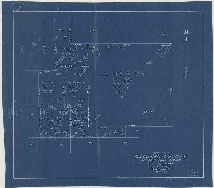
Print $20.00
- Digital $50.00
Coleman County Working Sketch 6
1939
Size 19.1 x 21.8 inches
Map/Doc 68072
Eastham State Farm - Houston, Walker Counties and Ferguson State Farm, Madison County

Print $20.00
- Digital $50.00
Eastham State Farm - Houston, Walker Counties and Ferguson State Farm, Madison County
Size 27.7 x 40.3 inches
Map/Doc 62975
You may also like
[Surveys in Austin's Colony along the San Bernardo River from the mouth of Peach Creek]
![209, [Surveys in Austin's Colony along the San Bernardo River from the mouth of Peach Creek], General Map Collection](https://historictexasmaps.com/wmedia_w700/maps/209.tif.jpg)
Print $20.00
- Digital $50.00
[Surveys in Austin's Colony along the San Bernardo River from the mouth of Peach Creek]
1821
Size 23.4 x 10.6 inches
Map/Doc 209
Houston County

Print $20.00
- Digital $50.00
Houston County
1888
Size 24.5 x 26.1 inches
Map/Doc 3683
Borden County Rolled Sketch 6

Print $20.00
- Digital $50.00
Borden County Rolled Sketch 6
Size 24.6 x 18.6 inches
Map/Doc 5156
Dawson County Sketch File 28

Print $20.00
- Digital $50.00
Dawson County Sketch File 28
1961
Size 46.0 x 15.3 inches
Map/Doc 10362
Reeves County Rolled Sketch 35

Print $20.00
- Digital $50.00
Reeves County Rolled Sketch 35
2013
Size 25.3 x 36.8 inches
Map/Doc 93706
Val Verde County Rolled Sketch 56

Print $20.00
- Digital $50.00
Val Verde County Rolled Sketch 56
1941
Size 39.3 x 22.8 inches
Map/Doc 8125
Mitchell County Sketch File 5

Print $20.00
- Digital $50.00
Mitchell County Sketch File 5
1906
Size 17.5 x 22.2 inches
Map/Doc 12095
Shelby County

Print $20.00
- Digital $50.00
Shelby County
1945
Size 41.6 x 45.9 inches
Map/Doc 73288

Palo Pinto County Sketch File 21

Print $20.00
- Digital $50.00
Palo Pinto County Sketch File 21
1896
Size 18.5 x 17.5 inches
Map/Doc 12133
General Highway Map, Zapata County, Texas

Print $20.00
General Highway Map, Zapata County, Texas
1961
Size 18.0 x 24.7 inches
Map/Doc 79722
Freestone County Sketch File 17

Print $4.00
- Digital $50.00
Freestone County Sketch File 17
1859
Size 6.3 x 8.1 inches
Map/Doc 23074