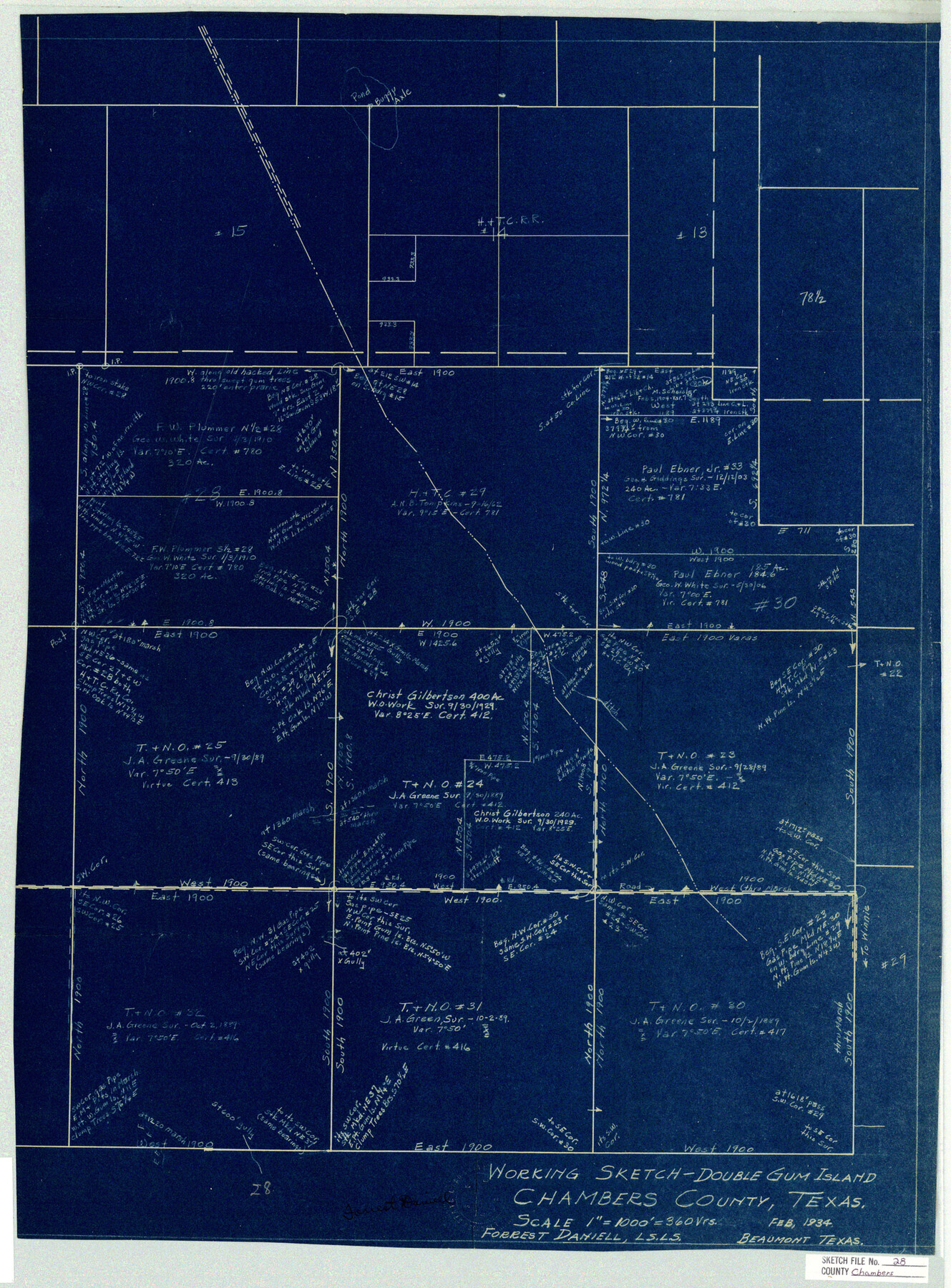
Chambers County Sketch File 28
Working Sketch - Double Gum Island [T. & N. O. R.R. Co. survey no. 24]
-
Map/Doc
11067
-
Collection
General Map Collection
-
Object Dates
1934 (Creation Date)
1934/3/20 (File Date)
-
People and Organizations
Forrest Daniell (Surveyor/Engineer)
-
Counties
Chambers
-
Subjects
Surveying Sketch File
-
Height x Width
26.0 x 19.2 inches
66.0 x 48.8 cm
-
Medium
blueprint/diazo
-
Scale
1" = 360 varas
-
Comments
Also see Chambers County Sketch File 26 (11066) and Chambers County Sketch File 27 (17606).
-
Features
Road to Winnie
Related maps
Chambers County Sketch File 26

Print $20.00
- Digital $50.00
Chambers County Sketch File 26
1934
Size 19.6 x 24.6 inches
Map/Doc 11066
Chambers County Sketch File 27

Print $12.00
- Digital $50.00
Chambers County Sketch File 27
1934
Size 11.3 x 8.8 inches
Map/Doc 17606
Part of: General Map Collection
Briscoe County Sketch File C

Print $40.00
- Digital $50.00
Briscoe County Sketch File C
1900
Size 20.4 x 35.6 inches
Map/Doc 11000
Presidio County Rolled Sketch 86

Print $20.00
- Digital $50.00
Presidio County Rolled Sketch 86
1945
Size 34.1 x 27.8 inches
Map/Doc 7372
DeWitt County

Print $40.00
- Digital $50.00
DeWitt County
1987
Size 42.1 x 50.6 inches
Map/Doc 95481
Coleman County Sketch File 3

Print $4.00
- Digital $50.00
Coleman County Sketch File 3
1857
Size 9.5 x 8.1 inches
Map/Doc 18670
Menard County Boundary File 2b

Print $6.00
- Digital $50.00
Menard County Boundary File 2b
Size 13.3 x 8.2 inches
Map/Doc 57069
Runnels County Rolled Sketch B

Print $20.00
- Digital $50.00
Runnels County Rolled Sketch B
1891
Size 17.4 x 19.3 inches
Map/Doc 7540
Current Miscellaneous File 23

Print $4.00
- Digital $50.00
Current Miscellaneous File 23
1953
Size 14.1 x 5.5 inches
Map/Doc 73881
Flight Mission No. DQN-3K, Frame 70, Calhoun County

Print $20.00
- Digital $50.00
Flight Mission No. DQN-3K, Frame 70, Calhoun County
1953
Size 18.6 x 22.5 inches
Map/Doc 84361
[Surveys possibly in Austin County]
![78356, [Surveys possibly in Austin County], General Map Collection](https://historictexasmaps.com/wmedia_w700/maps/78356.tif.jpg)
Print $3.00
- Digital $50.00
[Surveys possibly in Austin County]
Size 17.0 x 9.6 inches
Map/Doc 78356
Hockley County

Print $20.00
- Digital $50.00
Hockley County
1900
Size 27.0 x 20.7 inches
Map/Doc 6215
Madison County Working Sketch 5

Print $20.00
- Digital $50.00
Madison County Working Sketch 5
1981
Size 24.0 x 24.1 inches
Map/Doc 70767
Galveston County Working Sketch 10

Print $20.00
- Digital $50.00
Galveston County Working Sketch 10
Size 27.0 x 8.9 inches
Map/Doc 62190
You may also like
Flight Mission No. BRA-16M, Frame 128, Jefferson County

Print $20.00
- Digital $50.00
Flight Mission No. BRA-16M, Frame 128, Jefferson County
1953
Size 18.6 x 22.7 inches
Map/Doc 85738
San Saba County Working Sketch 1

Print $20.00
- Digital $50.00
San Saba County Working Sketch 1
1919
Size 15.3 x 15.3 inches
Map/Doc 63789
Flight Mission No. CRC-4R, Frame 150, Chambers County

Print $20.00
- Digital $50.00
Flight Mission No. CRC-4R, Frame 150, Chambers County
1956
Size 18.6 x 22.4 inches
Map/Doc 84913
Armstrong County Working Sketch 4

Print $20.00
- Digital $50.00
Armstrong County Working Sketch 4
1918
Size 23.9 x 32.0 inches
Map/Doc 67235
Crockett County Rolled Sketch 84

Print $20.00
- Digital $50.00
Crockett County Rolled Sketch 84
1961
Size 31.9 x 25.2 inches
Map/Doc 5624
Llano County Sketch File 9

Print $42.00
- Digital $50.00
Llano County Sketch File 9
Size 8.6 x 13.1 inches
Map/Doc 30369
Plat showing survey of tracts in the C. A. West survey A-337 and the Wm. Standiferd survey A-301 in Bastrop County as surveyed for the Veteran's Land Board

Print $20.00
- Digital $50.00
Plat showing survey of tracts in the C. A. West survey A-337 and the Wm. Standiferd survey A-301 in Bastrop County as surveyed for the Veteran's Land Board
1992
Size 34.9 x 46.8 inches
Map/Doc 61151
Wise County Working Sketch 3

Print $20.00
- Digital $50.00
Wise County Working Sketch 3
1946
Size 28.4 x 36.9 inches
Map/Doc 72617
[Sketch of J.D. Brown survey and vicinity]
![89965, [Sketch of J.D. Brown survey and vicinity], Twichell Survey Records](https://historictexasmaps.com/wmedia_w700/maps/89965-1.tif.jpg)
Print $40.00
- Digital $50.00
[Sketch of J.D. Brown survey and vicinity]
Size 43.5 x 63.0 inches
Map/Doc 89965
Upton County Sketch File 2

Print $40.00
- Digital $50.00
Upton County Sketch File 2
Size 38.5 x 55.4 inches
Map/Doc 10413
Schleicher County Working Sketch 5

Print $20.00
- Digital $50.00
Schleicher County Working Sketch 5
1917
Size 23.0 x 17.6 inches
Map/Doc 63807
Houston County Sketch File 42

Print $6.00
- Digital $50.00
Houston County Sketch File 42
1846
Size 11.5 x 9.5 inches
Map/Doc 26830