Kleberg County Rolled Sketch 10-3
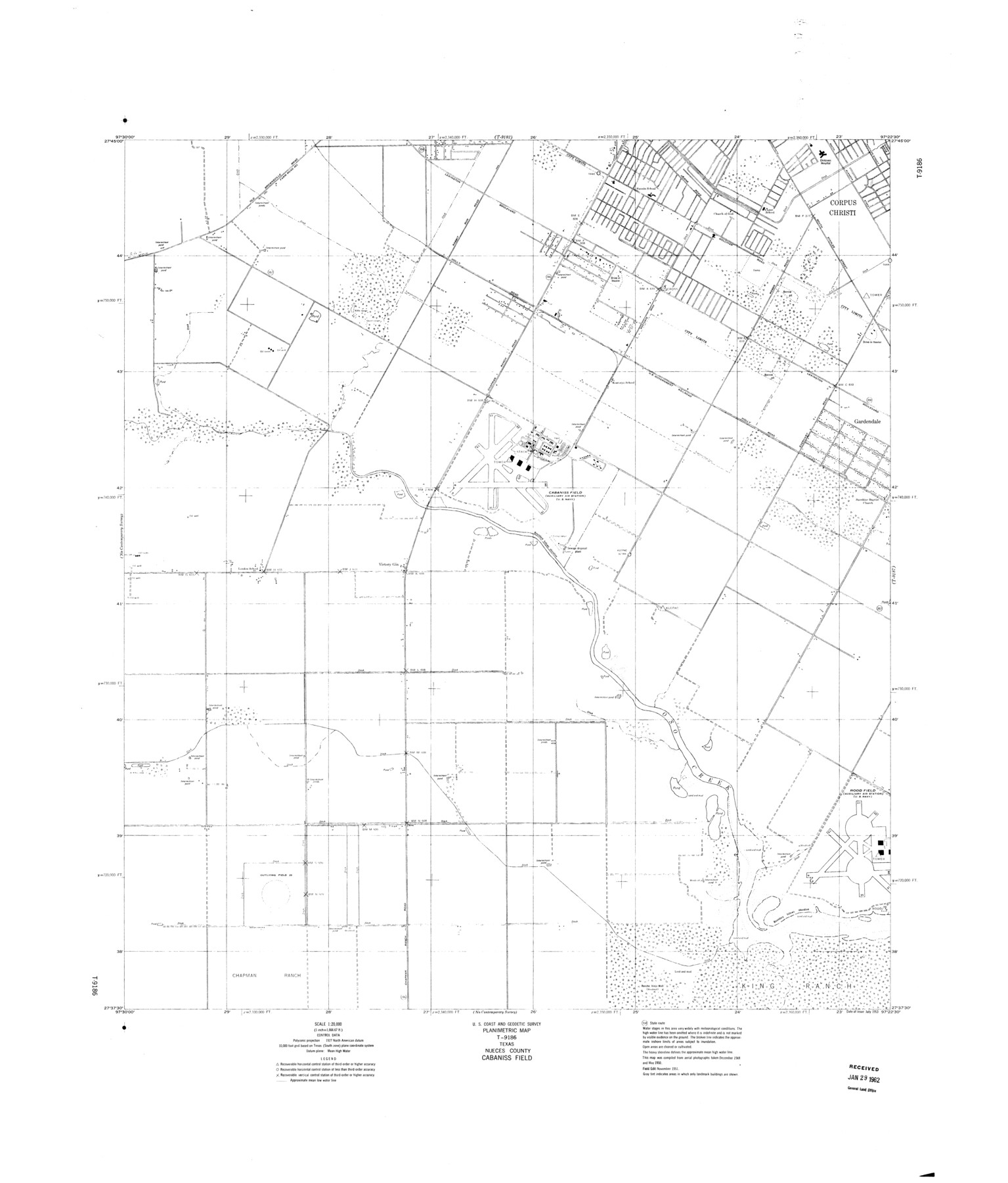
Planimetric Map T-9186, Texas, Nueces County, Cabaniss Field
-
Map/Doc
9388
-
Collection
General Map Collection
-
Object Dates
1951 (Creation Date)
1962/1/29 (File Date)
-
People and Organizations
U.S. Coast and Geodetic Survey (Publisher)
-
Counties
Nueces
-
Subjects
Surveying Rolled Sketch
-
Height x Width
37.5 x 32.0 inches
95.3 x 81.3 cm
Part of: General Map Collection
Upshur County

Print $20.00
- Digital $50.00
Upshur County
1945
Size 40.3 x 36.2 inches
Map/Doc 63085
Frio County Rolled Sketch 12

Print $20.00
- Digital $50.00
Frio County Rolled Sketch 12
1948
Size 36.5 x 45.5 inches
Map/Doc 8904
Northwest Section of Ramsey State Farm

Print $20.00
- Digital $50.00
Northwest Section of Ramsey State Farm
Size 12.6 x 17.2 inches
Map/Doc 94281
San Luis Pass to East Matagorda Bay

Print $40.00
- Digital $50.00
San Luis Pass to East Matagorda Bay
1982
Size 35.6 x 49.3 inches
Map/Doc 69970
Map of Travis County

Print $20.00
- Digital $50.00
Map of Travis County
1861
Size 24.0 x 28.6 inches
Map/Doc 4088
Garza County Rolled Sketch 5A

Print $40.00
- Digital $50.00
Garza County Rolled Sketch 5A
Size 36.4 x 53.8 inches
Map/Doc 3830
Flight Mission No. DQO-1K, Frame 153, Galveston County

Print $20.00
- Digital $50.00
Flight Mission No. DQO-1K, Frame 153, Galveston County
1952
Size 18.8 x 22.5 inches
Map/Doc 85006
Baylor County Sketch File 9

Print $50.00
- Digital $50.00
Baylor County Sketch File 9
1890
Size 13.4 x 9.0 inches
Map/Doc 14139
Wheeler County Sketch File 11

Print $47.00
- Digital $50.00
Wheeler County Sketch File 11
1992
Size 11.5 x 9.0 inches
Map/Doc 40014
Flight Mission No. DIX-3P, Frame 168, Aransas County

Print $20.00
- Digital $50.00
Flight Mission No. DIX-3P, Frame 168, Aransas County
1956
Size 17.7 x 18.3 inches
Map/Doc 83774
Chambers County Sketch File 49

Print $26.00
- Digital $50.00
Chambers County Sketch File 49
Size 14.3 x 8.9 inches
Map/Doc 18045
Cass County Sketch File 5 1/2

Print $4.00
- Digital $50.00
Cass County Sketch File 5 1/2
1851
Size 6.1 x 8.5 inches
Map/Doc 17404
You may also like
Northwest Part of Webb County

Print $40.00
- Digital $50.00
Northwest Part of Webb County
1984
Size 42.0 x 50.2 inches
Map/Doc 77454
Flight Mission No. CRC-4R, Frame 64, Chambers County

Print $20.00
- Digital $50.00
Flight Mission No. CRC-4R, Frame 64, Chambers County
1956
Size 18.7 x 22.3 inches
Map/Doc 84868
Donley County Sketch File 19

Print $20.00
- Digital $50.00
Donley County Sketch File 19
Size 20.4 x 8.4 inches
Map/Doc 11366
Amistad International Reservoir on Rio Grande 72

Print $20.00
- Digital $50.00
Amistad International Reservoir on Rio Grande 72
1949
Size 28.4 x 39.6 inches
Map/Doc 73360
Milam County Sketch File 4

Print $4.00
- Digital $50.00
Milam County Sketch File 4
Size 7.6 x 8.2 inches
Map/Doc 31630

Real County Working Sketch Graphic Index, Sheet 1 (Sketches 1 to 42)

Print $20.00
- Digital $50.00
Real County Working Sketch Graphic Index, Sheet 1 (Sketches 1 to 42)
1972
Size 42.9 x 31.0 inches
Map/Doc 76678
Intracoastal Waterway in Texas - Corpus Christi to Point Isabel including Arroyo Colorado to Mo. Pac. R.R. Bridge Near Harlingen

Print $20.00
- Digital $50.00
Intracoastal Waterway in Texas - Corpus Christi to Point Isabel including Arroyo Colorado to Mo. Pac. R.R. Bridge Near Harlingen
1933
Size 27.9 x 40.7 inches
Map/Doc 61863
Mitchell County Sketch File 16b

Print $20.00
- Digital $50.00
Mitchell County Sketch File 16b
Size 28.7 x 36.8 inches
Map/Doc 10545
Capitol Syndicate Subdivision of Capitol Land Reservation Leagues

Print $20.00
- Digital $50.00
Capitol Syndicate Subdivision of Capitol Land Reservation Leagues
1908
Size 25.6 x 31.5 inches
Map/Doc 92584
Shackelford County Sketch File 11

Print $20.00
- Digital $50.00
Shackelford County Sketch File 11
1914
Size 16.8 x 17.0 inches
Map/Doc 12317
Crockett County Working Sketch 65

Print $20.00
- Digital $50.00
Crockett County Working Sketch 65
1957
Size 32.3 x 38.0 inches
Map/Doc 68398