Leon County Rolled Sketch 23
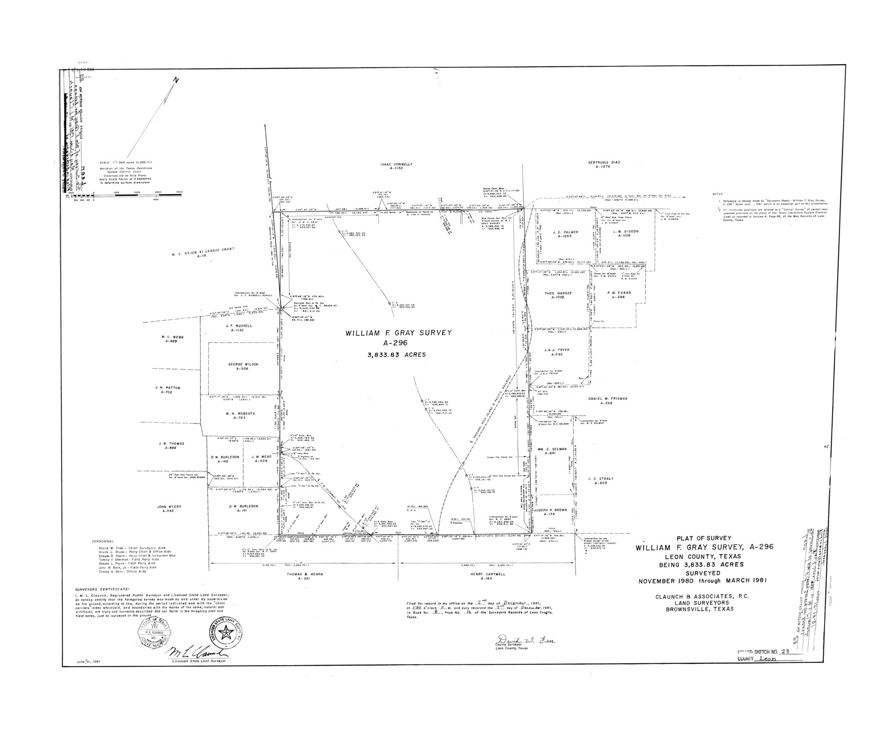
Plat of survey, William F. Gray survey, A-296, Leon County, Texas being 3,833.83 acres
-
Map/Doc
6609
-
Collection
General Map Collection
-
Object Dates
1981/6/30 (Creation Date)
1981/12/19 (File Date)
-
People and Organizations
David W. Free (Chainman/Field Personnel)
M.L. Claunch (Surveyor/Engineer)
Bruce L. Bryan (Chainman/Field Personnel)
Claude D. Payne (Chainman/Field Personnel)
Tommy P. Sherman (Chainman/Field Personnel)
Steven L. Payne (Chainman/Field Personnel)
John W. Bain, Jr. (Chainman/Field Personnel)
Tammy A. Bain (Chainman/Field Personnel)
-
Counties
Leon
-
Subjects
Surveying Rolled Sketch
-
Height x Width
33.6 x 40.7 inches
85.3 x 103.4 cm
-
Scale
1" = 360 varas
Part of: General Map Collection
Young County Rolled Sketch 2

Print $20.00
- Digital $50.00
Young County Rolled Sketch 2
Size 26.2 x 25.0 inches
Map/Doc 8292
Jack County Sketch File 34

Print $20.00
- Digital $50.00
Jack County Sketch File 34
1951
Size 21.2 x 29.3 inches
Map/Doc 11832
Dawson County Sketch File 8

Print $12.00
- Digital $50.00
Dawson County Sketch File 8
1924
Size 11.3 x 9.0 inches
Map/Doc 20536
Comanche County Working Sketch 7

Print $20.00
- Digital $50.00
Comanche County Working Sketch 7
1950
Size 27.3 x 30.6 inches
Map/Doc 68141
Map of Panola County

Print $20.00
- Digital $50.00
Map of Panola County
1882
Size 20.9 x 22.0 inches
Map/Doc 4504
Jackson County Rolled Sketch 2

Print $20.00
- Digital $50.00
Jackson County Rolled Sketch 2
Size 14.1 x 17.9 inches
Map/Doc 6335
Melish's Map Tracing, Surveys on the Red River [See Texas-US Boundary Line File 2]

Digital $50.00
Melish's Map Tracing, Surveys on the Red River [See Texas-US Boundary Line File 2]
Map/Doc 2072
DeWitt County Working Sketch 15

Print $20.00
- Digital $50.00
DeWitt County Working Sketch 15
1991
Size 30.0 x 42.1 inches
Map/Doc 68605
Arlington Street Map & Guide

Digital $50.00
Arlington Street Map & Guide
Size 35.4 x 23.0 inches
Map/Doc 94437
Ellis County Sketch File 7

Print $40.00
- Digital $50.00
Ellis County Sketch File 7
1859
Size 12.2 x 15.6 inches
Map/Doc 21839
Matagorda County Working Sketch 6

Print $20.00
- Digital $50.00
Matagorda County Working Sketch 6
1950
Size 24.2 x 41.5 inches
Map/Doc 70864
Matagorda County Working Sketch 2

Print $20.00
- Digital $50.00
Matagorda County Working Sketch 2
Size 32.6 x 37.0 inches
Map/Doc 70860
You may also like
La Salle County Sketch File 4

Print $22.00
- Digital $50.00
La Salle County Sketch File 4
Size 12.7 x 16.2 inches
Map/Doc 29450
Glasscock County

Print $20.00
- Digital $50.00
Glasscock County
1899
Size 44.2 x 35.5 inches
Map/Doc 4957
Crosby County Rolled Sketch V

Print $20.00
- Digital $50.00
Crosby County Rolled Sketch V
Size 45.4 x 41.8 inches
Map/Doc 8739
Crockett County Working Sketch 3

Print $20.00
- Digital $50.00
Crockett County Working Sketch 3
Size 21.5 x 16.5 inches
Map/Doc 68336
El Paso County Boundary File 4a

Print $44.00
- Digital $50.00
El Paso County Boundary File 4a
Size 14.1 x 8.6 inches
Map/Doc 53044
Upton County Working Sketch 2

Print $20.00
- Digital $50.00
Upton County Working Sketch 2
1906
Size 31.3 x 22.0 inches
Map/Doc 69498
Flight Mission No. DCL-7C, Frame 124, Kenedy County

Print $20.00
- Digital $50.00
Flight Mission No. DCL-7C, Frame 124, Kenedy County
1943
Size 18.6 x 22.2 inches
Map/Doc 86089
Eastland County Sketch File 9

Print $4.00
- Digital $50.00
Eastland County Sketch File 9
Size 10.5 x 8.2 inches
Map/Doc 21580
United States - Gulf Coast Texas - Southern part of Laguna Madre

Print $20.00
- Digital $50.00
United States - Gulf Coast Texas - Southern part of Laguna Madre
1941
Size 26.4 x 18.2 inches
Map/Doc 72945
County School Lands

Print $3.00
- Digital $50.00
County School Lands
1913
Size 10.4 x 14.2 inches
Map/Doc 90450
Flight Mission No. DQN-1K, Frame 111, Calhoun County

Print $20.00
- Digital $50.00
Flight Mission No. DQN-1K, Frame 111, Calhoun County
1953
Size 18.5 x 22.2 inches
Map/Doc 84178
Chart of the Antarctic Continent shewing the icy barrier attached to it discovered by the U.S. Ex. Ex.

Print $20.00
- Digital $50.00
Chart of the Antarctic Continent shewing the icy barrier attached to it discovered by the U.S. Ex. Ex.
1840
Size 26.5 x 37.2 inches
Map/Doc 94058