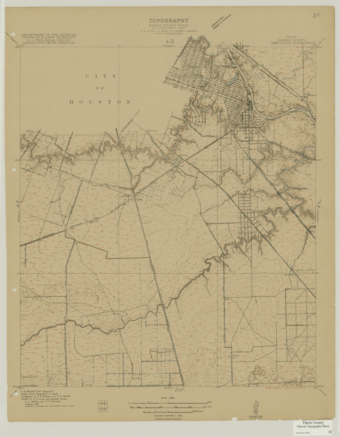
Harris County Historic Topographic 30
Park Place Quadrangle
-
Map/Doc
65841
-
Collection
General Map Collection
-
Object Dates
1915 (Creation Date)
-
People and Organizations
U. S. Geological Survey (Publisher)
-
Counties
Harris
-
Subjects
Topographic
-
Height x Width
29.2 x 22.7 inches
74.2 x 57.7 cm
-
Comments
Shows location of Port Houston and the Municipal Wharf.
Part of: General Map Collection
Hudspeth County Sketch File 35

Print $20.00
- Digital $50.00
Hudspeth County Sketch File 35
1886
Size 43.0 x 14.7 inches
Map/Doc 10497
Milam County Working Sketch 6

Print $20.00
- Digital $50.00
Milam County Working Sketch 6
1963
Size 29.1 x 23.9 inches
Map/Doc 71021
Flight Mission No. DQN-6K, Frame 10, Calhoun County

Print $20.00
- Digital $50.00
Flight Mission No. DQN-6K, Frame 10, Calhoun County
1953
Size 18.5 x 22.3 inches
Map/Doc 84432
Kimble County Sketch File 20

Print $8.00
- Digital $50.00
Kimble County Sketch File 20
1892
Size 3.9 x 6.5 inches
Map/Doc 28957
Sketch of surveys made by Erath and Green in August 1846 on the waters of the Bosque River

Print $2.00
- Digital $50.00
Sketch of surveys made by Erath and Green in August 1846 on the waters of the Bosque River
1846
Size 10.6 x 7.8 inches
Map/Doc 303
Kent County Sketch File 12

Print $20.00
- Digital $50.00
Kent County Sketch File 12
1911
Size 26.8 x 23.6 inches
Map/Doc 11916
Schleicher County Working Sketch 16

Print $20.00
- Digital $50.00
Schleicher County Working Sketch 16
1942
Size 24.5 x 26.4 inches
Map/Doc 63818
Hutchinson County Rolled Sketch 44-9

Print $20.00
- Digital $50.00
Hutchinson County Rolled Sketch 44-9
2002
Size 24.0 x 36.0 inches
Map/Doc 77545
Flight Mission No. CGI-3N, Frame 120, Cameron County

Print $20.00
- Digital $50.00
Flight Mission No. CGI-3N, Frame 120, Cameron County
1954
Size 18.8 x 22.3 inches
Map/Doc 84593
Brazoria County Rolled Sketch 46

Print $40.00
- Digital $50.00
Brazoria County Rolled Sketch 46
1950
Size 30.7 x 57.3 inches
Map/Doc 8462
Controlled Mosaic by Jack Amman Photogrammetric Engineers, Inc - Sheet 1

Print $20.00
- Digital $50.00
Controlled Mosaic by Jack Amman Photogrammetric Engineers, Inc - Sheet 1
1954
Size 20.0 x 24.0 inches
Map/Doc 83445
Garza County Rolled Sketch 6D

Print $20.00
- Digital $50.00
Garza County Rolled Sketch 6D
1913
Size 17.4 x 16.0 inches
Map/Doc 5998
You may also like
Lamar County Rolled Sketch 1

Print $40.00
- Digital $50.00
Lamar County Rolled Sketch 1
1989
Size 50.3 x 39.1 inches
Map/Doc 9553
Ward County Rolled Sketch 24C

Print $40.00
- Digital $50.00
Ward County Rolled Sketch 24C
1967
Size 54.8 x 24.4 inches
Map/Doc 10114
[Sketch of Surveys south of League 153]
![90437, [Sketch of Surveys south of League 153], Twichell Survey Records](https://historictexasmaps.com/wmedia_w700/maps/90437-1.tif.jpg)
Print $2.00
- Digital $50.00
[Sketch of Surveys south of League 153]
Size 9.5 x 5.9 inches
Map/Doc 90437
Matagorda County Working Sketch 20

Print $20.00
- Digital $50.00
Matagorda County Working Sketch 20
1961
Size 26.1 x 37.7 inches
Map/Doc 70878
Cottle County Sketch File G

Print $8.00
- Digital $50.00
Cottle County Sketch File G
Size 11.5 x 7.3 inches
Map/Doc 19447
Kerr County Working Sketch 5

Print $20.00
- Digital $50.00
Kerr County Working Sketch 5
1947
Size 21.9 x 19.8 inches
Map/Doc 70036
Dawson County Working Sketch 18

Print $40.00
- Digital $50.00
Dawson County Working Sketch 18
1963
Size 41.2 x 58.3 inches
Map/Doc 68562
Working Sketch in Kaufman County

Print $40.00
- Digital $50.00
Working Sketch in Kaufman County
1922
Size 36.5 x 52.2 inches
Map/Doc 89702
Van Zandt County Working Sketch 16

Print $20.00
- Digital $50.00
Van Zandt County Working Sketch 16
1991
Size 40.5 x 34.0 inches
Map/Doc 72266
Flight Mission No. DCL-7C, Frame 17, Kenedy County

Print $20.00
- Digital $50.00
Flight Mission No. DCL-7C, Frame 17, Kenedy County
1943
Size 15.3 x 15.2 inches
Map/Doc 86009
Webb County Sketch File 14a

Print $40.00
- Digital $50.00
Webb County Sketch File 14a
1893
Size 17.4 x 13.7 inches
Map/Doc 39810
Freestone County Rolled Sketch 11

Print $20.00
- Digital $50.00
Freestone County Rolled Sketch 11
Size 23.3 x 33.9 inches
Map/Doc 5912