Freestone County Rolled Sketch 11
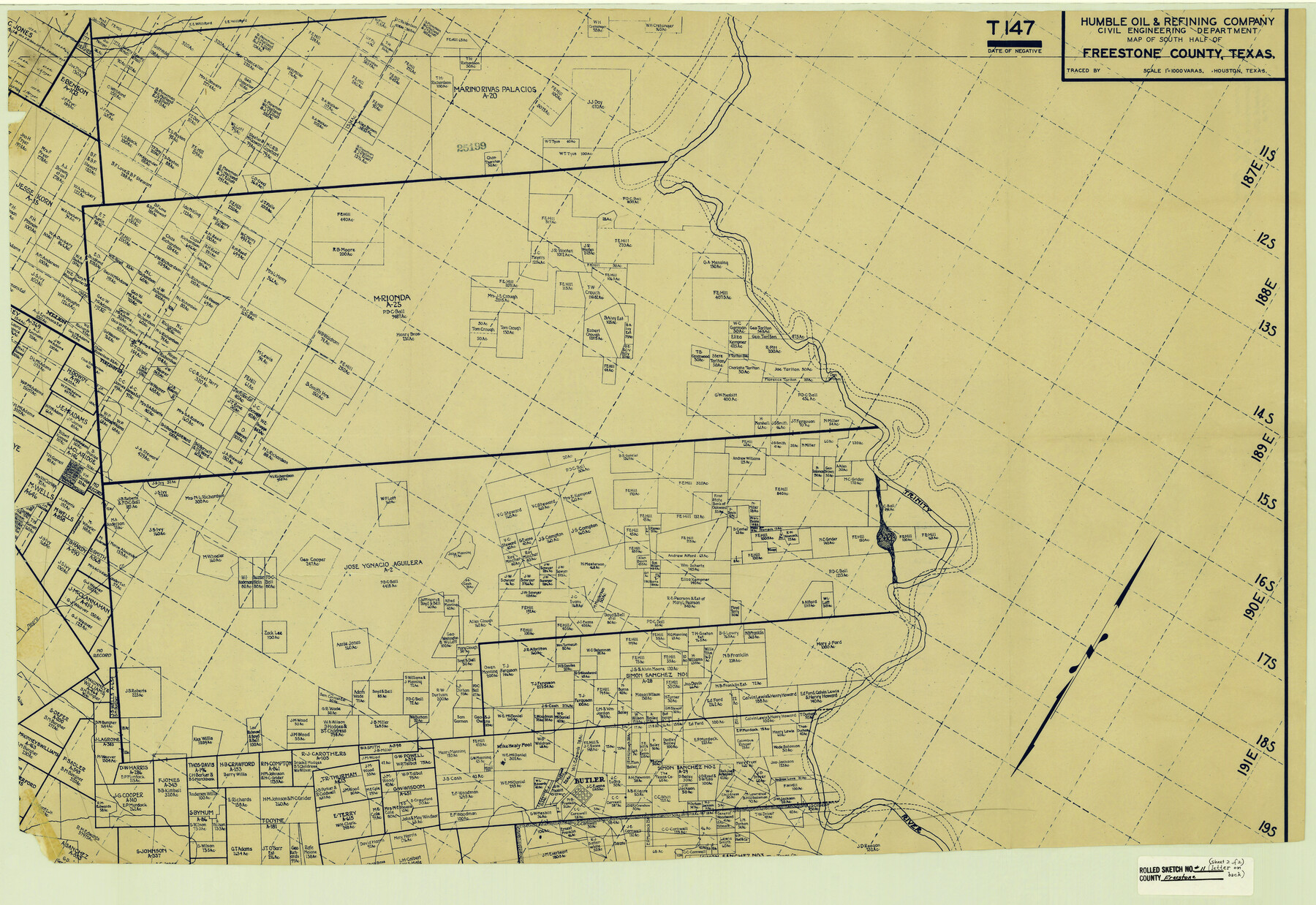
[Part of old ownership map of Freestone County showing SE part of county]
-
Map/Doc
5912
-
Collection
General Map Collection
-
Counties
Freestone
-
Subjects
Surveying Rolled Sketch
-
Height x Width
23.3 x 33.9 inches
59.2 x 86.1 cm
-
Medium
blueprint/diazo
-
Scale
1" = 1000 varas
-
Comments
To view letter on verso, click the "Download PDF" link above.
Related maps
Freestone County Rolled Sketch 11

Print $20.00
- Digital $50.00
Freestone County Rolled Sketch 11
1934
Size 17.9 x 34.1 inches
Map/Doc 5911
Part of: General Map Collection
Edwards County Sketch File 35a

Print $20.00
- Digital $50.00
Edwards County Sketch File 35a
1928
Size 33.0 x 23.5 inches
Map/Doc 11435
Fractional Township No. 7 South Range No. 7 West of the Indian Meridian, Indian Territory

Print $20.00
- Digital $50.00
Fractional Township No. 7 South Range No. 7 West of the Indian Meridian, Indian Territory
1898
Size 19.2 x 24.4 inches
Map/Doc 75168
Terrell County Rolled Sketch 53

Print $20.00
- Digital $50.00
Terrell County Rolled Sketch 53
Size 33.1 x 24.2 inches
Map/Doc 7971
Flight Mission No. CRC-3R, Frame 195, Chambers County

Print $20.00
- Digital $50.00
Flight Mission No. CRC-3R, Frame 195, Chambers County
1956
Size 18.5 x 22.2 inches
Map/Doc 84850

Jasper County Sketch File 32

Print $20.00
- Digital $50.00
Jasper County Sketch File 32
1906
Size 28.0 x 22.3 inches
Map/Doc 11853
Henderson County Working Sketch 41

Print $20.00
- Digital $50.00
Henderson County Working Sketch 41
1985
Size 28.8 x 17.0 inches
Map/Doc 66174
Harris County Historic Topographic 34

Print $20.00
- Digital $50.00
Harris County Historic Topographic 34
1915
Size 19.7 x 23.7 inches
Map/Doc 65845
Pecos County Rolled Sketch 39

Print $20.00
- Digital $50.00
Pecos County Rolled Sketch 39
1908
Size 21.8 x 33.2 inches
Map/Doc 7217
Flight Mission No. CRC-2R, Frame 63, Chambers County

Print $20.00
- Digital $50.00
Flight Mission No. CRC-2R, Frame 63, Chambers County
1956
Size 18.8 x 22.4 inches
Map/Doc 84734
Flight Mission No. DIX-6P, Frame 202, Aransas County

Print $20.00
- Digital $50.00
Flight Mission No. DIX-6P, Frame 202, Aransas County
1956
Size 19.2 x 22.7 inches
Map/Doc 83864
Bee County Boundary File 6

Print $4.00
- Digital $50.00
Bee County Boundary File 6
Size 10.4 x 7.9 inches
Map/Doc 50458
You may also like
Reagan County Working Sketch 2

Print $20.00
- Digital $50.00
Reagan County Working Sketch 2
1919
Size 28.5 x 19.6 inches
Map/Doc 71842
Map of the State of Texas

Print $20.00
- Digital $50.00
Map of the State of Texas
1876
Size 13.0 x 16.3 inches
Map/Doc 95891
Johnson County Boundary File 2

Print $56.00
- Digital $50.00
Johnson County Boundary File 2
Size 9.5 x 34.9 inches
Map/Doc 55556
Phelps's National Map of the United States, a Travellers Guide. Embracing the principal railroads, canals, steamboat & stage routes, throughout the Union

Print $20.00
- Digital $50.00
Phelps's National Map of the United States, a Travellers Guide. Embracing the principal railroads, canals, steamboat & stage routes, throughout the Union
1849
Size 20.9 x 26.3 inches
Map/Doc 95901
Upton County Sketch File 10

Print $18.00
- Digital $50.00
Upton County Sketch File 10
1919
Size 13.5 x 8.7 inches
Map/Doc 38839
Winkler County Rolled Sketch 5

Print $40.00
- Digital $50.00
Winkler County Rolled Sketch 5
1927
Size 58.0 x 38.4 inches
Map/Doc 10148
State Land for Sale on Mustang Island

Print $20.00
- Digital $50.00
State Land for Sale on Mustang Island
1910
Size 20.0 x 29.5 inches
Map/Doc 91493
Panola County Working Sketch Graphic Index

Print $20.00
- Digital $50.00
Panola County Working Sketch Graphic Index
1947
Map/Doc 76660
Stephens County Sketch File 17

Print $6.00
- Digital $50.00
Stephens County Sketch File 17
1912
Size 11.2 x 8.7 inches
Map/Doc 37074
Jasper County Working Sketch 28

Print $20.00
- Digital $50.00
Jasper County Working Sketch 28
1955
Size 22.6 x 15.6 inches
Map/Doc 66490

Atascosa County Working Sketch 21

Print $20.00
- Digital $50.00
Atascosa County Working Sketch 21
1954
Size 26.0 x 22.4 inches
Map/Doc 67217