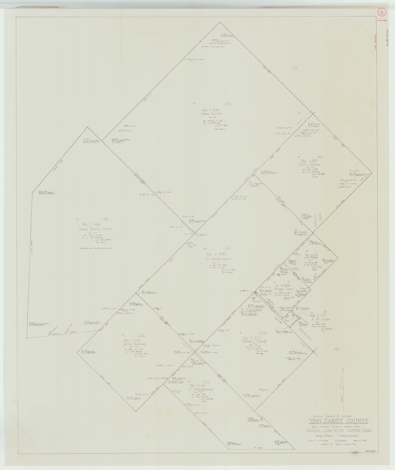
Van Zandt County Working Sketch 16
- 
                          Map/Doc72266
- 
                            CollectionGeneral Map Collection
- 
                            Object Dates9/12/1991 (Creation Date)
- 
                            People and OrganizationsJoan Kilpatrick (Draftsman)
- 
                            CountiesVan Zandt
- 
                            SubjectsSurveying Working Sketch
- 
                            Height x Width40.5 x 34.0 inches102.9 x 86.4 cm
- 
                            Scale1" = 400 varas
Part of: General Map Collection
            Wilbarger County Rolled Sketch 2


                                            Print $40.00                    
                                             -                         Digital $50.00                                    
                Wilbarger County Rolled Sketch 2
Size 36.7 x 49.6 inches
                                Map/Doc 10140
            
            Hale County Sketch File 28


                                            Print $4.00                    
                                             -                         Digital $50.00                                    
                Hale County Sketch File 28
1892
Size 11.3 x 9.0 inches
                                Map/Doc 24776
            
            Presidio County Sketch File 66


                                            Print $6.00                    
                                             -                         Digital $50.00                                    
                Presidio County Sketch File 66
1940
Size 11.4 x 8.7 inches
                                Map/Doc 34656
            
            United States - Gulf Coast Texas - Southern part of Laguna Madre


                                            Print $20.00                    
                                             -                         Digital $50.00                                    
                United States - Gulf Coast Texas - Southern part of Laguna Madre
1933
Size 27.1 x 18.3 inches
                                Map/Doc 72950
            
            Flight Mission No. BRA-16M, Frame 70, Jefferson County


                                            Print $20.00                    
                                             -                         Digital $50.00                                    
                Flight Mission No. BRA-16M, Frame 70, Jefferson County
1953
Size 18.6 x 22.3 inches
                                Map/Doc 85687
            
            Val Verde County Sketch File 55


                                            Print $44.00                    
                                             -                         Digital $50.00                                    
                Val Verde County Sketch File 55
1999
Size 11.5 x 8.9 inches
                                Map/Doc 39337
            
            Walker County Working Sketch 10


                                            Print $20.00                    
                                             -                         Digital $50.00                                    
                Walker County Working Sketch 10
1935
Size 19.3 x 19.9 inches
                                Map/Doc 72290
            
            Bell County Sketch File 27


                                            Print $4.00                    
                                             -                         Digital $50.00                                    
                Bell County Sketch File 27
1870
Size 8.9 x 9.4 inches
                                Map/Doc 14435
            
            Coryell County Working Sketch 20


                                            Print $20.00                    
                                             -                         Digital $50.00                                    
                Coryell County Working Sketch 20
1972
Size 32.2 x 22.4 inches
                                Map/Doc 68227
            
            Jeff Davis County Sketch File 12


                                            Print $38.00                    
                                             -                         Digital $50.00                                    
                Jeff Davis County Sketch File 12
1920
Size 14.6 x 9.1 inches
                                Map/Doc 27922
            
            Oldham County Working Sketch 10


                                            Print $20.00                    
                                             -                         Digital $50.00                                    
                Oldham County Working Sketch 10
1983
Size 29.6 x 44.3 inches
                                Map/Doc 71332
            
            Haskell County Working Sketch 11


                                            Print $20.00                    
                                             -                         Digital $50.00                                    
                Haskell County Working Sketch 11
1976
Size 38.0 x 33.4 inches
                                Map/Doc 66069
            You may also like
            Upton County Sketch File 19


                                            Print $20.00                    
                                             -                         Digital $50.00                                    
                Upton County Sketch File 19
1927
Size 21.2 x 21.4 inches
                                Map/Doc 12515
            
            Midland County


                                            Print $20.00                    
                                             -                         Digital $50.00                                    
                Midland County
1896
Size 23.0 x 21.1 inches
                                Map/Doc 3878
            
            Angelina County Sketch File 11f


                                            Print $4.00                    
                                             -                         Digital $50.00                                    
                Angelina County Sketch File 11f
1885
Size 8.2 x 12.6 inches
                                Map/Doc 12954
            
            Right of Way and Track Map of The Wichita Falls & Southern Railroad Company


                                            Print $40.00                    
                                             -                         Digital $50.00                                    
                Right of Way and Track Map of The Wichita Falls & Southern Railroad Company
1942
Size 24.7 x 56.3 inches
                                Map/Doc 64521
            
            Baylor County Boundary File 7


                                            Print $6.00                    
                                             -                         Digital $50.00                                    
                Baylor County Boundary File 7
Size 11.2 x 8.8 inches
                                Map/Doc 50403
            
            [Sections 61-65, I. & G. N. Block 1 and part of Block 194]
            
                                    ![91678, [Sections 61-65, I. & G. N. Block 1 and part of Block 194], Twichell Survey Records](https://historictexasmaps.com/wmedia_w700/maps/91678-1.tif.jpg) 


    ![91678, [Sections 61-65, I. & G. N. Block 1 and part of Block 194], Twichell Survey Records](https://historictexasmaps.com/wmedia_w700/maps/91678-1.tif.jpg) 
                                
            
                                            Print $20.00                    
                                             -                         Digital $50.00                                    
                [Sections 61-65, I. & G. N. Block 1 and part of Block 194]
Size 24.9 x 17.3 inches
                                Map/Doc 91678
            
            [School Leagues in Bailey and Lamb County]
            
                                    ![90987, [School Leagues in Bailey and Lamb County], Twichell Survey Records](https://historictexasmaps.com/wmedia_w700/maps/90987-2.tif.jpg) 


    ![90987, [School Leagues in Bailey and Lamb County], Twichell Survey Records](https://historictexasmaps.com/wmedia_w700/maps/90987-2.tif.jpg) 
                                
            
                                            Print $20.00                    
                                             -                         Digital $50.00                                    
                [School Leagues in Bailey and Lamb County]
Size 30.5 x 25.2 inches
                                Map/Doc 90987
            
            [Blk. B, part of Blk. M, and north line of Morris County School Land]
            
                                    ![90359, [Blk. B, part of Blk. M, and north line of Morris County School Land], Twichell Survey Records](https://historictexasmaps.com/wmedia_w700/maps/90359-1.tif.jpg) 


    ![90359, [Blk. B, part of Blk. M, and north line of Morris County School Land], Twichell Survey Records](https://historictexasmaps.com/wmedia_w700/maps/90359-1.tif.jpg) 
                                
            
                                            Print $20.00                    
                                             -                         Digital $50.00                                    
                [Blk. B, part of Blk. M, and north line of Morris County School Land]
Size 23.9 x 22.7 inches
                                Map/Doc 90359
            
            Erath County Working Sketch 27


                                            Print $20.00                    
                                             -                         Digital $50.00                                    
                Erath County Working Sketch 27
1970
Size 26.6 x 24.0 inches
                                Map/Doc 69108
            
            Gulf, Texas & Western Railway


                                            Print $40.00                    
                                             -                         Digital $50.00                                    
                Gulf, Texas & Western Railway
1909
Size 18.7 x 103.5 inches
                                Map/Doc 64431
            
            Texas-Oklahoma Boundary Line: brief summary of the lands surveyed and the lands not surveyed in the dispute between Oklahoma vs. Texas


                                            Print $356.00                    
                                             -                         Digital $50.00                                    
                Texas-Oklahoma Boundary Line: brief summary of the lands surveyed and the lands not surveyed in the dispute between Oklahoma vs. Texas
1923
Size 6.0 x 9.2 inches
                                Map/Doc 3061
             
                        ![92955, [Block 4X], Twichell Survey Records](https://historictexasmaps.com/wmedia_w700/maps/92955-1.tif.jpg)