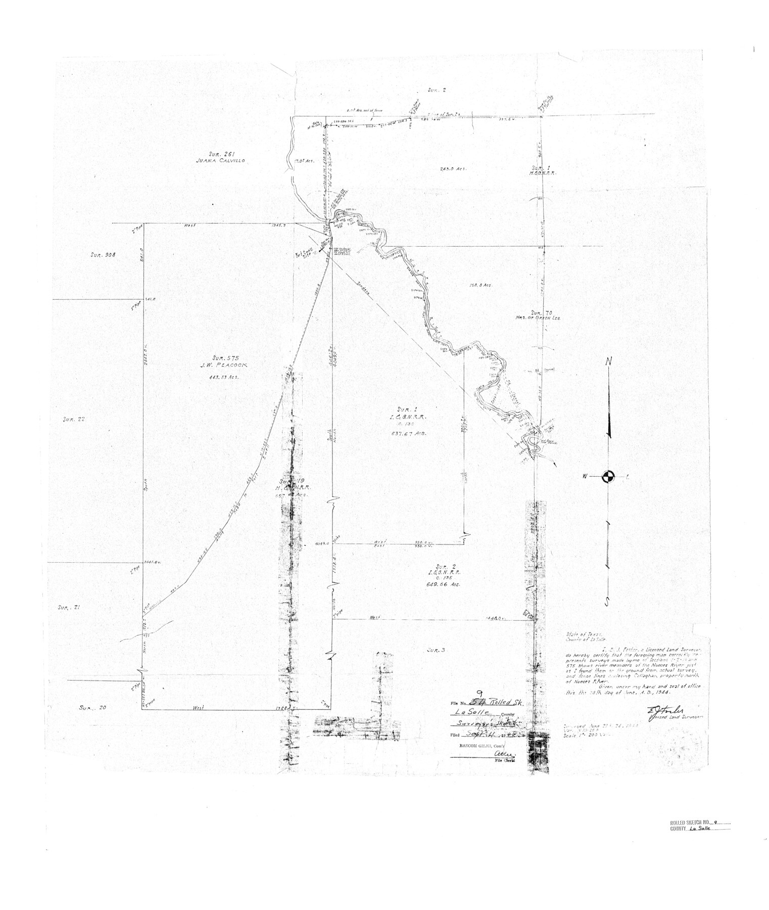
La Salle County Rolled Sketch 9
[Sketch of area in south part of county on Nueces River, La Salle County, Texas]
-
Map/Doc
6572
-
Collection
General Map Collection
-
Object Dates
1944/6/28 (Creation Date)
1944/9/11 (File Date)
1944/6/24 (Survey Date)
-
People and Organizations
E.J. Foster (Surveyor/Engineer)
-
Counties
La Salle
-
Subjects
Surveying Rolled Sketch
-
Height x Width
32.7 x 27.7 inches
83.1 x 70.4 cm
-
Scale
1" = 200 varas
-
Comments
See Webb County Sketch File 61 (39859) for surveyor's statement and see Webb County Rolled Sketch 53 (49483 and 63914) for related sketch.
Related maps
Webb County Sketch File 61

Print $6.00
- Digital $50.00
Webb County Sketch File 61
1944
Size 14.5 x 8.8 inches
Map/Doc 39859
Webb County Rolled Sketch 53

Print $40.00
- Digital $50.00
Webb County Rolled Sketch 53
1944
Size 83.5 x 28.6 inches
Map/Doc 49483
Webb County Rolled Sketch 53

Print $40.00
- Digital $50.00
Webb County Rolled Sketch 53
1944
Size 84.0 x 32.3 inches
Map/Doc 63914
Part of: General Map Collection
Kerr County Working Sketch 24

Print $20.00
- Digital $50.00
Kerr County Working Sketch 24
1966
Size 35.9 x 38.3 inches
Map/Doc 70055
Pecos County Working Sketch 62

Print $40.00
- Digital $50.00
Pecos County Working Sketch 62
1952
Size 32.3 x 59.1 inches
Map/Doc 71534
Kinney County Sketch File 38

Print $8.00
- Digital $50.00
Kinney County Sketch File 38
1882
Size 14.3 x 8.7 inches
Map/Doc 29188
Anderson County Working Sketch 44

Print $20.00
- Digital $50.00
Anderson County Working Sketch 44
1991
Size 27.7 x 32.3 inches
Map/Doc 67044
Bandera County Rolled Sketch 10

Print $20.00
- Digital $50.00
Bandera County Rolled Sketch 10
1998
Size 35.4 x 38.1 inches
Map/Doc 8440
Roberts County Sketch File 4

Print $12.00
- Digital $50.00
Roberts County Sketch File 4
1889
Size 8.7 x 7.8 inches
Map/Doc 35306
Bell County Sketch File 25

Print $8.00
- Digital $50.00
Bell County Sketch File 25
Size 5.1 x 5.3 inches
Map/Doc 14420
Calhoun County Rolled Sketch 14

Print $20.00
- Digital $50.00
Calhoun County Rolled Sketch 14
Size 21.4 x 40.0 inches
Map/Doc 5457
Hunt County Working Sketch 1

Print $20.00
- Digital $50.00
Hunt County Working Sketch 1
Size 18.2 x 17.2 inches
Map/Doc 66348
Culberson County Working Sketch 69

Print $40.00
- Digital $50.00
Culberson County Working Sketch 69
1975
Size 49.4 x 32.2 inches
Map/Doc 68523
Aransas County Sketch File 27

Print $23.00
- Digital $50.00
Aransas County Sketch File 27
Size 12.2 x 18.2 inches
Map/Doc 13224
Index sheet to accompany map of survey for connecting the inland waters along margin of the Gulf of Mexico from Donaldsonville in Louisiana to the Rio Grande River in Texas

Print $20.00
- Digital $50.00
Index sheet to accompany map of survey for connecting the inland waters along margin of the Gulf of Mexico from Donaldsonville in Louisiana to the Rio Grande River in Texas
1874
Size 18.2 x 27.1 inches
Map/Doc 72696
You may also like
Freestone County Rolled Sketch 13A

Print $20.00
- Digital $50.00
Freestone County Rolled Sketch 13A
1990
Size 45.2 x 33.7 inches
Map/Doc 5914
Nacogdoches County Working Sketch 1

Print $20.00
- Digital $50.00
Nacogdoches County Working Sketch 1
Size 27.8 x 35.8 inches
Map/Doc 71217
Bandera County Working Sketch 36

Print $20.00
- Digital $50.00
Bandera County Working Sketch 36
1966
Size 22.5 x 29.5 inches
Map/Doc 67632
Borden County Boundary File 4

Print $2.00
- Digital $50.00
Borden County Boundary File 4
Size 13.3 x 8.3 inches
Map/Doc 50636
Presidio County Rolled Sketch 85

Print $20.00
- Digital $50.00
Presidio County Rolled Sketch 85
1930
Size 28.3 x 27.3 inches
Map/Doc 7371
Real County Working Sketch 63

Print $20.00
- Digital $50.00
Real County Working Sketch 63
1967
Size 28.8 x 32.3 inches
Map/Doc 71955
Flight Mission No. CRC-4R, Frame 70, Chambers County

Print $20.00
- Digital $50.00
Flight Mission No. CRC-4R, Frame 70, Chambers County
1956
Size 18.7 x 22.4 inches
Map/Doc 84874
Chambers County Sketch File 50

Print $49.00
- Digital $50.00
Chambers County Sketch File 50
1917
Size 14.4 x 8.8 inches
Map/Doc 18048
Map of Texas. The Proposed Reoccupation of the Rio Grande -- Its Importance to the Union

Print $20.00
Map of Texas. The Proposed Reoccupation of the Rio Grande -- Its Importance to the Union
1863
Size 14.1 x 8.7 inches
Map/Doc 76263
Blanco County Sketch File 44

Print $40.00
- Digital $50.00
Blanco County Sketch File 44
1902
Size 17.6 x 13.7 inches
Map/Doc 14669
Cameron County Sketch File 16

Print $18.00
- Digital $50.00
Cameron County Sketch File 16
1998
Size 11.2 x 8.6 inches
Map/Doc 76334
Red River County Working Sketch 30

Print $20.00
- Digital $50.00
Red River County Working Sketch 30
1962
Size 25.2 x 22.8 inches
Map/Doc 72013