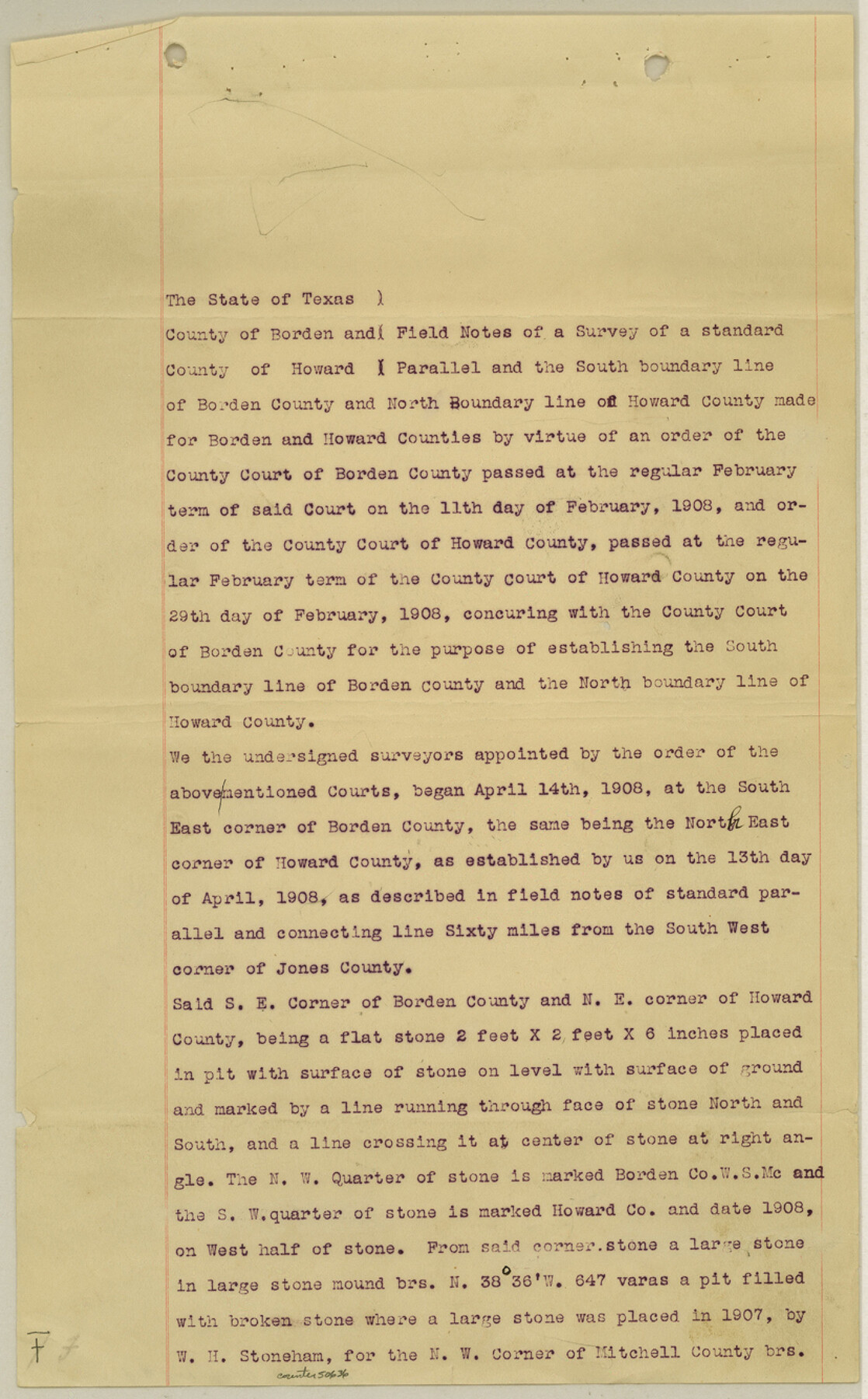
Borden County Boundary File 4
Plat of South Boundary Line of Borden and North Boundary Line of Howard County
-
Map/Doc
50636
-
Collection
General Map Collection
-
Counties
Borden
-
Subjects
County Boundaries
-
Height x Width
13.3 x 8.3 inches
33.8 x 21.1 cm
Part of: General Map Collection
Dallas, Ft. Worth, & Vicinity, Texas - Regional Map

Dallas, Ft. Worth, & Vicinity, Texas - Regional Map
1997
Size 25.9 x 36.7 inches
Map/Doc 97288
Terrell County Rolled Sketch 40

Print $20.00
- Digital $50.00
Terrell County Rolled Sketch 40
1943
Size 16.7 x 18.1 inches
Map/Doc 7944
McCulloch County Boundary File 1

Print $40.00
- Digital $50.00
McCulloch County Boundary File 1
Size 9.2 x 33.6 inches
Map/Doc 56906
Right of Way and Track Map, The Missouri, Kansas and Texas Ry. of Texas operated by the Missouri, Kansas and Texas Ry. of Texas, Henrietta Division

Print $40.00
- Digital $50.00
Right of Way and Track Map, The Missouri, Kansas and Texas Ry. of Texas operated by the Missouri, Kansas and Texas Ry. of Texas, Henrietta Division
1918
Size 25.1 x 56.4 inches
Map/Doc 64074
Texas Official Highway Travel Map

Texas Official Highway Travel Map
Size 27.3 x 36.4 inches
Map/Doc 94308
Presidio County Working Sketch 68

Print $20.00
- Digital $50.00
Presidio County Working Sketch 68
1960
Size 45.8 x 33.1 inches
Map/Doc 71745
Hays County Rolled Sketch 32

Print $20.00
- Digital $50.00
Hays County Rolled Sketch 32
2003
Size 15.6 x 20.0 inches
Map/Doc 78489
Rio Grande, Raymondville Sheet

Print $20.00
- Digital $50.00
Rio Grande, Raymondville Sheet
1925
Size 43.7 x 17.8 inches
Map/Doc 65127


Sterling County

Print $40.00
- Digital $50.00
Sterling County
1926
Size 48.5 x 34.7 inches
Map/Doc 63048
Garza County Sketch File 22

Print $40.00
- Digital $50.00
Garza County Sketch File 22
Size 51.9 x 24.1 inches
Map/Doc 10464
You may also like
Dimmit County Working Sketch 31

Print $20.00
- Digital $50.00
Dimmit County Working Sketch 31
1959
Size 26.3 x 42.8 inches
Map/Doc 68692
Gray's railroad map of Texas.

Print $20.00
Gray's railroad map of Texas.
1878
Size 26.4 x 16.1 inches
Map/Doc 93597
Young County Working Sketch 16

Print $20.00
- Digital $50.00
Young County Working Sketch 16
1955
Size 23.8 x 21.7 inches
Map/Doc 62039
Controlled Mosaic by Jack Amman Photogrammetric Engineers, Inc - Sheet 42

Print $20.00
- Digital $50.00
Controlled Mosaic by Jack Amman Photogrammetric Engineers, Inc - Sheet 42
1954
Size 20.0 x 24.0 inches
Map/Doc 83499
Williamson County Sketch File 24

Print $12.00
- Digital $50.00
Williamson County Sketch File 24
1877
Size 12.8 x 8.1 inches
Map/Doc 40355
Garza County Sketch File C1

Print $10.00
- Digital $50.00
Garza County Sketch File C1
1900
Size 12.9 x 8.1 inches
Map/Doc 24015
Edwards County Working Sketch 16

Print $20.00
- Digital $50.00
Edwards County Working Sketch 16
1929
Size 21.5 x 21.5 inches
Map/Doc 68892
North Sulphur River, Mt. Joy Sheet

Print $20.00
- Digital $50.00
North Sulphur River, Mt. Joy Sheet
1926
Size 18.4 x 21.6 inches
Map/Doc 78333
Crockett County Rolled Sketch 3

Print $20.00
- Digital $50.00
Crockett County Rolled Sketch 3
1886
Size 18.1 x 22.9 inches
Map/Doc 5579
Brazoria County NRC Article 33.136 Sketch 9

Print $24.00
- Digital $50.00
Brazoria County NRC Article 33.136 Sketch 9
2007
Size 24.2 x 34.1 inches
Map/Doc 87929
Donley County Boundary File 2

Print $10.00
- Digital $50.00
Donley County Boundary File 2
Size 8.7 x 11.3 inches
Map/Doc 52619
Map of Parker County

Print $20.00
- Digital $50.00
Map of Parker County
1879
Size 23.9 x 19.0 inches
Map/Doc 3947