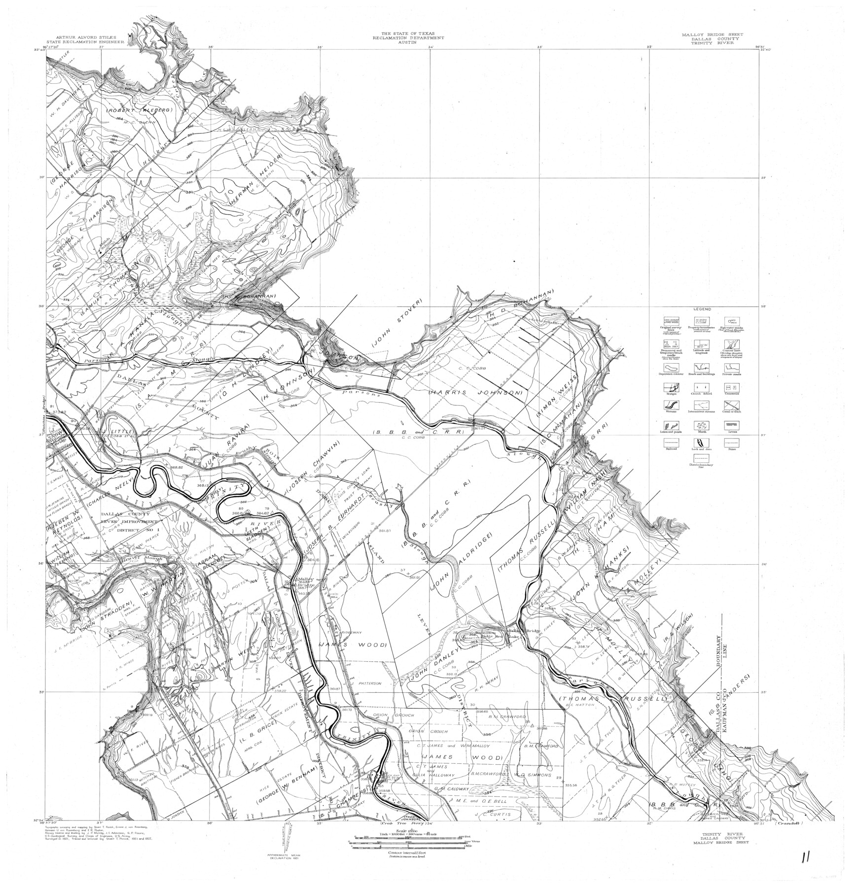
Trinity River, Malloy Bridge Sheet
-
Map/Doc
65189
-
Collection
General Map Collection
-
Object Dates
1922 (Creation Date)
-
People and Organizations
Texas State Reclamation Department (Publisher)
Stuart T. Penick (Compiler)
Stuart T. Penick (Draftsman)
Stuart T. Penick (Surveyor/Engineer)
E.J. von Rosenberg (Surveyor/Engineer)
F.R. Poston (Surveyor/Engineer)
H.U. von Rosenberg (Surveyor/Engineer)
-
Counties
Dallas
-
Subjects
River Surveys Topographic
-
Height x Width
41.7 x 40.2 inches
105.9 x 102.1 cm
-
Comments
Malloy Bridge Sheet located east of the Hutchins Bridge Sheet and north of the Crabtree Ferry Sheet and the Crandall Sheet.
Part of: General Map Collection
Montague County Sketch File 10

Print $4.00
- Digital $50.00
Montague County Sketch File 10
1873
Size 7.9 x 11.8 inches
Map/Doc 31732
Reeves County Sketch File 10

Print $20.00
- Digital $50.00
Reeves County Sketch File 10
Size 17.0 x 32.0 inches
Map/Doc 12244
Edwards County Sketch File 44

Print $4.00
- Digital $50.00
Edwards County Sketch File 44
1948
Size 11.4 x 8.9 inches
Map/Doc 21777
[William Steele Survey near Copano Bay]
![2082, [William Steele Survey near Copano Bay], General Map Collection](https://historictexasmaps.com/wmedia_w700/maps/2082.tif.jpg)
Print $20.00
- Digital $50.00
[William Steele Survey near Copano Bay]
1927
Size 26.1 x 18.4 inches
Map/Doc 2082
Taylor County Working Sketch 14

Print $20.00
- Digital $50.00
Taylor County Working Sketch 14
1959
Size 26.8 x 21.4 inches
Map/Doc 69624
Hall County Sketch File 3

Print $3.00
- Digital $50.00
Hall County Sketch File 3
Size 11.7 x 17.1 inches
Map/Doc 24799
Map of Nacogdoches County

Print $20.00
- Digital $50.00
Map of Nacogdoches County
1846
Size 44.7 x 40.0 inches
Map/Doc 87355

Borden County Boundary File 5

Print $58.00
- Digital $50.00
Borden County Boundary File 5
Size 14.3 x 8.6 inches
Map/Doc 50650
Newton County Sketch File 22

Print $4.00
- Digital $50.00
Newton County Sketch File 22
1890
Size 14.2 x 8.7 inches
Map/Doc 32401
Brazos River, Brazos River Sheet 1

Print $4.00
- Digital $50.00
Brazos River, Brazos River Sheet 1
1926
Size 21.5 x 25.4 inches
Map/Doc 65293
Montgomery County Working Sketch 31

Print $20.00
- Digital $50.00
Montgomery County Working Sketch 31
Size 24.7 x 18.7 inches
Map/Doc 71138
You may also like
Reagan County Sketch File 25

Print $20.00
- Digital $50.00
Reagan County Sketch File 25
1941
Size 18.1 x 23.9 inches
Map/Doc 12222
[Sketch for Mineral Application 24072, San Jacinto River]
![65589, [Sketch for Mineral Application 24072, San Jacinto River], General Map Collection](https://historictexasmaps.com/wmedia_w700/maps/65589.tif.jpg)
Print $20.00
- Digital $50.00
[Sketch for Mineral Application 24072, San Jacinto River]
1929
Size 29.6 x 14.7 inches
Map/Doc 65589
Terrell County Sketch File 27

Print $10.00
- Digital $50.00
Terrell County Sketch File 27
1936
Size 8.7 x 11.3 inches
Map/Doc 37971
Tabula Terre Nove

Print $20.00
- Digital $50.00
Tabula Terre Nove
1513
Size 18.7 x 24.6 inches
Map/Doc 93800
Stonewall County Rolled Sketch 22

Print $20.00
- Digital $50.00
Stonewall County Rolled Sketch 22
1951
Size 33.2 x 30.9 inches
Map/Doc 9961
Hays County Sketch File 27

Print $6.00
- Digital $50.00
Hays County Sketch File 27
Size 11.2 x 8.8 inches
Map/Doc 26252
Navarro County Sketch File 20

Print $14.00
- Digital $50.00
Navarro County Sketch File 20
1967
Size 14.3 x 8.8 inches
Map/Doc 32343
Edwards County Working Sketch 108

Print $40.00
- Digital $50.00
Edwards County Working Sketch 108
1972
Size 61.2 x 37.1 inches
Map/Doc 68984
Preliminary map of Brazos Island

Print $20.00
- Digital $50.00
Preliminary map of Brazos Island
1863
Size 25.2 x 18.1 inches
Map/Doc 72924
Crockett County Sketch File 95

Print $24.00
- Digital $50.00
Crockett County Sketch File 95
Size 11.2 x 8.9 inches
Map/Doc 19952
Galveston Bay and Approaches

Print $20.00
- Digital $50.00
Galveston Bay and Approaches
1957
Size 43.6 x 32.7 inches
Map/Doc 69877
Hidalgo County Rolled Sketch 17

Print $40.00
- Digital $50.00
Hidalgo County Rolled Sketch 17
1963
Size 68.4 x 42.9 inches
Map/Doc 9172