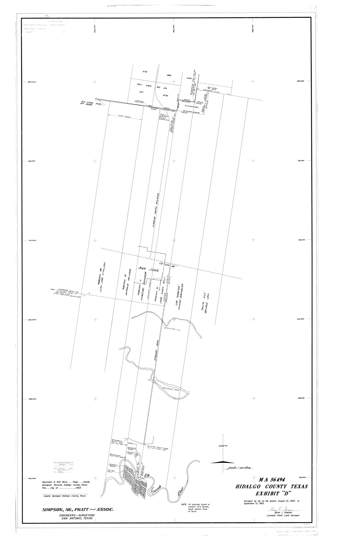
Hidalgo County Rolled Sketch 17
MA-56494, Hidalgo County, Texas, Exhibit "D"
-
Map/Doc
9172
-
Collection
General Map Collection
-
Object Dates
1963/9/13 (Creation Date)
1963/10/29 (File Date)
-
People and Organizations
Bryon L. Simpson (Surveyor/Engineer)
-
Counties
Hidalgo
-
Subjects
Surveying Rolled Sketch
-
Height x Width
68.4 x 42.9 inches
173.7 x 109.0 cm
-
Scale
1" = 600 varas
Part of: General Map Collection

Limestone County Working Sketch 20

Print $20.00
- Digital $50.00
Limestone County Working Sketch 20
1976
Size 41.5 x 42.3 inches
Map/Doc 70570
PSL Field Notes for Blocks A42 through A55 in Andrews County

PSL Field Notes for Blocks A42 through A55 in Andrews County
Map/Doc 81644
Aransas County NRC Article 33.136 Sketch 5

Print $20.00
- Digital $50.00
Aransas County NRC Article 33.136 Sketch 5
2005
Size 18.5 x 24.7 inches
Map/Doc 83521
Bexar County Sketch File 36b

Print $40.00
- Digital $50.00
Bexar County Sketch File 36b
Size 18.6 x 20.2 inches
Map/Doc 10921
Presidio County Rolled Sketch 66

Print $20.00
- Digital $50.00
Presidio County Rolled Sketch 66
1920
Size 19.4 x 37.5 inches
Map/Doc 7357
Bryant's Railroad Guide, the Tourists' and Emigrants' Hand-book of Travel

Print $260.00
- Digital $50.00
Bryant's Railroad Guide, the Tourists' and Emigrants' Hand-book of Travel
1875
Size 9.3 x 6.0 inches
Map/Doc 93627
Plat showing surveys made for N. Vasquez, Sr. of Casa Piedra, Texas in Block 312, T. C. Ry. Co.

Print $20.00
- Digital $50.00
Plat showing surveys made for N. Vasquez, Sr. of Casa Piedra, Texas in Block 312, T. C. Ry. Co.
1947
Size 16.5 x 22.3 inches
Map/Doc 2062
Jeff Davis County Rolled Sketch 27

Print $20.00
- Digital $50.00
Jeff Davis County Rolled Sketch 27
1969
Size 29.3 x 36.8 inches
Map/Doc 6375
Culberson County Working Sketch 8

Print $20.00
- Digital $50.00
Culberson County Working Sketch 8
1914
Size 35.4 x 36.0 inches
Map/Doc 68460
Irion County Boundary File 4a

Print $40.00
- Digital $50.00
Irion County Boundary File 4a
Size 8.6 x 38.7 inches
Map/Doc 55361
Wharton County

Print $40.00
- Digital $50.00
Wharton County
1946
Size 43.4 x 49.0 inches
Map/Doc 63119
You may also like
Map of Cass County

Print $20.00
- Digital $50.00
Map of Cass County
1847
Size 21.3 x 18.4 inches
Map/Doc 3368
Hardin County Sketch File 71

Print $94.00
- Digital $50.00
Hardin County Sketch File 71
1997
Size 11.4 x 8.8 inches
Map/Doc 25259
Fort Worth, Tex. "The Queen of the Prairies," County Seat of Tarrant County

Print $20.00
Fort Worth, Tex. "The Queen of the Prairies," County Seat of Tarrant County
1886
Size 26.0 x 33.3 inches
Map/Doc 89082
[Blocks 56 and 57, Townships 1 and 2]
![91315, [Blocks 56 and 57, Townships 1 and 2], Twichell Survey Records](https://historictexasmaps.com/wmedia_w700/maps/91315-1.tif.jpg)
Print $20.00
- Digital $50.00
[Blocks 56 and 57, Townships 1 and 2]
Size 19.3 x 20.5 inches
Map/Doc 91315
Galveston County NRC Article 33.136 Sketch 13

Print $20.00
- Digital $50.00
Galveston County NRC Article 33.136 Sketch 13
2002
Size 17.9 x 22.4 inches
Map/Doc 77044
General Highway Map. Detail of Cities and Towns in Smith County, Texas. City Map, Tyler, Smith County, Texas

Print $20.00
General Highway Map. Detail of Cities and Towns in Smith County, Texas. City Map, Tyler, Smith County, Texas
1961
Size 18.1 x 24.9 inches
Map/Doc 79656
[Maps of surveys in Reeves & Culberson Cos]
![61130, [Maps of surveys in Reeves & Culberson Cos], General Map Collection](https://historictexasmaps.com/wmedia_w700/maps/61130.tif.jpg)
Print $20.00
- Digital $50.00
[Maps of surveys in Reeves & Culberson Cos]
1937
Size 30.7 x 24.9 inches
Map/Doc 61130
Wise County Working Sketch 31

Print $20.00
- Digital $50.00
Wise County Working Sketch 31
2009
Size 27.9 x 37.5 inches
Map/Doc 89985
El Paso County Boundary File 1

Print $48.00
- Digital $50.00
El Paso County Boundary File 1
Size 12.3 x 35.0 inches
Map/Doc 53015
Mills County Boundary File 7

Print $2.00
- Digital $50.00
Mills County Boundary File 7
Size 14.2 x 8.6 inches
Map/Doc 57312
Kimble County Working Sketch 28

Print $20.00
- Digital $50.00
Kimble County Working Sketch 28
1938
Size 29.4 x 23.2 inches
Map/Doc 70096
Military Reconnaissance of the Arkansas Rio Del Norte and Rio Gila

Print $40.00
- Digital $50.00
Military Reconnaissance of the Arkansas Rio Del Norte and Rio Gila
1847
Size 33.0 x 72.2 inches
Map/Doc 552