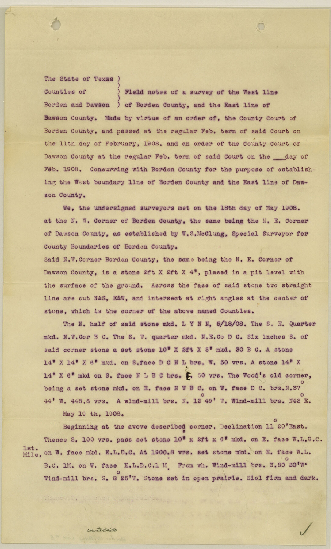
Borden County Boundary File 5
Map of West Line of Borden County and East Line of Dawson County, Texas
-
Map/Doc
50650
-
Collection
General Map Collection
-
Counties
Borden
-
Subjects
County Boundaries
-
Height x Width
14.3 x 8.6 inches
36.3 x 21.8 cm
Part of: General Map Collection
Navigation Maps of Gulf Intracoastal Waterway, Port Arthur to Brownsville, Texas

Print $4.00
- Digital $50.00
Navigation Maps of Gulf Intracoastal Waterway, Port Arthur to Brownsville, Texas
1951
Size 16.7 x 21.4 inches
Map/Doc 65446
Hays County Sketch File 28

Print $20.00
- Digital $50.00
Hays County Sketch File 28
1912
Size 26.0 x 20.0 inches
Map/Doc 11750
PSL Field Notes for Blocks 77 through 86 in Culberson County and Blocks 73 through 76 in Hudspeth County

PSL Field Notes for Blocks 77 through 86 in Culberson County and Blocks 73 through 76 in Hudspeth County
Map/Doc 81663
Bandera County Working Sketch 32

Print $20.00
- Digital $50.00
Bandera County Working Sketch 32
1956
Size 22.7 x 18.4 inches
Map/Doc 67628
Archer County Sketch File 21

Print $40.00
- Digital $50.00
Archer County Sketch File 21
Size 30.3 x 19.8 inches
Map/Doc 10830
Val Verde County Sketch File 25

Print $20.00
- Digital $50.00
Val Verde County Sketch File 25
Size 19.8 x 24.6 inches
Map/Doc 12572
Supreme Court of the United States, October Term, 1923, No. 15, Original - The State of Oklahoma, Complainant vs. The State of Texas, Defendant, The United States, Intervener; Report of the Boundary Commissioners

Print $20.00
- Digital $50.00
Supreme Court of the United States, October Term, 1923, No. 15, Original - The State of Oklahoma, Complainant vs. The State of Texas, Defendant, The United States, Intervener; Report of the Boundary Commissioners
1923
Size 34.2 x 33.9 inches
Map/Doc 75133
Jack County Working Sketch 19

Print $20.00
- Digital $50.00
Jack County Working Sketch 19
1989
Size 21.5 x 29.4 inches
Map/Doc 66445
Flight Mission No. DCL-7C, Frame 110, Kenedy County

Print $20.00
- Digital $50.00
Flight Mission No. DCL-7C, Frame 110, Kenedy County
1943
Size 18.5 x 22.3 inches
Map/Doc 86075
Young County Boundary File 1

Print $8.00
- Digital $50.00
Young County Boundary File 1
Size 10.3 x 8.2 inches
Map/Doc 60198
[Map Showing Panhandle Counties in Texas]
![2087, [Map Showing Panhandle Counties in Texas], General Map Collection](https://historictexasmaps.com/wmedia_w700/maps/2087.tif.jpg)
Print $20.00
- Digital $50.00
[Map Showing Panhandle Counties in Texas]
1876
Size 27.3 x 27.9 inches
Map/Doc 2087
Travis County Sketch File 11

Print $4.00
- Digital $50.00
Travis County Sketch File 11
1872
Size 11.4 x 8.8 inches
Map/Doc 38300
You may also like
Schleicher County Working Sketch 11

Print $20.00
- Digital $50.00
Schleicher County Working Sketch 11
1924
Size 18.9 x 13.8 inches
Map/Doc 63813
Archer County Sketch File B

Print $18.00
- Digital $50.00
Archer County Sketch File B
1892
Size 14.2 x 8.8 inches
Map/Doc 13566
Acreage in Texas by Counties

Acreage in Texas by Counties
1983
Size 10.3 x 11.8 inches
Map/Doc 97033
Galveston County Sketch File 71

Print $59.00
- Digital $50.00
Galveston County Sketch File 71
1994
Size 11.0 x 17.0 inches
Map/Doc 23941
Travis County Working Sketch 17

Print $20.00
- Digital $50.00
Travis County Working Sketch 17
1944
Size 27.8 x 23.3 inches
Map/Doc 69401
Sterling County Sketch File 18

Print $8.00
- Digital $50.00
Sterling County Sketch File 18
1939
Size 11.2 x 8.7 inches
Map/Doc 37161
Prison Property, Walker Co.

Print $20.00
- Digital $50.00
Prison Property, Walker Co.
Size 34.2 x 24.7 inches
Map/Doc 94283

Texas - Rand McNally Indexed Pocket Map - Tourists' and Shippers' Guide - Main Highways, Railroads, and Electric Lines, Counties, Cities, Towns, Villages, Post Offices, Lakes, Rivers, etc.

Texas - Rand McNally Indexed Pocket Map - Tourists' and Shippers' Guide - Main Highways, Railroads, and Electric Lines, Counties, Cities, Towns, Villages, Post Offices, Lakes, Rivers, etc.
1924
Map/Doc 95854
La Salle County Rolled Sketch 15

Print $20.00
- Digital $50.00
La Salle County Rolled Sketch 15
Size 22.0 x 32.4 inches
Map/Doc 6579
General Highway Map, El Paso County, Texas

Print $20.00
General Highway Map, El Paso County, Texas
1961
Size 18.1 x 24.5 inches
Map/Doc 79456
[Township 3 North, Blocks 31 and 32]
![91213, [Township 3 North, Blocks 31 and 32], Twichell Survey Records](https://historictexasmaps.com/wmedia_w700/maps/91213-1.tif.jpg)
Print $3.00
- Digital $50.00
[Township 3 North, Blocks 31 and 32]
Size 12.5 x 10.8 inches
Map/Doc 91213