Reagan County Sketch File 25
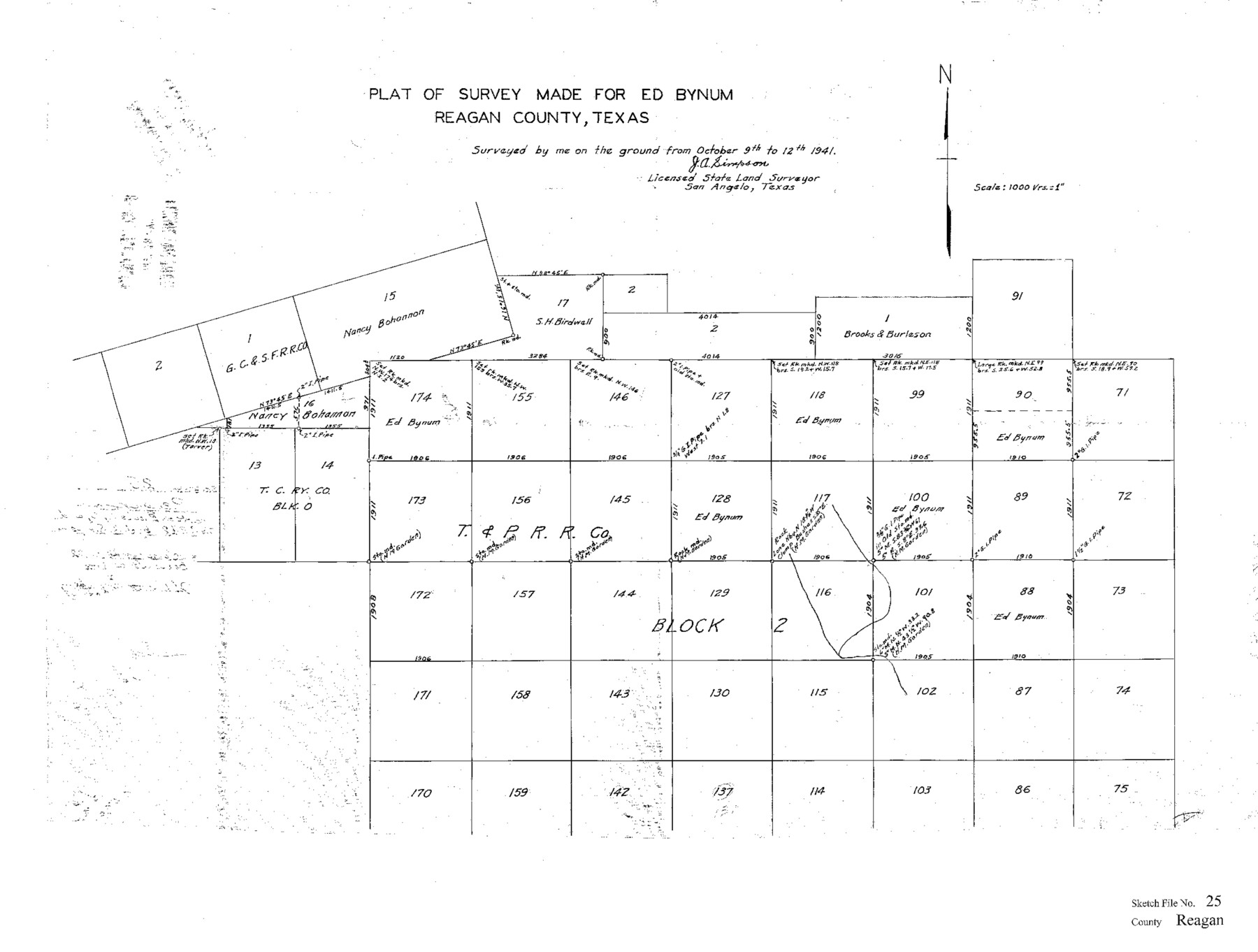
Plat of Survey [Showing T&PRRCo. Block 2], Reagan County, Texas
-
Map/Doc
12222
-
Collection
General Map Collection
-
Object Dates
1941 (Creation Date)
1942/1/28 (File Date)
1941/10/12 (Survey Date)
-
People and Organizations
J.A. Simpson (Surveyor/Engineer)
-
Counties
Reagan
-
Subjects
Surveying Sketch File
-
Height x Width
18.1 x 23.9 inches
46.0 x 60.7 cm
-
Medium
paper, print
-
Scale
1" = 1000 varas
Part of: General Map Collection

1960 Texas Official Highway Travel Map

Digital $50.00
1960 Texas Official Highway Travel Map
Size 28.3 x 36.5 inches
Map/Doc 94330
Ward County Rolled Sketch 3

Print $40.00
- Digital $50.00
Ward County Rolled Sketch 3
Size 65.3 x 25.7 inches
Map/Doc 10101
Hunt County Sketch File 49

Print $4.00
- Digital $50.00
Hunt County Sketch File 49
1852
Size 7.3 x 8.9 inches
Map/Doc 27168
Pecos County Working Sketch 141

Print $20.00
- Digital $50.00
Pecos County Working Sketch 141
1941
Size 31.8 x 42.5 inches
Map/Doc 9733
Maps of Gulf Intracoastal Waterway, Texas - Sabine River to the Rio Grande and connecting waterways including ship channels

Print $20.00
- Digital $50.00
Maps of Gulf Intracoastal Waterway, Texas - Sabine River to the Rio Grande and connecting waterways including ship channels
1966
Size 14.4 x 22.2 inches
Map/Doc 61943
Matagorda County Sketch File 15

Print $48.00
- Digital $50.00
Matagorda County Sketch File 15
Size 8.7 x 11.2 inches
Map/Doc 30774
Midland County Boundary File 1a

Print $4.00
- Digital $50.00
Midland County Boundary File 1a
Size 9.5 x 6.0 inches
Map/Doc 57160
Engineer's Office, Department of the Gulf Map No. 59, Texas prepared by order of Maj. Gen. N. P. Banks under direction of Capt. P. C. Hains, U. S. Engr. & Chief Engr., Dept. of the Gulf

Print $20.00
- Digital $50.00
Engineer's Office, Department of the Gulf Map No. 59, Texas prepared by order of Maj. Gen. N. P. Banks under direction of Capt. P. C. Hains, U. S. Engr. & Chief Engr., Dept. of the Gulf
1865
Size 18.2 x 27.5 inches
Map/Doc 72716
Harris County Sketch File 1b

Print $3.00
- Digital $50.00
Harris County Sketch File 1b
Size 15.3 x 10.4 inches
Map/Doc 25330

Dimmit County Working Sketch 22

Print $20.00
- Digital $50.00
Dimmit County Working Sketch 22
1951
Size 37.3 x 38.7 inches
Map/Doc 68683
You may also like
Lee County Working Sketch 12

Print $20.00
- Digital $50.00
Lee County Working Sketch 12
1980
Size 12.3 x 16.3 inches
Map/Doc 70391
[Sketch showing details along East line of Lipscomb County]
![89968, [Sketch showing details along East line of Lipscomb County], Twichell Survey Records](https://historictexasmaps.com/wmedia_w700/maps/89968-1.tif.jpg)
Print $40.00
- Digital $50.00
[Sketch showing details along East line of Lipscomb County]
Size 9.9 x 66.3 inches
Map/Doc 89968
Brazos River Conservation and Reclamation District Official Boundary Line Survey, Parmer County

Print $20.00
- Digital $50.00
Brazos River Conservation and Reclamation District Official Boundary Line Survey, Parmer County
Size 24.9 x 36.9 inches
Map/Doc 91599
Colorado County Working Sketch 21

Print $20.00
- Digital $50.00
Colorado County Working Sketch 21
1963
Size 32.1 x 30.5 inches
Map/Doc 68121
Cass County Rolled Sketch OPD

Print $20.00
- Digital $50.00
Cass County Rolled Sketch OPD
1936
Size 29.6 x 24.9 inches
Map/Doc 5415
Territory of New Mexico

Print $20.00
- Digital $50.00
Territory of New Mexico
1903
Size 23.8 x 19.6 inches
Map/Doc 82011
Harris County Sketch File AA3

Print $8.00
- Digital $50.00
Harris County Sketch File AA3
Size 8.2 x 8.5 inches
Map/Doc 25326
Stonewall County Sketch File 14

Print $20.00
- Digital $50.00
Stonewall County Sketch File 14
1901
Size 21.5 x 18.3 inches
Map/Doc 12366
Brewster County Rolled Sketch 141

Print $20.00
- Digital $50.00
Brewster County Rolled Sketch 141
1983
Size 27.4 x 28.6 inches
Map/Doc 5309
Crane County Boundary File 1a

Print $18.00
- Digital $50.00
Crane County Boundary File 1a
Size 14.2 x 8.7 inches
Map/Doc 51960
Menard County Working Sketch 15

Print $20.00
- Digital $50.00
Menard County Working Sketch 15
1943
Size 18.6 x 20.6 inches
Map/Doc 70962
Terrell County Sketch File 22W

Print $20.00
- Digital $50.00
Terrell County Sketch File 22W
Size 19.6 x 21.7 inches
Map/Doc 12423