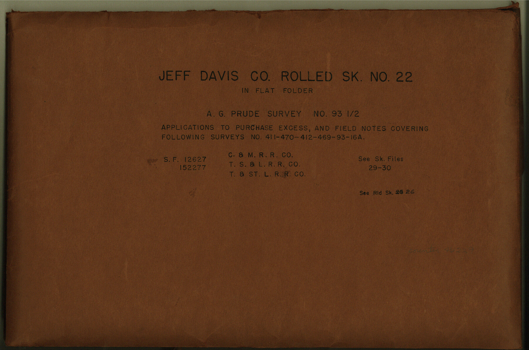
Jeff Davis County Rolled Sketch 22
[A.G. Prude survey no. 93 1/2 - applications to purchase excess, field notes covering following surveys no. 411, 470, 412, 469, 93, and 16A, and aerial photos - SF-12627, School File 152277]
-
Map/Doc
6487
-
Collection
General Map Collection
-
Counties
Jeff Davis
-
Subjects
Surveying Rolled Sketch
-
Height x Width
17.2 x 15.8 inches
43.7 x 40.1 cm
-
Medium
multi-page, multi-format
-
Comments
See Jeff Davis County Sketch File 29 (28008), Jeff Davis County Sketch File 30 (28014), and Jeff Davis County Rolled Sketch 26 (6374).
Related maps
Jeff Davis County Sketch File 29

Print $30.00
- Digital $50.00
Jeff Davis County Sketch File 29
Size 14.2 x 8.5 inches
Map/Doc 28008
Jeff Davis County Sketch File 30

Print $26.00
- Digital $50.00
Jeff Davis County Sketch File 30
1922
Size 14.1 x 8.5 inches
Map/Doc 28014
Jeff Davis County Rolled Sketch 26

Print $20.00
- Digital $50.00
Jeff Davis County Rolled Sketch 26
1957
Size 25.1 x 42.3 inches
Map/Doc 6374
Part of: General Map Collection
Flight Mission No. BQY-14M, Frame 180, Harris County

Print $20.00
- Digital $50.00
Flight Mission No. BQY-14M, Frame 180, Harris County
1953
Size 18.6 x 22.4 inches
Map/Doc 85296
Brewster County Rolled Sketch 24C

Print $20.00
- Digital $50.00
Brewster County Rolled Sketch 24C
Size 17.5 x 20.8 inches
Map/Doc 5210
Houston County Rolled Sketch 5

Print $20.00
- Digital $50.00
Houston County Rolled Sketch 5
1960
Size 28.3 x 40.8 inches
Map/Doc 6227
Old Miscellaneous File 18

Print $4.00
- Digital $50.00
Old Miscellaneous File 18
1913
Size 11.3 x 8.6 inches
Map/Doc 75497
Swisher County Working Sketch 4

Print $20.00
- Digital $50.00
Swisher County Working Sketch 4
1960
Size 23.0 x 19.9 inches
Map/Doc 62415
Zavala County Sketch File 35

Print $4.00
- Digital $50.00
Zavala County Sketch File 35
1887
Size 11.3 x 9.0 inches
Map/Doc 41397
Wichita County Sketch File 15

Print $20.00
- Digital $50.00
Wichita County Sketch File 15
1886
Size 18.6 x 12.2 inches
Map/Doc 12679
Jasper County Rolled Sketch 6

Print $20.00
- Digital $50.00
Jasper County Rolled Sketch 6
1948
Size 27.8 x 43.7 inches
Map/Doc 6353
Gillespie County Sketch File 7a

Print $4.00
- Digital $50.00
Gillespie County Sketch File 7a
Size 3.5 x 8.1 inches
Map/Doc 24143
Flight Mission No. CUG-1P, Frame 83, Kleberg County

Print $20.00
- Digital $50.00
Flight Mission No. CUG-1P, Frame 83, Kleberg County
1956
Size 18.5 x 22.2 inches
Map/Doc 86148
Map showing resurvey of Capitol Leagues, Oldham Co., Texas

Print $40.00
- Digital $50.00
Map showing resurvey of Capitol Leagues, Oldham Co., Texas
1918
Size 38.6 x 51.0 inches
Map/Doc 1755
Montague County Working Sketch 15

Print $20.00
- Digital $50.00
Montague County Working Sketch 15
1943
Size 15.7 x 12.2 inches
Map/Doc 71081
You may also like
Hutchinson County Rolled Sketch 42

Print $40.00
- Digital $50.00
Hutchinson County Rolled Sketch 42
1993
Size 38.5 x 49.9 inches
Map/Doc 6309
Industrial - Commercial - Progressive Dallas

Industrial - Commercial - Progressive Dallas
1940
Size 19.1 x 23.7 inches
Map/Doc 96509
Wheeler County

Print $20.00
- Digital $50.00
Wheeler County
1899
Size 42.2 x 37.9 inches
Map/Doc 95672
Motley County Sketch File B3 (N)

Print $10.00
- Digital $50.00
Motley County Sketch File B3 (N)
1900
Size 6.5 x 11.9 inches
Map/Doc 31974
Williamson County Sketch File 21

Print $4.00
- Digital $50.00
Williamson County Sketch File 21
1893
Size 11.3 x 8.7 inches
Map/Doc 40350
Baylor County Boundary File 1

Print $25.00
- Digital $50.00
Baylor County Boundary File 1
Size 9.3 x 8.4 inches
Map/Doc 50347
Menard County Sketch File 9

Print $4.00
- Digital $50.00
Menard County Sketch File 9
Size 10.7 x 8.2 inches
Map/Doc 31494
Menard County Boundary File 3a

Print $4.00
- Digital $50.00
Menard County Boundary File 3a
Size 10.6 x 8.1 inches
Map/Doc 57074
Montgomery County Rolled Sketch 40A

Print $40.00
- Digital $50.00
Montgomery County Rolled Sketch 40A
1970
Size 40.4 x 57.5 inches
Map/Doc 9547
Sam Street's Map of Dallas County, Texas

Sam Street's Map of Dallas County, Texas
1900
Size 32.1 x 28.5 inches
Map/Doc 76173
General Highway Map, Mason County, Texas

Print $20.00
General Highway Map, Mason County, Texas
1961
Size 18.3 x 24.8 inches
Map/Doc 79584
Maps of Gulf Intracoastal Waterway, Texas - Sabine River to the Rio Grande and connecting waterways including ship channels

Print $20.00
- Digital $50.00
Maps of Gulf Intracoastal Waterway, Texas - Sabine River to the Rio Grande and connecting waterways including ship channels
1966
Size 14.5 x 22.3 inches
Map/Doc 61978