Brewster County Rolled Sketch 24C
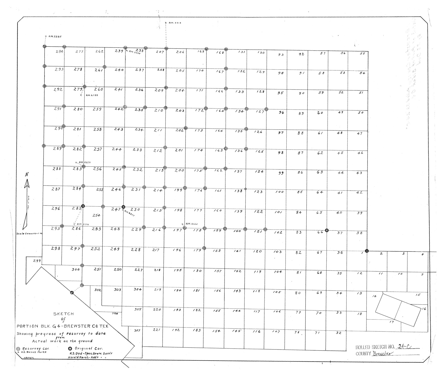
Sketch of portion Blk. G4 - Brewster Co., Tex. showing progress of resurvey to date from actual work on the ground
-
Map/Doc
5210
-
Collection
General Map Collection
-
People and Organizations
R.S. Dod (Surveyor/Engineer)
Harold Marsh (Surveyor/Engineer)
-
Counties
Brewster
-
Subjects
Surveying Rolled Sketch
-
Height x Width
17.5 x 20.8 inches
44.5 x 52.8 cm
-
Medium
linen, manuscript
-
Scale
1" = 2000 varas
-
Comments
See Brewster County Rolled Sketch 125 (43141) for surveyor’s report.
Related maps
Brewster County Rolled Sketch 125

Print $179.00
- Digital $50.00
Brewster County Rolled Sketch 125
1889
Map/Doc 43141
Part of: General Map Collection
Gaines County Sketch File 23

Print $20.00
- Digital $50.00
Gaines County Sketch File 23
1964
Size 20.0 x 22.8 inches
Map/Doc 11529
Survey Gulf to Beaumont and Orange, Texas

Print $20.00
- Digital $50.00
Survey Gulf to Beaumont and Orange, Texas
1929
Size 29.3 x 41.7 inches
Map/Doc 3089
Hall County Sketch File 7

Print $20.00
- Digital $50.00
Hall County Sketch File 7
1890
Size 12.0 x 22.4 inches
Map/Doc 11603


Flight Mission No. BQY-4M, Frame 38, Harris County

Print $20.00
- Digital $50.00
Flight Mission No. BQY-4M, Frame 38, Harris County
1953
Size 18.6 x 22.4 inches
Map/Doc 85253
Mason County Working Sketch 14

Print $20.00
- Digital $50.00
Mason County Working Sketch 14
1959
Size 28.6 x 23.3 inches
Map/Doc 70850
Culberson County Working Sketch 87

Print $20.00
- Digital $50.00
Culberson County Working Sketch 87
1981
Size 26.9 x 37.1 inches
Map/Doc 68541
La Salle County

Print $20.00
- Digital $50.00
La Salle County
1886
Size 25.4 x 21.3 inches
Map/Doc 3795
Val Verde County Rolled Sketch ECS

Print $20.00
- Digital $50.00
Val Verde County Rolled Sketch ECS
1935
Size 45.6 x 35.6 inches
Map/Doc 10079
El Paso County Boundary File 2

Print $28.00
- Digital $50.00
El Paso County Boundary File 2
Size 13.2 x 8.2 inches
Map/Doc 53021
Flight Mission No. DAG-17K, Frame 119, Matagorda County

Print $20.00
- Digital $50.00
Flight Mission No. DAG-17K, Frame 119, Matagorda County
1952
Size 16.4 x 16.5 inches
Map/Doc 86339
You may also like
Live Oak County Working Sketch 13

Print $20.00
- Digital $50.00
Live Oak County Working Sketch 13
1957
Size 42.1 x 38.7 inches
Map/Doc 70598
Erath County Working Sketch 33

Print $20.00
- Digital $50.00
Erath County Working Sketch 33
1972
Size 25.1 x 21.0 inches
Map/Doc 69114
The Republic County of Brazoria. January 20, 1841

Print $20.00
The Republic County of Brazoria. January 20, 1841
2020
Size 14.7 x 21.8 inches
Map/Doc 96114
Dimmit County Boundary File 6

Print $32.00
- Digital $50.00
Dimmit County Boundary File 6
Size 31.1 x 7.0 inches
Map/Doc 52580
Limestone County Sketch File 20

Print $44.00
- Digital $50.00
Limestone County Sketch File 20
1922
Size 11.2 x 8.5 inches
Map/Doc 30195
Hamilton County Rolled Sketch 14

Print $20.00
- Digital $50.00
Hamilton County Rolled Sketch 14
1989
Size 28.0 x 40.0 inches
Map/Doc 6063
Sulphur River, Turner Lake Sheet, Cuthand Creek

Print $20.00
- Digital $50.00
Sulphur River, Turner Lake Sheet, Cuthand Creek
1922
Size 17.5 x 18.3 inches
Map/Doc 78338
[WWI Topographic Planning Map of the Ardennes]
![94129, [WWI Topographic Planning Map of the Ardennes], Non-GLO Digital Images](https://historictexasmaps.com/wmedia_w700/maps/94129-1.tif.jpg)
Print $20.00
[WWI Topographic Planning Map of the Ardennes]
1918
Size 35.8 x 20.2 inches
Map/Doc 94129
Throckmorton County Boundary File 1

Print $12.00
- Digital $50.00
Throckmorton County Boundary File 1
Size 8.8 x 7.8 inches
Map/Doc 59258
Hockley County Sketch File 13

Print $4.00
- Digital $50.00
Hockley County Sketch File 13
1914
Size 8.9 x 10.9 inches
Map/Doc 26548
Map of part of Presidio Co. Texas

Print $20.00
- Digital $50.00
Map of part of Presidio Co. Texas
Size 16.5 x 21.3 inches
Map/Doc 75769
Map of Menard County, Texas

Print $20.00
- Digital $50.00
Map of Menard County, Texas
1879
Size 18.5 x 24.8 inches
Map/Doc 580