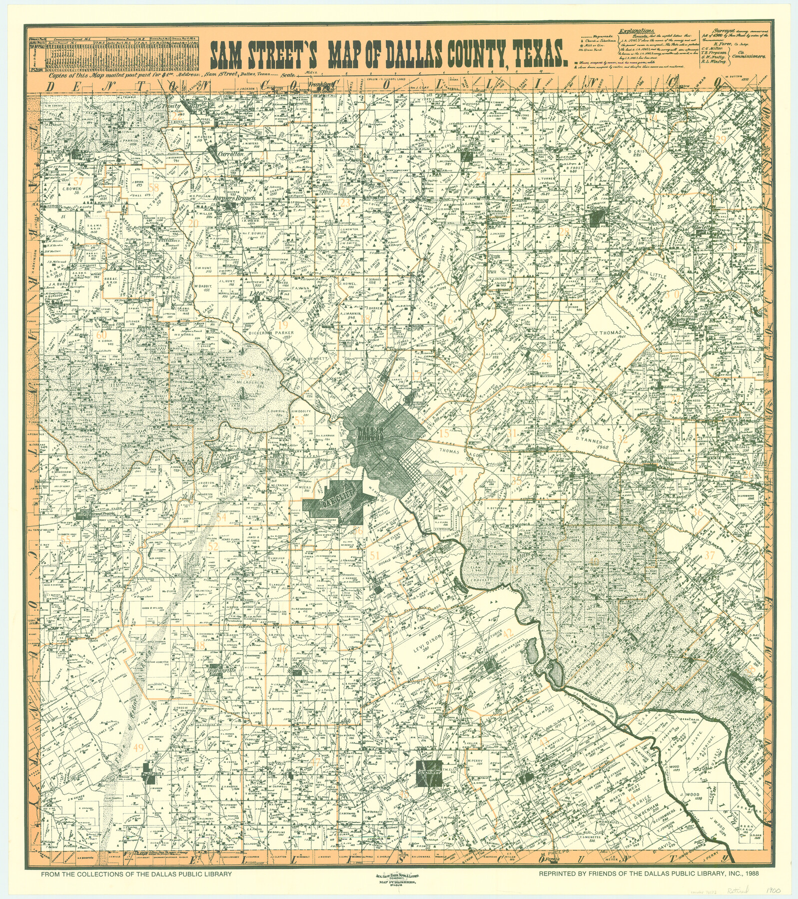
Sam Street's Map of Dallas County, Texas
-
Map/Doc
76173
-
Collection
General Map Collection
-
Object Dates
1900 (Creation Date)
-
People and Organizations
Sam Street, Dallas, Texas (Publisher)
August Gast Bank Note & Lithograph Company (Lithographer)
-
Counties
Dallas
-
Subjects
County
-
Height x Width
32.1 x 28.5 inches
81.5 x 72.4 cm
-
Comments
From the collections of the Dallas Public Library; reprinted 1988. Available for research only---for copies of this map please contact the Dallas Public Library.
-
Features
Cottonwood Creek
Vernoy Branch of Mountain Creek
Walnut Creek
Five Mile Post Office
Lisbon
Five Mile Creek
Rylie Post Office
TTRR
Elam
Oak Cliff
Mountain Creek
Duncanville
Mill House Lake
Grand Prairie
Bear Creek
Eagle Ford
Dallas
Oak Land Cemetery
White Rock Creek
Orphan Home
T&P
Wilmer
Frankford
Parson's Slough
Ferris
Desoto Post Office
Holland Branch of Trinity River
Face of Cedar Ridge
Cedar Hill
Ten Mile Creek
Fish Pond
Lancaster
Mesquite Creek
Goff Branch of Trinity River
Seagoville
Simonds
Kleberg
Dowdy's Club Lake
Fin and Feather Lake
Hutchins
MK&T
Wheatland
Rowlett Creek
Coppell
Trinity River
Elm Fork of Trinity River
West Fork of Trinity River
East Fork of Trinity River
Farmers Branch
Alpha Post Office
Audelia Post Office
Duck Creek
Hay Creek
Hackberry Creek
Rowlette [sic]
Garland
Muddy Creek
Pleasant Valley
GC&SF
Spring Creek
Richardson
Carralton [sic]
Trinity Mill
D&W
South Mesquite Creek
North Mesquite Creek
Mesquite
New Hope
Thomas' Ranch
Tuner's Place or Ranch
Sowers
Estella Post Office
Finley Post Office
Owen's Lake
SLS
Letot
Rollins Post Office
Calhoun
Reinhard
Housley Post Office
House Lake
Bois D'Arc Creek
Centreville
White Creek
Part of: General Map Collection
Texas Coordinate File 8

Print $4.00
- Digital $50.00
Texas Coordinate File 8
Size 11.3 x 8.7 inches
Map/Doc 75318
Reeves County Rolled Sketch 1

Print $40.00
- Digital $50.00
Reeves County Rolled Sketch 1
Size 52.9 x 38.5 inches
Map/Doc 9844
El Paso County Rolled Sketch 52

Print $20.00
- Digital $50.00
El Paso County Rolled Sketch 52
1929
Size 18.6 x 24.5 inches
Map/Doc 5846
Milam County Boundary File 6c

Print $2.00
- Digital $50.00
Milam County Boundary File 6c
Size 11.2 x 8.5 inches
Map/Doc 57250
Clay County Sketch File 19

Print $5.00
- Digital $50.00
Clay County Sketch File 19
Size 9.2 x 9.9 inches
Map/Doc 18429
Aransas County NRC Article 33.136 Location Key Sheet

Print $20.00
- Digital $50.00
Aransas County NRC Article 33.136 Location Key Sheet
1970
Size 27.0 x 23.0 inches
Map/Doc 87904
Harris County Rolled Sketch GC

Print $40.00
- Digital $50.00
Harris County Rolled Sketch GC
1917
Size 42.1 x 52.4 inches
Map/Doc 9115
Coast Chart No. 211 - Padre I. and Laguna Madre, Lat. 27° 12' to Lat. 26° 33', Texas

Print $20.00
- Digital $50.00
Coast Chart No. 211 - Padre I. and Laguna Madre, Lat. 27° 12' to Lat. 26° 33', Texas
1890
Size 41.0 x 33.4 inches
Map/Doc 73501
Map of Titus County

Print $20.00
- Digital $50.00
Map of Titus County
1857
Size 24.1 x 34.5 inches
Map/Doc 83380
Upton County Working Sketch 12

Print $40.00
- Digital $50.00
Upton County Working Sketch 12
1937
Size 43.6 x 77.9 inches
Map/Doc 69508
Chart of the West Indies and Spanish Dominions in North America

Print $20.00
- Digital $50.00
Chart of the West Indies and Spanish Dominions in North America
1803
Size 25.5 x 38.9 inches
Map/Doc 97139
Galveston County Rolled Sketch 30

Print $20.00
- Digital $50.00
Galveston County Rolled Sketch 30
1979
Size 28.0 x 39.8 inches
Map/Doc 5964
You may also like
Gulf Intracoastal Waterway - High Island to Chocolate Bay, Location of Spoil Disposal Areas

Print $20.00
- Digital $50.00
Gulf Intracoastal Waterway - High Island to Chocolate Bay, Location of Spoil Disposal Areas
1961
Size 31.1 x 40.8 inches
Map/Doc 61830
Smith County Rolled Sketch 6A2

Print $40.00
- Digital $50.00
Smith County Rolled Sketch 6A2
1934
Size 48.7 x 36.7 inches
Map/Doc 10702
Gillespie County Working Sketch 5

Print $20.00
- Digital $50.00
Gillespie County Working Sketch 5
1972
Size 25.7 x 25.9 inches
Map/Doc 63168
Galveston County NRC Article 33.136 Sketch 31

Print $22.00
- Digital $50.00
Galveston County NRC Article 33.136 Sketch 31
2005
Size 22.2 x 33.7 inches
Map/Doc 83280
Intracoastal Waterway in Texas - Corpus Christi to Point Isabel including Arroyo Colorado to Mo. Pac. R.R. Bridge Near Harlingen

Print $20.00
- Digital $50.00
Intracoastal Waterway in Texas - Corpus Christi to Point Isabel including Arroyo Colorado to Mo. Pac. R.R. Bridge Near Harlingen
1933
Size 27.5 x 40.6 inches
Map/Doc 61869
La Salle County Rolled Sketch 2

Print $20.00
- Digital $50.00
La Salle County Rolled Sketch 2
1915
Size 25.2 x 23.2 inches
Map/Doc 6567
General Highway Map, Hardeman County, Texas

Print $20.00
General Highway Map, Hardeman County, Texas
1940
Size 25.0 x 18.3 inches
Map/Doc 79113
Aransas County, Texas

Print $20.00
- Digital $50.00
Aransas County, Texas
1880
Size 19.3 x 20.2 inches
Map/Doc 665
Padre Island National Seashore

Print $4.00
- Digital $50.00
Padre Island National Seashore
Size 16.0 x 21.8 inches
Map/Doc 60527
Palo Pinto County Rolled Sketch 4

Print $20.00
- Digital $50.00
Palo Pinto County Rolled Sketch 4
Size 15.9 x 23.2 inches
Map/Doc 7189
Sketch of Robertson Co., Tehuacana Creek

Print $3.00
- Digital $50.00
Sketch of Robertson Co., Tehuacana Creek
1846
Size 10.3 x 16.4 inches
Map/Doc 264
Dallam County Boundary File 2

Print $18.00
- Digital $50.00
Dallam County Boundary File 2
Size 8.7 x 4.3 inches
Map/Doc 52053