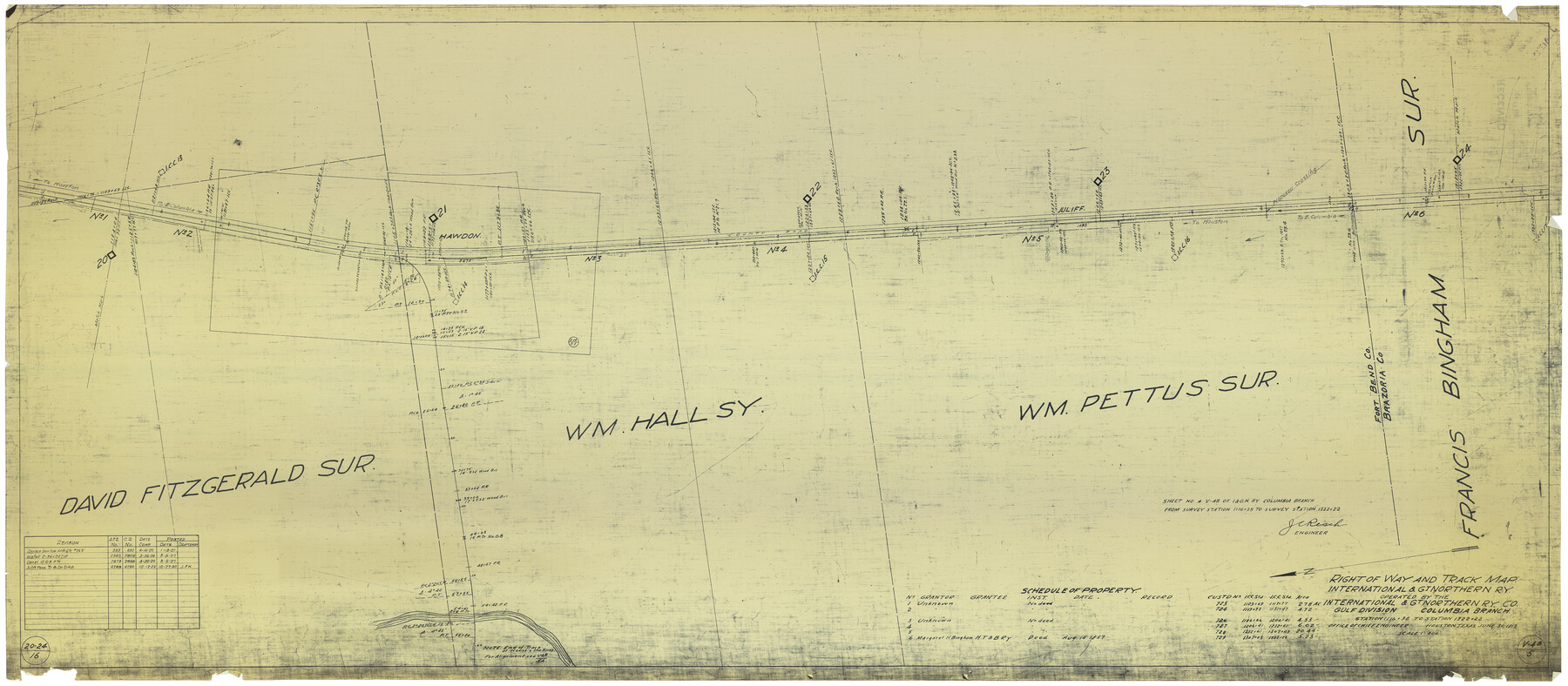
Right of Way and Track Map International & Gt. Northern Ry. operated by the International & Gt. Northern Ry. Co., Gulf Division, Columbia Branch
Station 1116+98 to Station 1322+22
Z-2-184
-
Map/Doc
64601
-
Collection
General Map Collection
-
Object Dates
6/30/1917 (Creation Date)
1/13/1921 (Revision Date)
3/5/1927 (Revision Date)
10/27/1930 (Revision Date)
-
People and Organizations
J. C. Resch (Surveyor/Engineer)
-
Counties
Brazoria Fort Bend
-
Subjects
Railroads
-
Height x Width
25.3 x 56.7 inches
64.3 x 144.0 cm
-
Medium
blueprint/diazo
-
Scale
1" = 400 feet
-
Comments
See counter nos. 64593 through 64600 for other sheets.
-
Features
I&GN
[Railroad line] to East Columbia
[Railroad line] to Houston
Hawdon
Part of: General Map Collection
Wharton County

Print $20.00
- Digital $50.00
Wharton County
1946
Size 41.4 x 46.9 inches
Map/Doc 77455
Gray County Rolled Sketch A

Print $20.00
- Digital $50.00
Gray County Rolled Sketch A
1888
Size 40.4 x 40.8 inches
Map/Doc 9008
Nueces County Rolled Sketch 51B

Print $20.00
- Digital $50.00
Nueces County Rolled Sketch 51B
Size 17.6 x 16.0 inches
Map/Doc 6891

[Sketch for Mineral Application 24072, San Jacinto River]
![65598, [Sketch for Mineral Application 24072, San Jacinto River], General Map Collection](https://historictexasmaps.com/wmedia_w700/maps/65598.tif.jpg)
Print $20.00
- Digital $50.00
[Sketch for Mineral Application 24072, San Jacinto River]
1929
Size 24.6 x 18.3 inches
Map/Doc 65598
Real County Rolled Sketch 9

Print $20.00
- Digital $50.00
Real County Rolled Sketch 9
1967
Size 33.4 x 40.6 inches
Map/Doc 9834
Crosby County Sketch File 3

Print $36.00
- Digital $50.00
Crosby County Sketch File 3
1885
Size 12.8 x 8.7 inches
Map/Doc 19992
Clay County Sketch File 16

Print $9.00
- Digital $50.00
Clay County Sketch File 16
1874
Size 8.3 x 7.9 inches
Map/Doc 18421
Clay County Sketch File 49

Print $78.00
- Digital $50.00
Clay County Sketch File 49
1928
Size 14.2 x 8.8 inches
Map/Doc 18500
Map of Wichita County Young Land District, formerly Fannin Land District

Print $20.00
- Digital $50.00
Map of Wichita County Young Land District, formerly Fannin Land District
1859
Size 22.4 x 20.5 inches
Map/Doc 4141
Cooke County Working Sketch 31

Print $20.00
- Digital $50.00
Cooke County Working Sketch 31
1980
Size 27.0 x 32.2 inches
Map/Doc 68268
Freestone County Working Sketch 22

Print $20.00
- Digital $50.00
Freestone County Working Sketch 22
1981
Size 35.5 x 32.3 inches
Map/Doc 69264
You may also like
![89829, [Central Yates], Twichell Survey Records](https://historictexasmaps.com/wmedia_w700/maps/89829-1.tif.jpg)
Denton County Working Sketch 26

Print $20.00
- Digital $50.00
Denton County Working Sketch 26
1995
Size 29.3 x 33.9 inches
Map/Doc 68631
Crockett County Sketch File 10

Print $20.00
- Digital $50.00
Crockett County Sketch File 10
Size 14.0 x 12.7 inches
Map/Doc 75924
Dickens County Sketch File L1

Print $16.00
- Digital $50.00
Dickens County Sketch File L1
1907
Size 9.1 x 7.4 inches
Map/Doc 20903
Kimble County Working Sketch 15

Print $20.00
- Digital $50.00
Kimble County Working Sketch 15
1923
Size 22.4 x 22.1 inches
Map/Doc 70083
Dallas County Working Sketch 2

Print $20.00
- Digital $50.00
Dallas County Working Sketch 2
1917
Size 18.2 x 19.0 inches
Map/Doc 68568
Ward County, 1902

Print $40.00
- Digital $50.00
Ward County, 1902
1902
Size 51.8 x 31.3 inches
Map/Doc 89650
Tom Green Co.

Print $40.00
- Digital $50.00
Tom Green Co.
1887
Size 42.0 x 110.7 inches
Map/Doc 76034
Map of the Fort Worth & Denver City Railway

Print $40.00
- Digital $50.00
Map of the Fort Worth & Denver City Railway
1887
Size 21.7 x 72.8 inches
Map/Doc 64479
From Citizens of Shelby County for the Creation of a New County to be Called Caddo, April 7, 1838

Print $20.00
From Citizens of Shelby County for the Creation of a New County to be Called Caddo, April 7, 1838
2020
Size 25.5 x 21.7 inches
Map/Doc 96377

Outer Continental Shelf Leasing Maps (Texas Offshore Operations)

Print $20.00
- Digital $50.00
Outer Continental Shelf Leasing Maps (Texas Offshore Operations)
1954
Size 11.6 x 12.3 inches
Map/Doc 75835