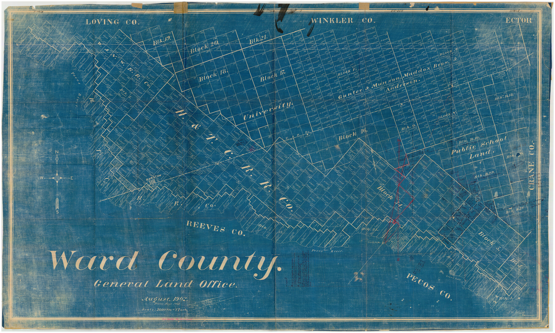
Ward County, 1902
238-28
-
Map/Doc
89650
-
Collection
Twichell Survey Records
-
Object Dates
8/1902 (Creation Date)
-
Counties
Ward
-
Subjects
County
-
Height x Width
51.8 x 31.3 inches
131.6 x 79.5 cm
Part of: Twichell Survey Records
[I. & G. N. Block 1]
![91592, [I. & G. N. Block 1], Twichell Survey Records](https://historictexasmaps.com/wmedia_w700/maps/91592-1.tif.jpg)
Print $20.00
- Digital $50.00
[I. & G. N. Block 1]
Size 17.2 x 18.1 inches
Map/Doc 91592
Kent County, 1898

Print $20.00
- Digital $50.00
Kent County, 1898
1898
Size 38.1 x 41.6 inches
Map/Doc 89706
[Part of Block GG and river sections 69-79]
![90470, [Part of Block GG and river sections 69-79], Twichell Survey Records](https://historictexasmaps.com/wmedia_w700/maps/90470-1.tif.jpg)
Print $20.00
- Digital $50.00
[Part of Block GG and river sections 69-79]
Size 43.2 x 31.2 inches
Map/Doc 90470
[Worksheets related to the Wilson Strickland survey and vicinity]
![91266, [Vicinity and related to the Wilson Strickland Survey], Twichell Survey Records](https://historictexasmaps.com/wmedia_w700/maps/91266-1.tif.jpg)
Print $20.00
- Digital $50.00
[Worksheets related to the Wilson Strickland survey and vicinity]
Size 35.8 x 17.5 inches
Map/Doc 91266
Hutchinson County

Print $20.00
- Digital $50.00
Hutchinson County
1922
Size 14.6 x 17.6 inches
Map/Doc 91183
Sketch in Castro County

Print $2.00
- Digital $50.00
Sketch in Castro County
1888
Size 7.8 x 7.9 inches
Map/Doc 90388
Laneer vs. Bivins, Potter County, Texas

Print $20.00
- Digital $50.00
Laneer vs. Bivins, Potter County, Texas
Size 21.7 x 19.0 inches
Map/Doc 93103
[West line of H. & T. C. RR. Block 97 and Blocks 29 and 30]
![90212, [West line of H. & T. C. RR. Block 97 and Blocks 29 and 30], Twichell Survey Records](https://historictexasmaps.com/wmedia_w700/maps/90212-1.tif.jpg)
Print $20.00
- Digital $50.00
[West line of H. & T. C. RR. Block 97 and Blocks 29 and 30]
Size 17.2 x 25.3 inches
Map/Doc 90212
[S.E. corner of Sec. 48, Blk. 35 T5N to N.E. corner of Sec. 1, Blk. 35 T5N]
![89826, [S.E. corner of Sec. 48, Blk. 35 T5N to N.E. corner of Sec. 1, Blk. 35 T5N], Twichell Survey Records](https://historictexasmaps.com/wmedia_w700/maps/89826-1.tif.jpg)
Print $40.00
- Digital $50.00
[S.E. corner of Sec. 48, Blk. 35 T5N to N.E. corner of Sec. 1, Blk. 35 T5N]
1907
Size 7.2 x 72.9 inches
Map/Doc 89826
University of Texas System University Lands

Print $20.00
- Digital $50.00
University of Texas System University Lands
1933
Size 23.0 x 17.7 inches
Map/Doc 93248
[Sketch showing Potter County Block 2] / [Sketch showing F. W. & D. C. Round House]
![91710, [Sketch showing Potter County Block 2] / [Sketch showing F. W. & D. C. Round House], Twichell Survey Records](https://historictexasmaps.com/wmedia_w700/maps/91710-1.tif.jpg)
Print $20.00
- Digital $50.00
[Sketch showing Potter County Block 2] / [Sketch showing F. W. & D. C. Round House]
Size 14.6 x 12.1 inches
Map/Doc 91710

You may also like
McMullen County Rolled Sketch 13

Print $20.00
- Digital $50.00
McMullen County Rolled Sketch 13
1943
Size 45.8 x 29.4 inches
Map/Doc 6730
Winkler County Rolled Sketch 10

Print $40.00
- Digital $50.00
Winkler County Rolled Sketch 10
1958
Size 29.4 x 55.9 inches
Map/Doc 10151
Val Verde County Rolled Sketch 54

Print $40.00
- Digital $50.00
Val Verde County Rolled Sketch 54
1938
Size 63.5 x 44.0 inches
Map/Doc 8123
Hale County Boundary File 1

Print $44.00
- Digital $50.00
Hale County Boundary File 1
Size 10.0 x 30.9 inches
Map/Doc 54031
Montague County

Print $20.00
- Digital $50.00
Montague County
1924
Size 46.9 x 33.7 inches
Map/Doc 73243
Nacogdoches County Working Sketch 9

Print $20.00
- Digital $50.00
Nacogdoches County Working Sketch 9
1967
Size 27.6 x 32.1 inches
Map/Doc 71225
Correct Map Lamb County (skeleton sketch)

Print $40.00
- Digital $50.00
Correct Map Lamb County (skeleton sketch)
Size 56.3 x 79.2 inches
Map/Doc 93140
Donley County Sketch File 7

Print $20.00
- Digital $50.00
Donley County Sketch File 7
Size 38.3 x 38.2 inches
Map/Doc 10367
Orange County NRC Article 33.136 Sketch 5

Print $62.00
- Digital $50.00
Orange County NRC Article 33.136 Sketch 5
2014
Size 26.1 x 22.7 inches
Map/Doc 94946
Fannin County Rolled Sketch 18B

Print $20.00
- Digital $50.00
Fannin County Rolled Sketch 18B
Size 12.7 x 16.1 inches
Map/Doc 5869
Map of Cottle County

Print $20.00
- Digital $50.00
Map of Cottle County
1893
Size 23.1 x 19.4 inches
Map/Doc 3451
A new and complete county map of all the rail roads in the United States & Canadas in operation & progress.

Print $20.00
A new and complete county map of all the rail roads in the United States & Canadas in operation & progress.
1857
Size 19.3 x 22.0 inches
Map/Doc 93606