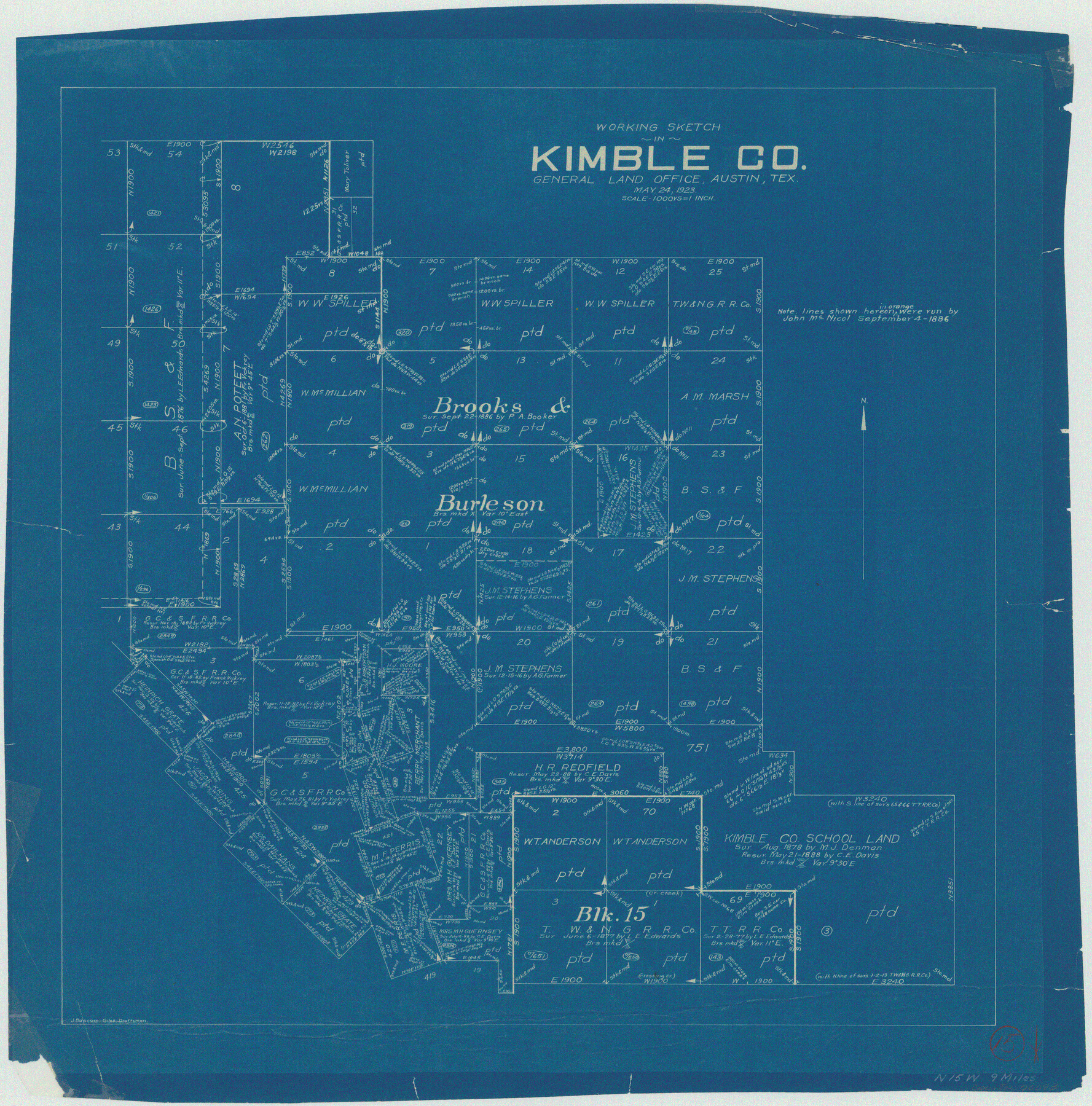
Kimble County Working Sketch 15
-
Map/Doc
70083
-
Collection
General Map Collection
-
Object Dates
5/24/1923 (Creation Date)
-
People and Organizations
J. Bascom Giles (Draftsman)
-
Counties
Kimble
-
Subjects
Surveying Working Sketch
-
Height x Width
22.4 x 22.1 inches
56.9 x 56.1 cm
-
Scale
1" = 1000 varas
Part of: General Map Collection
South Montgomery County, Woodlands Chamber of Commerce Street Map

South Montgomery County, Woodlands Chamber of Commerce Street Map
Size 50.0 x 37.8 inches
Map/Doc 94364
Flight Mission No. BRA-9M, Frame 64, Jefferson County

Print $20.00
- Digital $50.00
Flight Mission No. BRA-9M, Frame 64, Jefferson County
1953
Size 18.6 x 22.4 inches
Map/Doc 85647
Red River, Bois D'Arc Creek Floodway Sheet No. 6

Print $20.00
- Digital $50.00
Red River, Bois D'Arc Creek Floodway Sheet No. 6
1917
Size 28.9 x 23.4 inches
Map/Doc 69661
Polk County Working Sketch 11

Print $20.00
- Digital $50.00
Polk County Working Sketch 11
1940
Size 29.3 x 28.6 inches
Map/Doc 71626
Flight Mission No. BRA-8M, Frame 113, Jefferson County

Print $20.00
- Digital $50.00
Flight Mission No. BRA-8M, Frame 113, Jefferson County
1953
Size 18.6 x 22.3 inches
Map/Doc 85609
Motley County Sketch File 5 (S)

Print $20.00
- Digital $50.00
Motley County Sketch File 5 (S)
Size 20.5 x 19.4 inches
Map/Doc 42138
Upton County Sketch File 14a

Print $18.00
- Digital $50.00
Upton County Sketch File 14a
1927
Size 14.5 x 9.1 inches
Map/Doc 38864
Houston County Working Sketch 30

Print $20.00
- Digital $50.00
Houston County Working Sketch 30
1990
Size 36.9 x 37.0 inches
Map/Doc 66260
San Jacinto County Working Sketch 22

Print $20.00
- Digital $50.00
San Jacinto County Working Sketch 22
1940
Size 21.3 x 25.3 inches
Map/Doc 63735
Brewster County Rolled Sketch 6

Print $40.00
- Digital $50.00
Brewster County Rolled Sketch 6
Size 43.0 x 66.2 inches
Map/Doc 75944
Flight Mission No. CRC-3R, Frame 22, Chambers County

Print $20.00
- Digital $50.00
Flight Mission No. CRC-3R, Frame 22, Chambers County
1956
Size 18.6 x 22.3 inches
Map/Doc 84796
Webb County Rolled Sketch 60

Print $20.00
- Digital $50.00
Webb County Rolled Sketch 60
1947
Size 30.0 x 33.8 inches
Map/Doc 8211
You may also like
Beaumont, Texas

Print $20.00
- Digital $50.00
Beaumont, Texas
1930
Size 10.3 x 32.7 inches
Map/Doc 96428
Webb County Working Sketch 16

Print $20.00
- Digital $50.00
Webb County Working Sketch 16
1923
Size 27.6 x 32.1 inches
Map/Doc 72381
Abstract of Land Titles in the Spanish Department of the General Land Office of the State of Texas - 1824-36

Abstract of Land Titles in the Spanish Department of the General Land Office of the State of Texas - 1824-36
1857
Size 17.6 x 11.9 inches
Map/Doc 94535
Texas Gulf Coast from Sabine River to the Rio Grande

Print $20.00
- Digital $50.00
Texas Gulf Coast from Sabine River to the Rio Grande
1953
Size 45.9 x 43.6 inches
Map/Doc 2945
Flight Mission No. CLL-3N, Frame 41, Willacy County

Print $20.00
- Digital $50.00
Flight Mission No. CLL-3N, Frame 41, Willacy County
1954
Size 18.4 x 22.1 inches
Map/Doc 87099
Morris County Rolled Sketch 2A

Print $20.00
- Digital $50.00
Morris County Rolled Sketch 2A
Size 24.0 x 18.7 inches
Map/Doc 10272
Dimmit County Boundary File 3

Print $12.00
- Digital $50.00
Dimmit County Boundary File 3
Size 14.4 x 8.9 inches
Map/Doc 52566
Flight Mission No. DIX-10P, Frame 65, Aransas County

Print $20.00
- Digital $50.00
Flight Mission No. DIX-10P, Frame 65, Aransas County
1956
Size 18.6 x 22.3 inches
Map/Doc 83926
Anton Independent School District Hockley and Lamb Counties, Texas

Print $20.00
- Digital $50.00
Anton Independent School District Hockley and Lamb Counties, Texas
Size 19.3 x 23.7 inches
Map/Doc 92215
Navigation Maps of Gulf Intracoastal Waterway, Port Arthur to Brownsville, Texas

Print $4.00
- Digital $50.00
Navigation Maps of Gulf Intracoastal Waterway, Port Arthur to Brownsville, Texas
1951
Size 16.7 x 21.2 inches
Map/Doc 65449
Falls County Sketch File 21a

Print $54.00
- Digital $50.00
Falls County Sketch File 21a
1869
Size 13.0 x 8.2 inches
Map/Doc 22396
Map of Travis County

Print $20.00
- Digital $50.00
Map of Travis County
1861
Size 21.2 x 25.3 inches
Map/Doc 4087