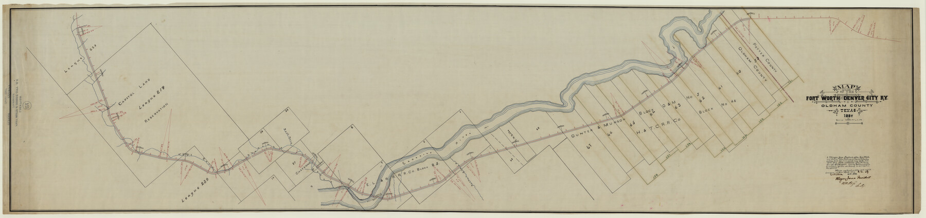
Map of the Fort Worth & Denver City Railway, Oldham County, Texas
Z-2-124
-
Map/Doc
64456
-
Collection
General Map Collection
-
Object Dates
1887 (Creation Date)
-
Counties
Oldham
-
Subjects
Railroads
-
Height x Width
24.8 x 105.2 inches
63.0 x 267.2 cm
-
Medium
paper, manuscript
-
Scale
1000 ft = 1 in
-
Features
FW&DC
West Fork of Cheyenne Creek
East Fork of Cheyenne Creek
Canadian River
Parker Creek
Part of: General Map Collection
Newton County Rolled Sketch 6A

Digital $50.00
Newton County Rolled Sketch 6A
Size 10.3 x 15.4 inches
Map/Doc 46838
Morris County Rolled Sketch 2A

Print $20.00
- Digital $50.00
Morris County Rolled Sketch 2A
Size 24.0 x 18.8 inches
Map/Doc 10254
Harbor Pass and Bar at Brazos Santiago, Texas

Print $20.00
- Digital $50.00
Harbor Pass and Bar at Brazos Santiago, Texas
1871
Size 18.4 x 27.4 inches
Map/Doc 73039
Upshur County Working Sketch 1

Print $20.00
- Digital $50.00
Upshur County Working Sketch 1
1934
Size 28.9 x 32.6 inches
Map/Doc 69557
Dickens County Sketch File 9

Print $4.00
- Digital $50.00
Dickens County Sketch File 9
Size 21.6 x 20.9 inches
Map/Doc 11319
Flight Mission No. BRA-7M, Frame 141, Jefferson County

Print $20.00
- Digital $50.00
Flight Mission No. BRA-7M, Frame 141, Jefferson County
1953
Size 18.6 x 22.4 inches
Map/Doc 85535
Liberty County Working Sketch 26

Print $20.00
- Digital $50.00
Liberty County Working Sketch 26
1941
Size 29.8 x 26.4 inches
Map/Doc 70485
Upton County Working Sketch 14

Print $20.00
- Digital $50.00
Upton County Working Sketch 14
1938
Size 14.9 x 20.9 inches
Map/Doc 69510
Wise County Working Sketch 14

Print $20.00
- Digital $50.00
Wise County Working Sketch 14
1977
Size 19.0 x 18.0 inches
Map/Doc 72628
Flight Mission No. BRA-9M, Frame 76, Jefferson County

Print $20.00
- Digital $50.00
Flight Mission No. BRA-9M, Frame 76, Jefferson County
1953
Size 18.5 x 22.5 inches
Map/Doc 85659
Flight Mission No. DAG-24K, Frame 36, Matagorda County

Print $20.00
- Digital $50.00
Flight Mission No. DAG-24K, Frame 36, Matagorda County
1953
Size 18.5 x 22.2 inches
Map/Doc 86523
Flight Mission No. DQO-8K, Frame 86, Galveston County

Print $20.00
- Digital $50.00
Flight Mission No. DQO-8K, Frame 86, Galveston County
1952
Size 18.4 x 22.3 inches
Map/Doc 85188
You may also like
Guadalupe County Sketch File 7c

Print $22.00
- Digital $50.00
Guadalupe County Sketch File 7c
Size 12.7 x 15.5 inches
Map/Doc 24672
[Surveys in the Travis District along the Colorado and Pedernales Rivers]
![113, [Surveys in the Travis District along the Colorado and Pedernales Rivers], General Map Collection](https://historictexasmaps.com/wmedia_w700/maps/113.tif.jpg)
Print $2.00
- Digital $50.00
[Surveys in the Travis District along the Colorado and Pedernales Rivers]
1841
Size 9.9 x 8.2 inches
Map/Doc 113
Colorado County Sketch File 23

Print $4.00
- Digital $50.00
Colorado County Sketch File 23
1882
Size 8.8 x 8.3 inches
Map/Doc 18961


Coke County Working Sketch 16

Print $20.00
- Digital $50.00
Coke County Working Sketch 16
1948
Size 23.4 x 24.5 inches
Map/Doc 68053
San Jacinto County Working Sketch 25

Print $20.00
- Digital $50.00
San Jacinto County Working Sketch 25
1943
Size 34.4 x 34.2 inches
Map/Doc 63738
Tyler County Sketch File 30

Print $4.00
- Digital $50.00
Tyler County Sketch File 30
1989
Size 14.3 x 8.8 inches
Map/Doc 38721
Flight Mission No. DIX-8P, Frame 62, Aransas County

Print $20.00
- Digital $50.00
Flight Mission No. DIX-8P, Frame 62, Aransas County
1956
Size 18.5 x 22.2 inches
Map/Doc 83893
Copy of Surveyor's Field Book, Morris Browning - In Blocks 7, 5 & 4, I&GNRRCo., Hutchinson and Carson Counties, Texas

Print $2.00
- Digital $50.00
Copy of Surveyor's Field Book, Morris Browning - In Blocks 7, 5 & 4, I&GNRRCo., Hutchinson and Carson Counties, Texas
1888
Size 6.9 x 8.8 inches
Map/Doc 62260
Live Oak County Rolled Sketch 4

Print $20.00
- Digital $50.00
Live Oak County Rolled Sketch 4
1946
Size 27.7 x 32.1 inches
Map/Doc 6633
Duval County Rolled Sketch Pressly No. 2

Print $20.00
- Digital $50.00
Duval County Rolled Sketch Pressly No. 2
1935
Size 22.6 x 33.7 inches
Map/Doc 5770