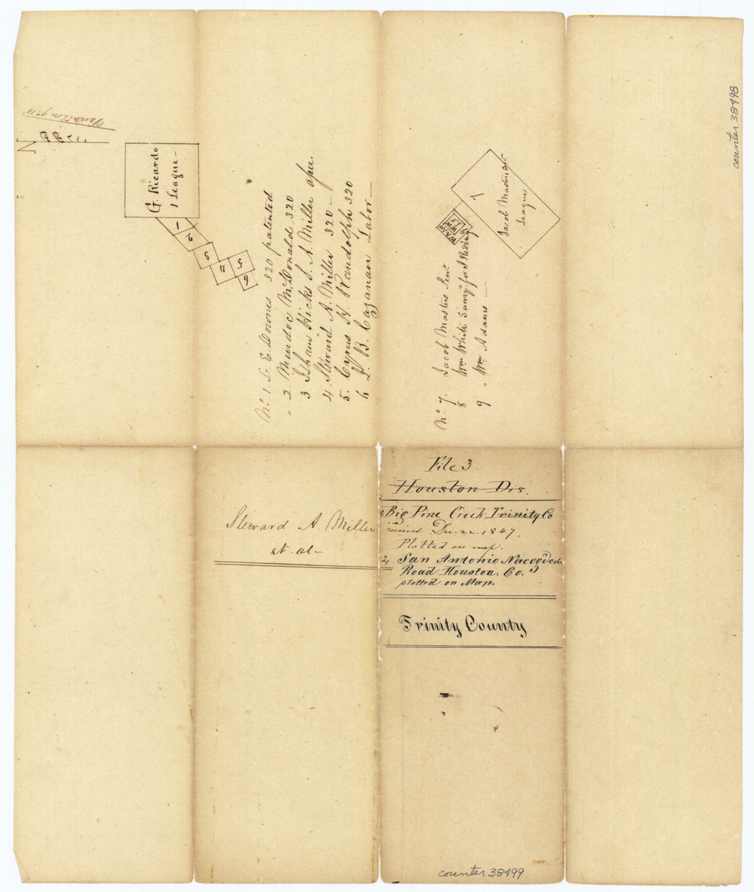
Trinity County Sketch File 3
[Sketches of G. Ricardo league and Jacob Masters Sr. league]
-
Map/Doc
38498
-
Collection
General Map Collection
-
Object Dates
12/22/1847 (File Date)
-
People and Organizations
W.M. James (Surveyor/Engineer)
-
Counties
Trinity
-
Subjects
Surveying Sketch File
-
Height x Width
12.6 x 15.0 inches
32.0 x 38.1 cm
-
Medium
paper, manuscript
-
Features
Big Pine Creek
San Antonio-Nacogdoches Road
Part of: General Map Collection
Tyler County Boundary File 89

Print $28.00
- Digital $50.00
Tyler County Boundary File 89
Size 9.2 x 7.2 inches
Map/Doc 59495
Kerr County Rolled Sketch 25

Print $20.00
- Digital $50.00
Kerr County Rolled Sketch 25
Size 24.7 x 31.0 inches
Map/Doc 6505

Pecos County Working Sketch 108

Print $40.00
- Digital $50.00
Pecos County Working Sketch 108
1971
Size 43.5 x 56.3 inches
Map/Doc 71581
Sterling County Working Sketch 3

Print $40.00
- Digital $50.00
Sterling County Working Sketch 3
1948
Size 43.6 x 55.2 inches
Map/Doc 63985
Hudspeth County Sketch File 27

Print $5.00
- Digital $50.00
Hudspeth County Sketch File 27
1941
Size 9.3 x 14.3 inches
Map/Doc 26984
Haskell County Sketch File 21

Print $20.00
- Digital $50.00
Haskell County Sketch File 21
1935
Size 30.2 x 20.3 inches
Map/Doc 11744
Hutchinson County Sketch File 27

Print $20.00
- Digital $50.00
Hutchinson County Sketch File 27
Size 21.0 x 24.9 inches
Map/Doc 11817
Nueces County Sketch File 19

Print $4.00
- Digital $50.00
Nueces County Sketch File 19
1875
Size 10.5 x 8.4 inches
Map/Doc 32551

Runnels County Sketch File 41

Print $20.00
Runnels County Sketch File 41
1892
Size 22.8 x 25.7 inches
Map/Doc 12271
Somervell County

Print $20.00
- Digital $50.00
Somervell County
1884
Size 29.5 x 31.3 inches
Map/Doc 63041
You may also like
Deaf Smith County

Print $20.00
- Digital $50.00
Deaf Smith County
1926
Size 32.9 x 41.3 inches
Map/Doc 77260
The United States

Print $20.00
- Digital $50.00
The United States
1907
Size 21.1 x 28.3 inches
Map/Doc 95859
Flight Mission No. DQO-3K, Frame 32, Galveston County

Print $20.00
- Digital $50.00
Flight Mission No. DQO-3K, Frame 32, Galveston County
1952
Size 18.7 x 22.5 inches
Map/Doc 85073

Jeff Davis County Working Sketch 28

Print $20.00
- Digital $50.00
Jeff Davis County Working Sketch 28
1967
Size 21.2 x 28.6 inches
Map/Doc 66523
Sutton County Rolled Sketch 56

Print $20.00
- Digital $50.00
Sutton County Rolled Sketch 56
Size 23.6 x 28.0 inches
Map/Doc 7895
Lamb County, Texas Compiled by Sylvan Sanders Lubbock, Texas

Print $20.00
- Digital $50.00
Lamb County, Texas Compiled by Sylvan Sanders Lubbock, Texas
Size 24.0 x 27.2 inches
Map/Doc 92200
Webb County Working Sketch 78

Print $20.00
- Digital $50.00
Webb County Working Sketch 78
1977
Size 35.0 x 42.1 inches
Map/Doc 72445
Shackelford County Working Sketch 13

Print $20.00
- Digital $50.00
Shackelford County Working Sketch 13
1999
Size 18.6 x 16.2 inches
Map/Doc 63853
Amistad International Reservoir on Rio Grande 84

Print $20.00
- Digital $50.00
Amistad International Reservoir on Rio Grande 84
1949
Size 28.4 x 40.2 inches
Map/Doc 75513
Montgomery County Boundary File 2

Print $6.00
- Digital $50.00
Montgomery County Boundary File 2
Size 17.1 x 11.4 inches
Map/Doc 57448
Navarro County Working Sketch 11

Print $40.00
- Digital $50.00
Navarro County Working Sketch 11
1978
Size 53.7 x 44.4 inches
Map/Doc 71241