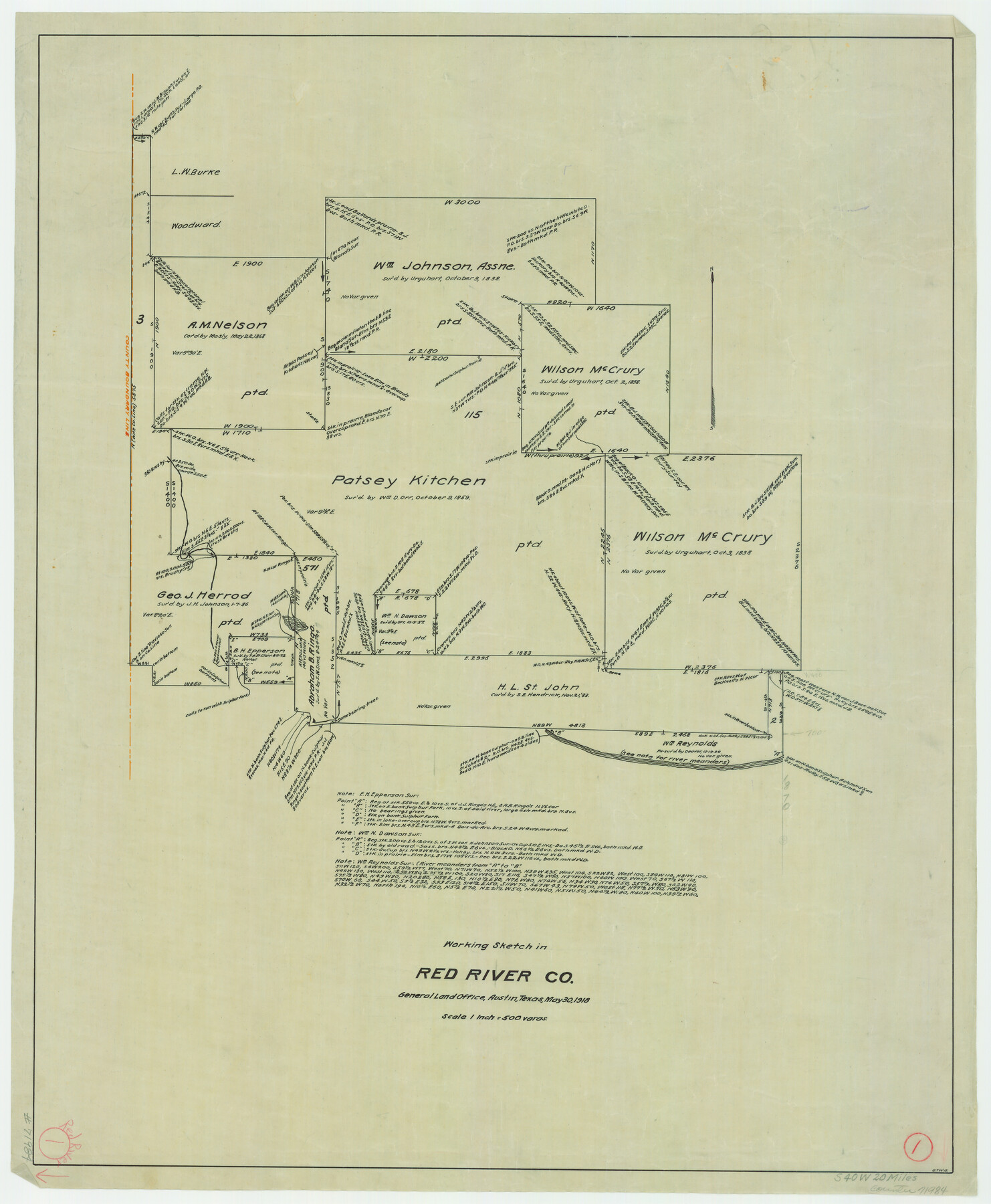
Red River County Working Sketch 1
-
Map/Doc
71984
-
Collection
General Map Collection
-
Object Dates
5/30/1918 (Creation Date)
-
People and Organizations
G.T. Wicker (Draftsman)
-
Counties
Red River
-
Subjects
Surveying Working Sketch
-
Height x Width
26.8 x 22.1 inches
68.1 x 56.1 cm
-
Scale
1" = 500 varas
Part of: General Map Collection
Williamson County Rolled Sketch 5

Print $20.00
- Digital $50.00
Williamson County Rolled Sketch 5
1940
Size 23.7 x 34.5 inches
Map/Doc 8263
Stephens County Sketch File 24

Print $5.00
- Digital $50.00
Stephens County Sketch File 24
1952
Size 24.5 x 32.5 inches
Map/Doc 12354
Trinity River, Carl Switch Sheet/Chambers Creek

Print $20.00
- Digital $50.00
Trinity River, Carl Switch Sheet/Chambers Creek
1930
Size 39.2 x 37.8 inches
Map/Doc 65216
Flight Mission No. DQO-7K, Frame 112, Galveston County

Print $20.00
- Digital $50.00
Flight Mission No. DQO-7K, Frame 112, Galveston County
1952
Size 18.9 x 22.4 inches
Map/Doc 85127

Flight Mission No. DAG-24K, Frame 141, Matagorda County

Print $20.00
- Digital $50.00
Flight Mission No. DAG-24K, Frame 141, Matagorda County
1953
Size 18.5 x 22.4 inches
Map/Doc 86559
Aransas County Sketch File 22

Print $34.00
- Digital $50.00
Aransas County Sketch File 22
1910
Size 14.8 x 9.1 inches
Map/Doc 13166
Angelina County Sketch File 19

Print $22.00
- Digital $50.00
Angelina County Sketch File 19
1876
Size 8.2 x 12.6 inches
Map/Doc 13036
Johnson County Working Sketch 21

Print $20.00
- Digital $50.00
Johnson County Working Sketch 21
1995
Size 18.1 x 29.6 inches
Map/Doc 66634
Bowie County Sketch File 6b

Print $40.00
- Digital $50.00
Bowie County Sketch File 6b
Size 14.4 x 13.5 inches
Map/Doc 14848
Flight Mission No. CLL-1N, Frame 31, Willacy County

Print $20.00
- Digital $50.00
Flight Mission No. CLL-1N, Frame 31, Willacy County
1954
Size 18.5 x 22.2 inches
Map/Doc 87012
Flight Mission No. DAG-24K, Frame 45, Matagorda County

Print $20.00
- Digital $50.00
Flight Mission No. DAG-24K, Frame 45, Matagorda County
1953
Size 18.6 x 22.2 inches
Map/Doc 86532
You may also like
Flight Mission No. CGI-2N, Frame 185, Cameron County

Print $20.00
- Digital $50.00
Flight Mission No. CGI-2N, Frame 185, Cameron County
1954
Size 18.5 x 22.2 inches
Map/Doc 84545
Motley County Sketch File F (S)

Print $14.00
- Digital $50.00
Motley County Sketch File F (S)
1904
Size 9.1 x 5.9 inches
Map/Doc 32179
Atascosa County Rolled Sketch 22

Print $40.00
- Digital $50.00
Atascosa County Rolled Sketch 22
1917
Size 57.5 x 26.5 inches
Map/Doc 8921
Wichita County Rolled Sketch 14A

Print $40.00
- Digital $50.00
Wichita County Rolled Sketch 14A
Size 28.0 x 59.9 inches
Map/Doc 10138
San Jacinto County Sketch File 4

Print $4.00
San Jacinto County Sketch File 4
1857
Size 12.9 x 7.9 inches
Map/Doc 35700
[Surveys along Bray's Bayou]
![157, [Surveys along Bray's Bayou], General Map Collection](https://historictexasmaps.com/wmedia_w700/maps/157.tif.jpg)
Print $2.00
- Digital $50.00
[Surveys along Bray's Bayou]
Size 7.6 x 4.9 inches
Map/Doc 157
Uvalde County Working Sketch 50

Print $40.00
- Digital $50.00
Uvalde County Working Sketch 50
1980
Size 55.7 x 36.6 inches
Map/Doc 72120
Map of Menard County

Print $20.00
- Digital $50.00
Map of Menard County
1871
Size 18.2 x 21.6 inches
Map/Doc 3873
Flight Mission No. CUG-1P, Frame 84, Kleberg County

Print $20.00
- Digital $50.00
Flight Mission No. CUG-1P, Frame 84, Kleberg County
1956
Size 18.4 x 22.3 inches
Map/Doc 86149
Map of Victoria County

Print $20.00
- Digital $50.00
Map of Victoria County
1895
Size 28.7 x 27.0 inches
Map/Doc 4117
Young County Working Sketch 9

Print $20.00
- Digital $50.00
Young County Working Sketch 9
1921
Size 25.9 x 36.6 inches
Map/Doc 62032
Uvalde County Working Sketch 42

Print $20.00
- Digital $50.00
Uvalde County Working Sketch 42
1978
Size 34.5 x 27.9 inches
Map/Doc 72112