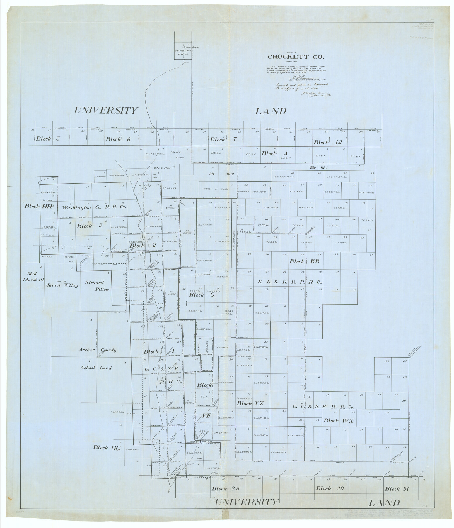
Crockett County Rolled Sketch 31
Sketch in Crockett Co.
-
Map/Doc
8716
-
Collection
General Map Collection
-
Object Dates
1934 (Survey Date)
1934/6/7 (File Date)
-
People and Organizations
C.E. Grimmer (Surveyor/Engineer)
-
Counties
Crockett
-
Subjects
Surveying Rolled Sketch
-
Height x Width
58.1 x 50.0 inches
147.6 x 127.0 cm
-
Medium
linen, manuscript
-
Scale
1" = 1000 varas
Part of: General Map Collection
Current Miscellaneous File 111

Print $8.00
- Digital $50.00
Current Miscellaneous File 111
1996
Size 11.3 x 8.7 inches
Map/Doc 74714
Webb County Rolled Sketch 68

Print $43.00
- Digital $50.00
Webb County Rolled Sketch 68
1910
Size 9.6 x 15.1 inches
Map/Doc 49485
Upton County Working Sketch 14

Print $20.00
- Digital $50.00
Upton County Working Sketch 14
1938
Size 14.9 x 20.9 inches
Map/Doc 69510
Henderson County Sketch File 9

Print $8.00
- Digital $50.00
Henderson County Sketch File 9
Size 8.3 x 7.8 inches
Map/Doc 26343
Tyler County Working Sketch 8

Print $20.00
- Digital $50.00
Tyler County Working Sketch 8
1937
Size 31.0 x 34.9 inches
Map/Doc 69478
Flight Mission No. BRA-16M, Frame 92, Jefferson County

Print $20.00
- Digital $50.00
Flight Mission No. BRA-16M, Frame 92, Jefferson County
1953
Size 18.6 x 22.3 inches
Map/Doc 85704
Jones County Sketch File 6

Print $2.00
- Digital $50.00
Jones County Sketch File 6
1873
Size 8.3 x 11.8 inches
Map/Doc 28494
Presidio County Rolled Sketch 71

Print $20.00
- Digital $50.00
Presidio County Rolled Sketch 71
1941
Size 31.7 x 42.9 inches
Map/Doc 7361
Castro County Sketch File 4

Print $6.00
- Digital $50.00
Castro County Sketch File 4
1908
Size 6.9 x 8.9 inches
Map/Doc 17462
Irion County Boundary File 3a

Print $2.00
- Digital $50.00
Irion County Boundary File 3a
Size 12.9 x 8.3 inches
Map/Doc 55349
Stonewall County Sketch File 18

Print $16.00
- Digital $50.00
Stonewall County Sketch File 18
1902
Size 13.7 x 8.4 inches
Map/Doc 37276
Pecos County Rolled Sketch 138

Print $20.00
- Digital $50.00
Pecos County Rolled Sketch 138
Size 27.9 x 21.7 inches
Map/Doc 7274
You may also like
Brewster County Rolled Sketch 134

Print $20.00
- Digital $50.00
Brewster County Rolled Sketch 134
Size 19.0 x 24.9 inches
Map/Doc 5303
Van Zandt County Sketch File A45

Print $40.00
- Digital $50.00
Van Zandt County Sketch File A45
Size 14.2 x 13.7 inches
Map/Doc 39501
Young Territory

Print $20.00
- Digital $50.00
Young Territory
1874
Size 29.4 x 29.2 inches
Map/Doc 1977
Pecos County Rolled Sketch 141

Print $40.00
- Digital $50.00
Pecos County Rolled Sketch 141
1927
Size 60.5 x 20.4 inches
Map/Doc 10722
Map of the country adjacent to the left bank of the Rio Grande below Matamoros

Print $20.00
- Digital $50.00
Map of the country adjacent to the left bank of the Rio Grande below Matamoros
1847
Size 18.3 x 28.1 inches
Map/Doc 72872
Refugio County Sketch File 9

Print $4.00
- Digital $50.00
Refugio County Sketch File 9
1850
Size 5.5 x 7.6 inches
Map/Doc 35256
Concho County Rolled Sketch 14

Print $20.00
- Digital $50.00
Concho County Rolled Sketch 14
1959
Size 29.9 x 31.2 inches
Map/Doc 8659
General Highway Map, Webb County, Texas

Print $20.00
General Highway Map, Webb County, Texas
1961
Size 18.2 x 24.8 inches
Map/Doc 79704
Cochran County

Print $20.00
- Digital $50.00
Cochran County
1913
Size 29.1 x 20.0 inches
Map/Doc 4743
Right of Way and Track Map, the Missouri, Kansas and Texas Ry. of Texas - Henrietta Division

Print $20.00
- Digital $50.00
Right of Way and Track Map, the Missouri, Kansas and Texas Ry. of Texas - Henrietta Division
1918
Size 11.8 x 26.9 inches
Map/Doc 64754
The Judicial District/County of Burnet. Boundaries Redefined, December 6, 1841

Print $20.00
The Judicial District/County of Burnet. Boundaries Redefined, December 6, 1841
2020
Size 19.2 x 21.6 inches
Map/Doc 96323
