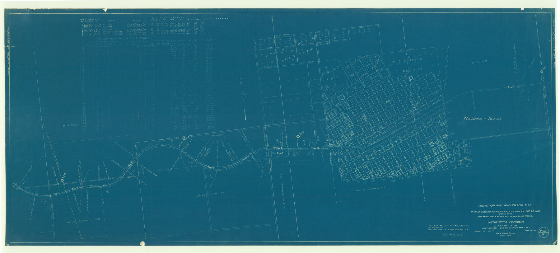
Right of Way and Track Map, The Missouri, Kansas and Texas Ry. of Texas operated by the Missouri, Kansas and Texas Ry. of Texas, Henrietta Division
M.P. 741 to M.P. 745, Station 4484+20.0 to Station 4714+96.0
Z-2-20
-
Map/Doc
64070
-
Collection
General Map Collection
-
Object Dates
1918/6/30 (Creation Date)
-
People and Organizations
Office of Valuation Committee (Publisher)
-
Counties
Montague
-
Subjects
Railroads
-
Height x Width
25.5 x 56.6 inches
64.8 x 143.8 cm
-
Medium
blueprint/diazo
-
Scale
1" = 400 feet
-
Comments
See 64065-64069 and 64071-64074 for other segments of the map. See 64064 (PDF) for the documents/letter that accompanied the map.
-
Features
MK&T
[Route] to Wichita Falls
Nocona
Part of: General Map Collection
Floyd County Boundary File 1a

Print $40.00
- Digital $50.00
Floyd County Boundary File 1a
Size 9.2 x 37.4 inches
Map/Doc 53460
Goliad County Working Sketch 2

Print $20.00
- Digital $50.00
Goliad County Working Sketch 2
1916
Size 15.5 x 21.6 inches
Map/Doc 63192
Flight Mission No. DQN-5K, Frame 75, Calhoun County

Print $20.00
- Digital $50.00
Flight Mission No. DQN-5K, Frame 75, Calhoun County
1953
Size 18.4 x 22.1 inches
Map/Doc 84408
McMullen County Sketch File 10

Print $40.00
- Digital $50.00
McMullen County Sketch File 10
1876
Size 14.3 x 17.6 inches
Map/Doc 31353
Jefferson County Boundary File 1

Print $10.00
- Digital $50.00
Jefferson County Boundary File 1
Size 9.8 x 6.7 inches
Map/Doc 55514
Burnet County Sketch File 10

Print $4.00
- Digital $50.00
Burnet County Sketch File 10
1848
Size 12.8 x 8.4 inches
Map/Doc 16690
Runnels County Boundary File 1b

Print $24.00
- Digital $50.00
Runnels County Boundary File 1b
Size 15.7 x 8.3 inches
Map/Doc 58514
Copy of Surveyor's Field Book, Morris Browning - In Blocks 7, 5 & 4, I&GNRRCo., Hutchinson and Carson Counties, Texas

Print $2.00
- Digital $50.00
Copy of Surveyor's Field Book, Morris Browning - In Blocks 7, 5 & 4, I&GNRRCo., Hutchinson and Carson Counties, Texas
1888
Size 6.9 x 8.8 inches
Map/Doc 62282

Gillespie County Rolled Sketch 3

Print $20.00
- Digital $50.00
Gillespie County Rolled Sketch 3
Size 19.0 x 28.1 inches
Map/Doc 6010
Navasota River, Long Bridge Crossing Sheet

Print $20.00
- Digital $50.00
Navasota River, Long Bridge Crossing Sheet
1934
Size 43.1 x 36.6 inches
Map/Doc 65073

You may also like
Township 4 South Ranges 12 and 13 West, South Western District, Louisiana

Print $20.00
- Digital $50.00
Township 4 South Ranges 12 and 13 West, South Western District, Louisiana
1879
Size 19.6 x 24.7 inches
Map/Doc 65884
Hoffman & Walker's Pictorial, Historical Map of Texas

Hoffman & Walker's Pictorial, Historical Map of Texas
1960
Size 43.4 x 45.3 inches
Map/Doc 93275
[Surveying Test and Answer Key]
![76001, [Surveying Test and Answer Key], General Map Collection](https://historictexasmaps.com/wmedia_w700/maps/76001.tif.jpg)
Print $20.00
- Digital $50.00
[Surveying Test and Answer Key]
Size 17.5 x 19.9 inches
Map/Doc 76001
Waller County Sketch File 1a

Print $20.00
- Digital $50.00
Waller County Sketch File 1a
Size 25.4 x 16.6 inches
Map/Doc 12598


Bosque County Sketch File 23

Print $6.00
- Digital $50.00
Bosque County Sketch File 23
1863
Size 10.2 x 8.2 inches
Map/Doc 14806

Crockett County Sketch File 84

Print $6.00
- Digital $50.00
Crockett County Sketch File 84
1942
Size 11.4 x 8.9 inches
Map/Doc 19905
[Surveys in the Bexar District along Borrego Creek prepared by the Deputy Surveyor]
![96, [Surveys in the Bexar District along Borrego Creek prepared by the Deputy Surveyor], General Map Collection](https://historictexasmaps.com/wmedia_w700/maps/96.tif.jpg)
Print $2.00
- Digital $50.00
[Surveys in the Bexar District along Borrego Creek prepared by the Deputy Surveyor]
1847
Size 7.7 x 7.2 inches
Map/Doc 96
Flight Mission No. DQN-7K, Frame 90, Calhoun County

Print $20.00
- Digital $50.00
Flight Mission No. DQN-7K, Frame 90, Calhoun County
1953
Size 18.6 x 22.2 inches
Map/Doc 84481
Map of Nacogdoches County

Print $40.00
- Digital $50.00
Map of Nacogdoches County
1839
Size 83.3 x 79.2 inches
Map/Doc 16775