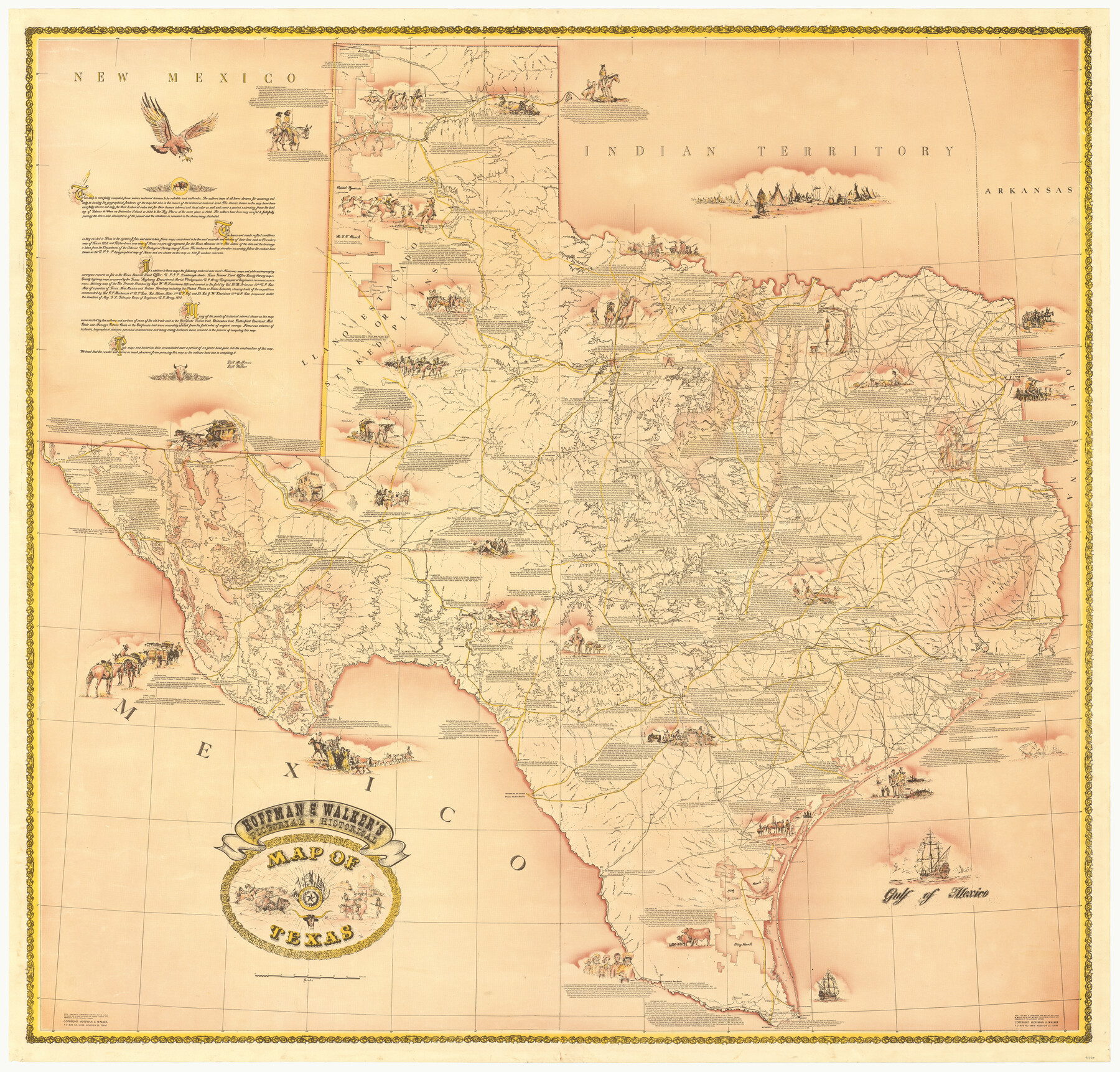
Hoffman & Walker's Pictorial, Historical Map of Texas
-
Map/Doc
93275
-
Collection
General Map Collection
-
Object Dates
1960 - 1969 (Creation Date)
-
People and Organizations
Hoffman & Walker (Publisher)
-
Subjects
Pictorial State of Texas
-
Height x Width
43.4 x 45.3 inches
110.2 x 115.1 cm
-
Comments
Map presented to Col. George I. Taylor, as a gift in 1966 when he was Chief of Staff of the 1st Armored Division while serving at Ft. Hood, Texas.
Donated to the GLO by his children in his honor.
Pictorial and historical. Available for research only. -
URLs
https://medium.com/save-texas-history/illustrated-cartography-pictorial-maps-at-the-glo-hoffman-and-walkers-historical-pictorial-map-55c31eed7cf2#.el8rqclef
Part of: General Map Collection
Chambers County Sketch File 4

Print $40.00
- Digital $50.00
Chambers County Sketch File 4
1859
Size 25.8 x 8.8 inches
Map/Doc 17521
Texas, Matagorda Bay, Vicinity of Carancahua Bay

Print $40.00
- Digital $50.00
Texas, Matagorda Bay, Vicinity of Carancahua Bay
1933
Size 30.3 x 48.2 inches
Map/Doc 69989
Edwards County Sketch File 23

Print $8.00
- Digital $50.00
Edwards County Sketch File 23
1881
Size 14.4 x 9.0 inches
Map/Doc 21747
Bosque County Working Sketch 23

Print $20.00
- Digital $50.00
Bosque County Working Sketch 23
1984
Size 17.4 x 23.6 inches
Map/Doc 67456
Navigation Maps of Gulf Intracoastal Waterway, Port Arthur to Brownsville, Texas

Print $4.00
- Digital $50.00
Navigation Maps of Gulf Intracoastal Waterway, Port Arthur to Brownsville, Texas
1951
Size 16.6 x 21.6 inches
Map/Doc 65422
Refugio County

Print $20.00
- Digital $50.00
Refugio County
1872
Size 17.6 x 22.9 inches
Map/Doc 3987
Medina County Working Sketch 28

Print $20.00
- Digital $50.00
Medina County Working Sketch 28
1988
Size 32.1 x 35.3 inches
Map/Doc 70943
Bowie County Sketch File 8b

Print $6.00
- Digital $50.00
Bowie County Sketch File 8b
1927
Size 6.2 x 9.9 inches
Map/Doc 14875
Waller County Sketch File 12

Print $6.00
- Digital $50.00
Waller County Sketch File 12
1928
Size 7.6 x 8.8 inches
Map/Doc 39616
Hutchinson County Boundary File 4a

Print $40.00
- Digital $50.00
Hutchinson County Boundary File 4a
Size 8.7 x 51.7 inches
Map/Doc 55313
Map of Bosque County

Print $20.00
- Digital $50.00
Map of Bosque County
1869
Size 24.1 x 23.7 inches
Map/Doc 3313
Sterling County Rolled Sketch 16

Print $40.00
- Digital $50.00
Sterling County Rolled Sketch 16
1951
Size 73.6 x 43.0 inches
Map/Doc 9948
You may also like
Fannin County Boundary File 2

Print $27.00
- Digital $50.00
Fannin County Boundary File 2
Size 13.4 x 8.8 inches
Map/Doc 53282
Map of the country adjacent to the left bank of the Rio Grande below Matamoros

Print $20.00
- Digital $50.00
Map of the country adjacent to the left bank of the Rio Grande below Matamoros
1847
Size 18.3 x 28.2 inches
Map/Doc 72871
Flight Mission No. DAG-26K, Frame 63, Matagorda County

Print $20.00
- Digital $50.00
Flight Mission No. DAG-26K, Frame 63, Matagorda County
1953
Size 18.5 x 22.2 inches
Map/Doc 86583
Map of Kimble County, 1860

Print $20.00
- Digital $50.00
Map of Kimble County, 1860
1860
Size 20.7 x 30.5 inches
Map/Doc 3769
Orange County Working Sketch 46

Print $3.00
- Digital $50.00
Orange County Working Sketch 46
1982
Size 10.8 x 9.9 inches
Map/Doc 71378
Van Zandt County Sketch File 29b

Print $4.00
- Digital $50.00
Van Zandt County Sketch File 29b
1859
Size 7.0 x 8.4 inches
Map/Doc 39457
Lamar County Sketch File 1

Print $4.00
- Digital $50.00
Lamar County Sketch File 1
1849
Size 8.0 x 8.2 inches
Map/Doc 29271
Nueces County Sketch File 15

Print $4.00
- Digital $50.00
Nueces County Sketch File 15
1874
Size 7.9 x 9.9 inches
Map/Doc 32545
Map of Ohio, Michigan, Indiana and Kentucky

Print $20.00
- Digital $50.00
Map of Ohio, Michigan, Indiana and Kentucky
1885
Size 12.2 x 9.0 inches
Map/Doc 93520
Pocket Map of the State of Texas reduced from their original map of the State and drawn by Chas. W. Pressler and A. B. Langermann

Print $20.00
Pocket Map of the State of Texas reduced from their original map of the State and drawn by Chas. W. Pressler and A. B. Langermann
1879
Size 24.4 x 26.3 inches
Map/Doc 76208
Travis County Sketch File 29

Print $20.00
- Digital $50.00
Travis County Sketch File 29
1880
Size 12.3 x 21.8 inches
Map/Doc 12459
Shelby County, Texas

Print $40.00
- Digital $50.00
Shelby County, Texas
1897
Size 40.0 x 48.3 inches
Map/Doc 63032