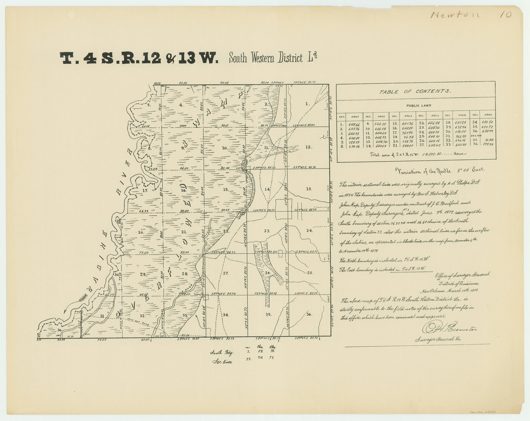
Township 4 South Ranges 12 and 13 West, South Western District, Louisiana
Louisiana Land Surveys Across From Newton County, Texas 10
-
Map/Doc
65884
-
Collection
General Map Collection
-
Object Dates
1879/11/13 (Creation Date)
-
People and Organizations
Surveyor General's Office Louisiana (Publisher)
John Kap (Surveyor/Engineer)
-
Subjects
Texas Boundaries
-
Height x Width
19.6 x 24.7 inches
49.8 x 62.7 cm
-
Comments
Surveyed from November 6, 1879 to November 13, 1879.
Part of: General Map Collection
Harris County Sketch File D

Print $4.00
- Digital $50.00
Harris County Sketch File D
1860
Size 8.1 x 4.9 inches
Map/Doc 25313
Liberty County Sketch File 32

Print $8.00
- Digital $50.00
Liberty County Sketch File 32
1872
Size 10.3 x 8.2 inches
Map/Doc 29961
Working Sketch Patents & Field Notes, Sabine Lake Area

Print $20.00
- Digital $50.00
Working Sketch Patents & Field Notes, Sabine Lake Area
1959
Size 30.2 x 27.0 inches
Map/Doc 2455
Aransas County Sketch File 2a

Print $4.00
- Digital $50.00
Aransas County Sketch File 2a
1868
Size 9.3 x 7.7 inches
Map/Doc 13102
[Sketch for Mineral Application 17237 / Mineral File 11855 - Neches River, Joe A. Sanders]
![65686, [Sketch for Mineral Application 17237 / Mineral File 11855 - Neches River, Joe A. Sanders], General Map Collection](https://historictexasmaps.com/wmedia_w700/maps/65686.tif.jpg)
Print $40.00
- Digital $50.00
[Sketch for Mineral Application 17237 / Mineral File 11855 - Neches River, Joe A. Sanders]
1927
Size 78.2 x 30.7 inches
Map/Doc 65686
Runnels County Rolled Sketch 26

Print $40.00
- Digital $50.00
Runnels County Rolled Sketch 26
1928
Size 55.5 x 25.4 inches
Map/Doc 10312
Flight Mission No. CRC-4R, Frame 99, Chambers County

Print $20.00
- Digital $50.00
Flight Mission No. CRC-4R, Frame 99, Chambers County
1956
Size 18.5 x 22.2 inches
Map/Doc 84896
Rockwall County Working Sketch 2

Print $20.00
- Digital $50.00
Rockwall County Working Sketch 2
1923
Size 20.9 x 16.8 inches
Map/Doc 63594
[Tom Green County]
![82060, [Tom Green County], General Map Collection](https://historictexasmaps.com/wmedia_w700/maps/82060.tif.jpg)
Print $40.00
- Digital $50.00
[Tom Green County]
1888
Size 45.8 x 113.0 inches
Map/Doc 82060
Irion County Working Sketch 10

Print $20.00
- Digital $50.00
Irion County Working Sketch 10
1940
Size 29.6 x 43.5 inches
Map/Doc 66419
Harris County Historic Topographic 1

Print $20.00
- Digital $50.00
Harris County Historic Topographic 1
1916
Size 29.3 x 22.7 inches
Map/Doc 65811
Crosby County Sketch File 22

Print $22.00
- Digital $50.00
Crosby County Sketch File 22
1912
Size 11.3 x 8.6 inches
Map/Doc 20090
You may also like
Leon County Working Sketch 43

Print $40.00
- Digital $50.00
Leon County Working Sketch 43
1980
Size 55.1 x 38.0 inches
Map/Doc 70442
Starr County Sketch File 50

Print $40.00
- Digital $50.00
Starr County Sketch File 50
1963
Size 12.4 x 15.5 inches
Map/Doc 37007

Jack County Sketch File 15

Print $4.00
- Digital $50.00
Jack County Sketch File 15
1880
Size 7.3 x 13.7 inches
Map/Doc 27545

Palestine, Texas

Print $20.00
- Digital $50.00
Palestine, Texas
1942
Size 39.3 x 36.1 inches
Map/Doc 4834
Dickens County Working Sketch 1

Print $20.00
- Digital $50.00
Dickens County Working Sketch 1
Size 15.5 x 15.5 inches
Map/Doc 68648
Maverick County Sketch File 9

Print $8.00
- Digital $50.00
Maverick County Sketch File 9
1878
Size 5.3 x 5.6 inches
Map/Doc 31068
Kenedy County Aerial Photograph Index Sheet 5

Print $20.00
- Digital $50.00
Kenedy County Aerial Photograph Index Sheet 5
1943
Size 23.5 x 19.6 inches
Map/Doc 89046
Menard County Working Sketch 3

Print $20.00
- Digital $50.00
Menard County Working Sketch 3
1913
Size 15.2 x 13.2 inches
Map/Doc 70950
The Military History of Texas Map!

The Military History of Texas Map!
Size 24.2 x 35.2 inches
Map/Doc 94360
Crockett County Rolled Sketch 86

Print $20.00
- Digital $50.00
Crockett County Rolled Sketch 86
1947
Size 31.2 x 27.1 inches
Map/Doc 5626