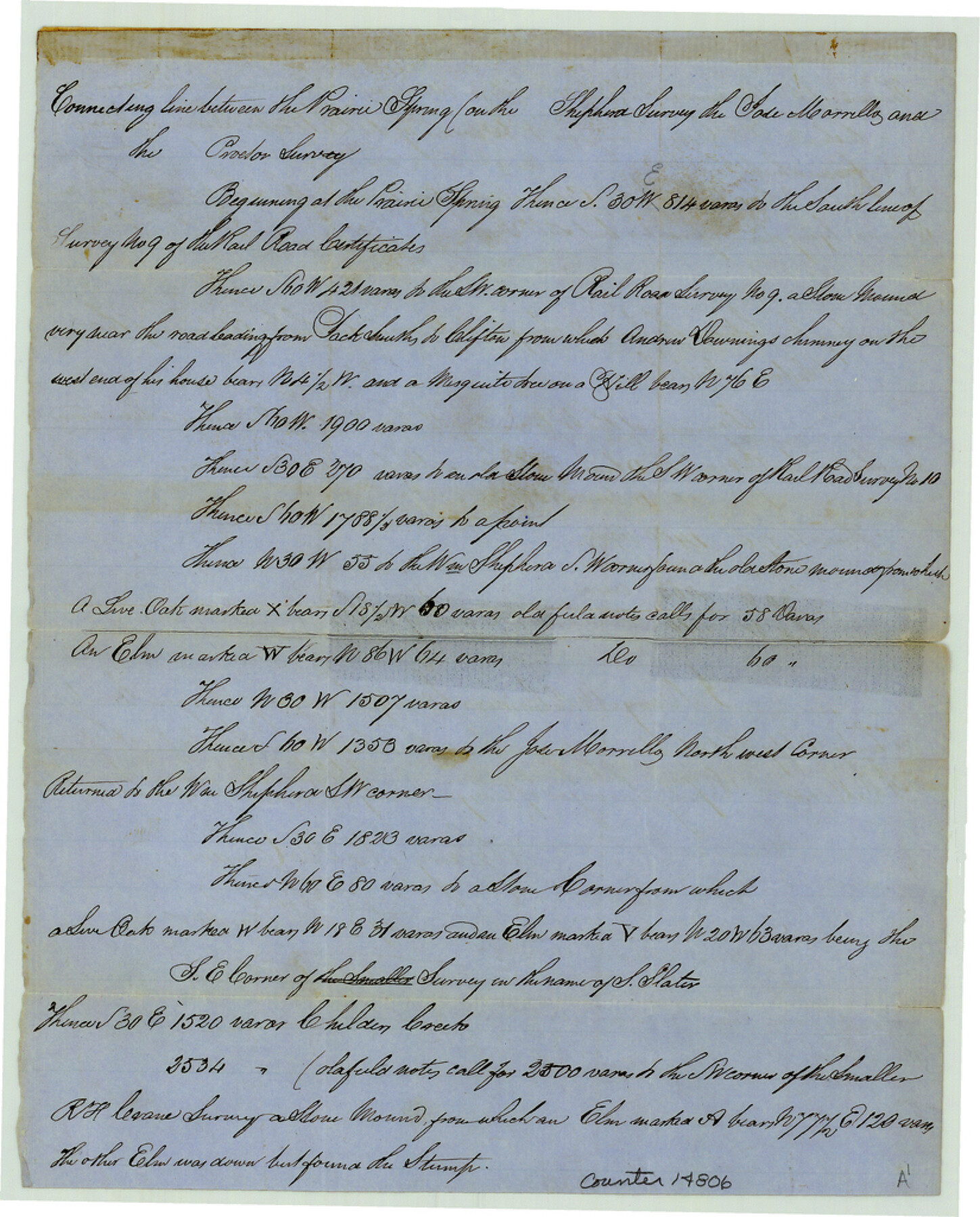
Bosque County Sketch File 23
[Field notes of connecting line between Childers Creek and Brazos River and also connections between David Sample lower survey on Neels Creek and Claiborne Neil survey on the Bosque River]
-
Map/Doc
14806
-
Collection
General Map Collection
-
Object Dates
1863/9/19 (Creation Date)
1863/10/5 (File Date)
-
People and Organizations
Henry M. De Cordova (Surveyor/Engineer)
J. De Cordova (Surveyor/Engineer)
-
Counties
Bosque
-
Subjects
Surveying Sketch File
-
Height x Width
10.2 x 8.2 inches
25.9 x 20.8 cm
-
Medium
paper, manuscript
-
Features
Prairie Spring
Part of: General Map Collection
Brewster County Rolled Sketch 97

Print $20.00
- Digital $50.00
Brewster County Rolled Sketch 97
1952
Size 31.6 x 30.7 inches
Map/Doc 5254
Anderson County Sketch File 6

Print $4.00
- Digital $50.00
Anderson County Sketch File 6
Size 12.5 x 8.2 inches
Map/Doc 12753
Archer County Working Sketch 23

Print $40.00
- Digital $50.00
Archer County Working Sketch 23
1981
Size 31.7 x 48.3 inches
Map/Doc 67164
International boundary between the United States and Mexico in the Rio Grande and Colorado River delineated in accordance with the Treaty of November 23, 1970 - Volume 2

International boundary between the United States and Mexico in the Rio Grande and Colorado River delineated in accordance with the Treaty of November 23, 1970 - Volume 2
1974
Size 25.0 x 35.2 inches
Map/Doc 7641
Floyd County Working Sketch 9

Print $20.00
- Digital $50.00
Floyd County Working Sketch 9
1952
Size 31.5 x 35.9 inches
Map/Doc 69188
T. & N. O. R.R. Jefferson Co. North

Print $20.00
- Digital $50.00
T. & N. O. R.R. Jefferson Co. North
1917
Size 13.5 x 33.2 inches
Map/Doc 64057
Flight Mission No. BRA-8M, Frame 134, Jefferson County

Print $20.00
- Digital $50.00
Flight Mission No. BRA-8M, Frame 134, Jefferson County
1953
Size 18.6 x 22.5 inches
Map/Doc 85630
Falls County Sketch File 18a

Print $8.00
- Digital $50.00
Falls County Sketch File 18a
Size 13.3 x 9.0 inches
Map/Doc 22382
[Galveston, Harrisburg & San Antonio Railroad from Cuero to Stockdale]
![64186, [Galveston, Harrisburg & San Antonio Railroad from Cuero to Stockdale], General Map Collection](https://historictexasmaps.com/wmedia_w700/maps/64186.tif.jpg)
Print $20.00
- Digital $50.00
[Galveston, Harrisburg & San Antonio Railroad from Cuero to Stockdale]
1906
Size 13.4 x 33.1 inches
Map/Doc 64186
Wichita County Sketch File 20

Print $20.00
- Digital $50.00
Wichita County Sketch File 20
Size 12.0 x 22.5 inches
Map/Doc 12683
Briscoe County Sketch File J

Print $40.00
- Digital $50.00
Briscoe County Sketch File J
1919
Size 19.3 x 32.0 inches
Map/Doc 11007
Hardin County Rolled Sketch 19

Print $20.00
- Digital $50.00
Hardin County Rolled Sketch 19
1953
Size 41.2 x 33.8 inches
Map/Doc 10677
You may also like
Medina County Working Sketch 27

Print $20.00
- Digital $50.00
Medina County Working Sketch 27
1985
Size 22.8 x 24.8 inches
Map/Doc 70942
Walker County Working Sketch 18

Print $20.00
- Digital $50.00
Walker County Working Sketch 18
1991
Size 29.4 x 31.5 inches
Map/Doc 72298
General Highway Map, Calhoun County, Texas

Print $20.00
General Highway Map, Calhoun County, Texas
1961
Size 18.3 x 24.4 inches
Map/Doc 79395

Anderson County Boundary File 2

Print $8.00
- Digital $50.00
Anderson County Boundary File 2
Size 14.3 x 8.7 inches
Map/Doc 49730
Kaufman County State Real Property Sketch 2

Print $20.00
- Digital $50.00
Kaufman County State Real Property Sketch 2
2007
Size 24.2 x 35.4 inches
Map/Doc 88672
Webb County Boundary File 2

Print $12.00
- Digital $50.00
Webb County Boundary File 2
Size 11.3 x 8.7 inches
Map/Doc 59710
Navarro County Sketch File 7

Print $4.00
- Digital $50.00
Navarro County Sketch File 7
1854
Size 12.2 x 8.0 inches
Map/Doc 32313
[E. L. & R. R. Block 10]
![91352, [E. L. & R. R. Block 10], Twichell Survey Records](https://historictexasmaps.com/wmedia_w700/maps/91352-1.tif.jpg)
Print $20.00
- Digital $50.00
[E. L. & R. R. Block 10]
Size 25.6 x 15.8 inches
Map/Doc 91352
Robertson County Sketch File 2

Print $16.00
Robertson County Sketch File 2
1858
Size 10.1 x 8.2 inches
Map/Doc 35343
Carta General de la Republica Mexicana

Print $20.00
- Digital $50.00
Carta General de la Republica Mexicana
Size 23.1 x 31.1 inches
Map/Doc 96983
Roberts County Working Sketch 15

Print $20.00
- Digital $50.00
Roberts County Working Sketch 15
1975
Size 40.5 x 38.7 inches
Map/Doc 63541